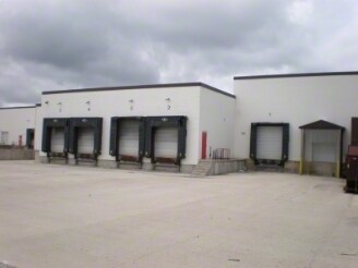
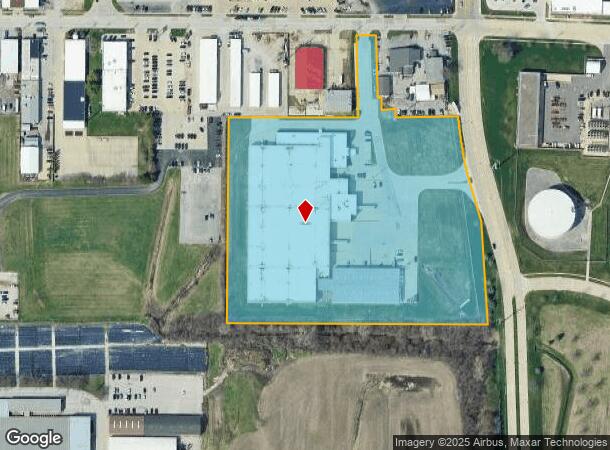
Property Record
2047 Ireland Grove Rd, Bloomington, IL 61704
NEARBY LISTINGS FOR SALE OR LEASE
Property Detail
2047 Ireland Grove Rd
Bloomington, IL
Wilder Sub
21-15-226-028
(EX BEG 71.73, W OF NE COR LOT 2 W220. 08, S33.93, E40.01, S24.22, E186.37, NW58.47, TO POB) LOT 2 WILDER SUB
Industrialgeneral
Mclean
X
Illinois
17113C0504E
2
2022
10.91 AC
2024
Bloomington/Normal
001108
Other Market Areas
308,470 SF
DEMOGRAPHICS near 2047 Ireland Grove Rd
1 Mile
3 Mile
5 Mile
2024 Total Population
3,430
55,542
120,505
2029 Population
3,416
55,929
120,685
Pop Growth 2024-2029
(0.41%)
+ 0.70%
+ 0.15%
Average Age
42
39
37
2024 Total Households
1,856
25,133
49,311
HH Growth 2024-2029
(0.75%)
+ 0.71%
+ 0.16%
Median Household Inc
$60,767
$60,562
$66,845
Avg Household Size
1.70
2.10
2.20
2024 Avg HH Vehicles
1.00
2.00
2.00
Median Home Value
$149,597
$161,791
$179,930
Median Year Built
1974
1971
1979
Nearby Places
Map Layers
Map Styles
 Street
 Aerial
- Restaurants
- Banks
- Shops
- Fitness
- Groceries
PUBLIC TRANSPORTATION
COMMUTER RAIL
DRIVE
WALK
Distance
12 min
4.4 mi
AIRPORT
Central Il Regional/Bloomington-Normal
DRIVE
WALK
Distance
Central Il Regional/Bloomington-Normal
13 min
5.0 mi
Nearby Properties
Address
Land Use
TOTAL SIZE
Lot Size
Zoning
Address
Land Use
TOTAL SIZE
Lot Size
Zoning
131.22 AC
Address
Land Use
TOTAL SIZE
Lot Size
Zoning
1,867,780 SF
48.61 AC
Address
Land Use
TOTAL SIZE
Lot Size
Zoning
682,885 SF
44.48 AC
Address
Land Use
TOTAL SIZE
Lot Size
Zoning
562,852 SF
48.94 AC
Address
Land Use
TOTAL SIZE
Lot Size
Zoning
445,676 SF
20.86 AC
Address
Land Use
TOTAL SIZE
Lot Size
Zoning
1,624,618 SF
54.32 AC
Address
Land Use
TOTAL SIZE
Lot Size
Zoning
333,419 SF
35.07 AC
Address
Land Use
TOTAL SIZE
Lot Size
Zoning
351,208 SF
15.91 AC
Address
Land Use
TOTAL SIZE
Lot Size
Zoning
228,378 SF
7.99 AC
Address
Land Use
TOTAL SIZE
Lot Size
Zoning
362,086 SF
15.40 AC
Address
Land Use
TOTAL SIZE
Lot Size
Zoning
733,822 SF
18.01 AC
Address
Land Use
TOTAL SIZE
Lot Size
Zoning
200,445 SF
8.33 AC
Address
Land Use
TOTAL SIZE
Lot Size
Zoning
275,860 SF
12.17 AC
Address
Land Use
TOTAL SIZE
Lot Size
Zoning
454,529 SF
19.25 AC
Address
Land Use
TOTAL SIZE
Lot Size
Zoning
122,112 SF
7.16 AC
Address
Land Use
TOTAL SIZE
Lot Size
Zoning
276,695 SF
12.68 AC
Address
Land Use
TOTAL SIZE
Lot Size
Zoning
388,851 SF
4.40 AC
Address
Land Use
TOTAL SIZE
Lot Size
Zoning
2,907 SF
96.29 AC
Address
Land Use
TOTAL SIZE
Lot Size
Zoning
295,802 SF
14.99 AC
Address
Land Use
TOTAL SIZE
Lot Size
Zoning
223,726 SF
10.15 AC
Address
Land Use
TOTAL SIZE
Lot Size
Zoning
118,176 SF
2.30 AC
Address
Land Use
TOTAL SIZE
Lot Size
Zoning
97,514 SF
2.70 AC
Address
Land Use
TOTAL SIZE
Lot Size
Zoning
101,129 SF
1.49 AC
Address
Land Use
TOTAL SIZE
Lot Size
Zoning
98,726 SF
3.97 AC
Address
Land Use
TOTAL SIZE
Lot Size
Zoning
336,536 SF
10.98 AC
Address
Land Use
TOTAL SIZE
Lot Size
Zoning
98,540 SF
6.49 AC
Address
Land Use
TOTAL SIZE
Lot Size
Zoning
119,299 SF
8.91 AC
Address
Land Use
TOTAL SIZE
Lot Size
Zoning
1,792 SF
31.52 AC
Address
Land Use
TOTAL SIZE
Lot Size
Zoning
150,550 SF
10.95 AC
Address
Land Use
TOTAL SIZE
Lot Size
Zoning
117,662 SF
5.07 AC
The World's #1 Commercial Real Estate Marketplace
Connect with us
© 2025 CoStar Group
The information above has been obtained from sources believed reliable. While we do not doubt its accuracy we have not verified it and make no guarantee, warranty or representation about it. It is your responsibility to independently confirm its accuracy and completeness. Any projections, opinions, assumptions, or estimates used are for example only and do not represent the current or future performance of the property. The value of this transaction to you depends on tax and other factors which should be evaluated by your tax, financial, and legal advisors. You and your advisors should conduct a careful, independent investigation of the property to determine to your satisfaction the suitability of the property for your needs.