Property Record
20477 E Liberty Rd, Clements, CA 95227
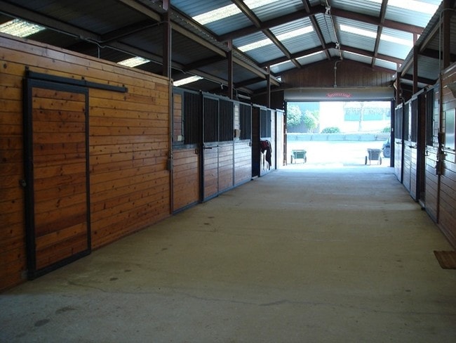


Property Detail
20477 E Liberty Rd
009-190-20
84-FM 03 PT TO 21 & 22 SPLIT PM 12-121
Ranch
SAN JOAQUIN
AG80
California
B and X Area of moderate flood hazard, usually the area between the limits of the 100-year and 500-year floods.
60.73 AC
2025
Lodi
2025
Stockton/Modesto
004703
Stockton-Lodi, CA
4,362 SF
NEARBY LISTINGS FOR SALE OR LEASE
DEMOGRAPHICS near 20477 E Liberty Rd
1 mile
3 mile
5 mile
2025 Total Population
20
309
1,752
2030 Population
20
297
1,705
Pop Growth 2025-2030
0.00%
(3.88%)
(2.68%)
Average Age
45
43
43
2025 Total Households
8
113
628
HH Growth 2025-2030
(12.50%)
(3.54%)
(2.55%)
Median Household Inc
$175,000
$181,818
$155,872
Avg Household Size
2.70
2.70
2.80
2025 Avg HH Vehicles
2.00
2.00
3.00
Median Home Value
$750,000
$750,000
$708,079
Median Year Built
1972
1974
1978
Nearby Places
Map Layers
Map Styles
 Street
 Aerial
Layers
 Traffic
 Biking
Places
Listings with unknown addresses are not visible on the map
- Restaurants
- Banks
- Shops
- Fitness
- Groceries
PUBLIC TRANSPORTATION
AIRPORT
Stockton Metro
Drive
Walk
Distance
Stockton Metro
50 min
32.5 mi
Freight Ports
Port of Stockton
Drive
Walk
Distance
Port of Stockton
49 min
31.0 mi
Nearby Properties
Address
Land Use
TOTAL SIZE
Lot Size
Zoning
Address
Land Use
TOTAL SIZE
Lot Size
Zoning
254.61 AC
AG80
Address
Land Use
TOTAL SIZE
Lot Size
Zoning
1,187 SF
474.38 AC
AG80
Address
Land Use
TOTAL SIZE
Lot Size
Zoning
318.18 AC
AG80
Address
Land Use
TOTAL SIZE
Lot Size
Zoning
5,193 SF
49.16 AC
AG40
Address
Land Use
TOTAL SIZE
Lot Size
Zoning
121.55 AC
Address
Land Use
TOTAL SIZE
Lot Size
Zoning
3,280 SF
4.69 AC
CX
Address
Land Use
TOTAL SIZE
Lot Size
Zoning
80.50 AC
AG40
Address
Land Use
TOTAL SIZE
Lot Size
Zoning
3,658 SF
39.75 AC
AG40
Address
Land Use
TOTAL SIZE
Lot Size
Zoning
2,195 SF
54.37 AC
AG40
Address
Land Use
TOTAL SIZE
Lot Size
Zoning
3,428 SF
25.75 AC
AG80
Address
Land Use
TOTAL SIZE
Lot Size
Zoning
2,866 SF
34.80 AC
AG40
Address
Land Use
TOTAL SIZE
Lot Size
Zoning
117.68 AC
AG40
Address
Land Use
TOTAL SIZE
Lot Size
Zoning
34.86 AC
Address
Land Use
TOTAL SIZE
Lot Size
Zoning
2,469 SF
25.80 AC
AG40
Address
Land Use
TOTAL SIZE
Lot Size
Zoning
3,845 SF
19.97 AC
Address
Land Use
TOTAL SIZE
Lot Size
Zoning
48.27 AC
AG40
Address
Land Use
TOTAL SIZE
Lot Size
Zoning
1,780 SF
39.70 AC
AG40
Address
Land Use
TOTAL SIZE
Lot Size
Zoning
1,163 SF
39.59 AC
AG40
Address
Land Use
TOTAL SIZE
Lot Size
Zoning
131.66 AC
AG80
Address
Land Use
TOTAL SIZE
Lot Size
Zoning
79.98 AC
AG80
Address
Land Use
TOTAL SIZE
Lot Size
Zoning
82.49 AC
AG40
Address
Land Use
TOTAL SIZE
Lot Size
Zoning
5,029 SF
84.93 AC
AG80
Address
Land Use
TOTAL SIZE
Lot Size
Zoning
4,186 SF
39.55 AC
AG40
Address
Land Use
TOTAL SIZE
Lot Size
Zoning
2,220 SF
79.97 AC
AG80
Address
Land Use
TOTAL SIZE
Lot Size
Zoning
84.82 AC
AG40
Address
Land Use
TOTAL SIZE
Lot Size
Zoning
2,459 SF
62.35 AC
AG40
Address
Land Use
TOTAL SIZE
Lot Size
Zoning
79.95 AC
AG80
Address
Land Use
TOTAL SIZE
Lot Size
Zoning
4,021 SF
20.50 AC
AG40
Address
Land Use
TOTAL SIZE
Lot Size
Zoning
3,921 SF
40.01 AC
AG40
The World's #1 Commercial Real Estate Marketplace
Connect with us
© 2026 CoStar Group
The information above has been obtained from sources believed reliable. While we do not doubt its accuracy we have not verified it and make no guarantee, warranty or representation about it. It is your responsibility to independently confirm its accuracy and completeness. Any projections, opinions, assumptions, or estimates used are for example only and do not represent the current or future performance of the property. The value of this transaction to you depends on tax and other factors which should be evaluated by your tax, financial, and legal advisors. You and your advisors should conduct a careful, independent investigation of the property to determine to your satisfaction the suitability of the property for your needs.