Property Record
2048 Mentone Blvd, Mentone, CA 92359
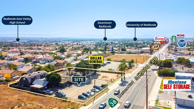
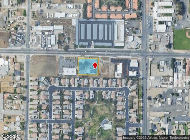
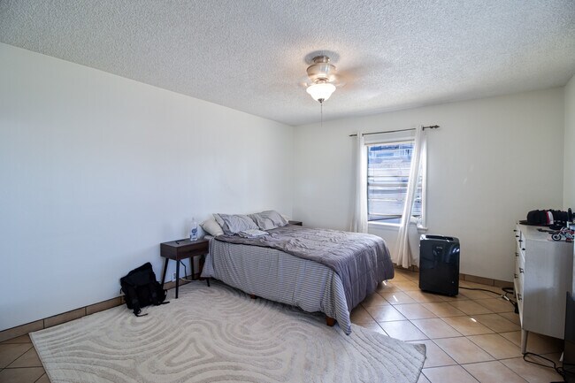
This Property Is For Sale
NEARBY LISTINGS FOR SALE OR LEASE
Property Detail
2048 Mentone Blvd
Riverside-San Bernardino-Ontario, CA
Tract No 3789
0298-183-25
San Bernardino
Duplex
California
X
0.81 AC
06071C8730J
Redlands/Loma Linda
3,982 SF
Inland Empire (California)
DEMOGRAPHICS near 2048 Mentone Blvd
1 Mile
3 Mile
5 Mile
2024 Total Population
7,881
41,450
120,010
2029 Population
7,967
42,161
122,135
Pop Growth 2024-2029
+ 1.09%
+ 1.72%
+ 1.77%
Average Age
38
38
39
2024 Total Households
2,762
14,019
41,837
HH Growth 2024-2029
+ 1.16%
+ 1.79%
+ 1.82%
Median Household Inc
$78,403
$96,259
$96,041
Avg Household Size
2.80
2.80
2.80
2024 Avg HH Vehicles
2.00
2.00
2.00
Median Home Value
$424,697
$491,785
$500,796
Median Year Built
1984
1979
1980
Nearby Places
Map Layers
Map Styles
 Street
 Aerial
- Restaurants
- Banks
- Shops
- Fitness
- Groceries
PUBLIC TRANSPORTATION
COMMUTER RAIL
Redlands - University Metrolink Station (Metrolink San Bernardino Line - Metrolink Trains)
DRIVE
WALK
Distance
Redlands - University Metrolink Station (Metrolink San Bernardino Line - Metrolink Trains)
8 min
3.8 mi
Redlands - Downtown Metrolink Station (Metrolink San Bernardino Line - Metrolink Trains)
DRIVE
WALK
Distance
Redlands - Downtown Metrolink Station (Metrolink San Bernardino Line - Metrolink Trains)
9 min
4.3 mi
AIRPORT
Ontario International
DRIVE
WALK
Distance
Ontario International
38 min
28.8 mi
Freight Ports
Port of Long Beach
DRIVE
WALK
Distance
Port of Long Beach
96 min
74.2 mi
Nearby Properties
Address
Land Use
TOTAL SIZE
Lot Size
Zoning
Address
Land Use
TOTAL SIZE
Lot Size
Zoning
56.83 AC
Address
Land Use
TOTAL SIZE
Lot Size
Zoning
166,788 SF
11.74 AC
Address
Land Use
TOTAL SIZE
Lot Size
Zoning
82,356 SF
5.10 AC
RM
Address
Land Use
TOTAL SIZE
Lot Size
Zoning
127,850 SF
6.89 AC
IC
Address
Land Use
TOTAL SIZE
Lot Size
Zoning
123,230 SF
6.33 AC
CGSCP
Address
Land Use
TOTAL SIZE
Lot Size
Zoning
37.87 AC
RS
Address
Land Use
TOTAL SIZE
Lot Size
Zoning
31.34 AC
Address
Land Use
TOTAL SIZE
Lot Size
Zoning
17,278 SF
5.08 AC
Address
Land Use
TOTAL SIZE
Lot Size
Zoning
2,527 SF
35.13 AC
IC
Address
Land Use
TOTAL SIZE
Lot Size
Zoning
39,424 SF
3.07 AC
Z2
Address
Land Use
TOTAL SIZE
Lot Size
Zoning
47,280 SF
3.45 AC
Address
Land Use
TOTAL SIZE
Lot Size
Zoning
36,892 SF
2.30 AC
RM
Address
Land Use
TOTAL SIZE
Lot Size
Zoning
41,000 SF
3.41 AC
Address
Land Use
TOTAL SIZE
Lot Size
Zoning
62,115 SF
13.20 AC
Address
Land Use
TOTAL SIZE
Lot Size
Zoning
15,162 SF
2.73 AC
Address
Land Use
TOTAL SIZE
Lot Size
Zoning
63,917 SF
6.61 AC
Address
Land Use
TOTAL SIZE
Lot Size
Zoning
43,250 SF
6.70 AC
Address
Land Use
TOTAL SIZE
Lot Size
Zoning
45,565 SF
4.48 AC
Address
Land Use
TOTAL SIZE
Lot Size
Zoning
16,455 SF
1.56 AC
Address
Land Use
TOTAL SIZE
Lot Size
Zoning
34.60 AC
Address
Land Use
TOTAL SIZE
Lot Size
Zoning
11,001 SF
1.08 AC
Address
Land Use
TOTAL SIZE
Lot Size
Zoning
44,294 SF
2.27 AC
IC
Address
Land Use
TOTAL SIZE
Lot Size
Zoning
28,800 SF
2 AC
R2
Address
Land Use
TOTAL SIZE
Lot Size
Zoning
27.20 AC
Address
Land Use
TOTAL SIZE
Lot Size
Zoning
51,682 SF
19.58 AC
Address
Land Use
TOTAL SIZE
Lot Size
Zoning
14,559 SF
4.98 AC
Address
Land Use
TOTAL SIZE
Lot Size
Zoning
6.53 AC
Address
Land Use
TOTAL SIZE
Lot Size
Zoning
7,098 SF
1.28 AC
Address
Land Use
TOTAL SIZE
Lot Size
Zoning
167,130 SF
7.80 AC
Address
Land Use
TOTAL SIZE
Lot Size
Zoning
75,696 SF
3.53 AC
CGSCP
The World's #1 Commercial Real Estate Marketplace
Connect with us
© 2026 CoStar Group
The information above has been obtained from sources believed reliable. While we do not doubt its accuracy we have not verified it and make no guarantee, warranty or representation about it. It is your responsibility to independently confirm its accuracy and completeness. Any projections, opinions, assumptions, or estimates used are for example only and do not represent the current or future performance of the property. The value of this transaction to you depends on tax and other factors which should be evaluated by your tax, financial, and legal advisors. You and your advisors should conduct a careful, independent investigation of the property to determine to your satisfaction the suitability of the property for your needs.