Property Record
2048 N Lapeer Rd, Lapeer, MI 48446
NEARBY LISTINGS FOR SALE OR LEASE
-
-
-
No Photo
-
View all Lapeer listings for sale on LoopNet.com
Property Detail
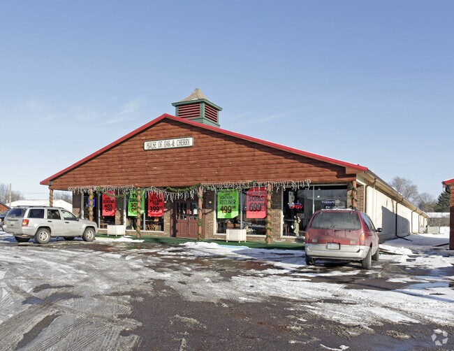
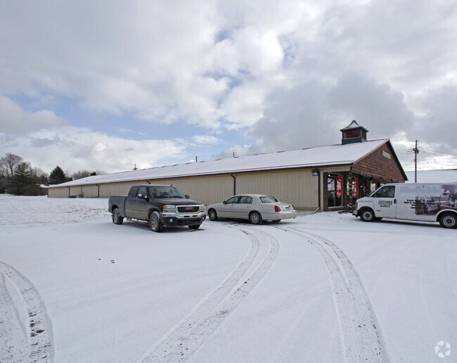
2048 N Lapeer Rd
014-021-028-00
SEC 21 T8N R10E COM S 89 DEG 34' W 881 FT AND N 535 FT FROM SE COR OF SW 1/4 OF SW 1/4, TH S 89 DEG 34' W 368 FT TO E LINE OF
Storebuilding
Lapeer
X
Michigan
26087C0258E
2 AC
2024
St Clair & Lapeer Counties
2025
Detroit
333500
Detroit-Warren-Dearborn, MI
14,984 SF
DEMOGRAPHICS near 2048 N Lapeer Rd
1 Mile
3 Mile
5 Mile
2024 Total Population
1,228
12,985
23,159
2029 Population
1,235
13,050
23,251
Pop Growth 2024-2029
+ 0.57%
+ 0.50%
+ 0.40%
Average Age
44
42
43
2024 Total Households
486
5,486
9,587
HH Growth 2024-2029
+ 0.62%
+ 0.49%
+ 0.41%
Median Household Inc
$55,425
$51,441
$61,279
Avg Household Size
2.40
2.30
2.30
2024 Avg HH Vehicles
2.00
2.00
2.00
Median Home Value
$158,219
$155,671
$169,678
Median Year Built
1977
1975
1977
Nearby Places
Map Layers
Map Styles
 Street
 Aerial
- Restaurants
- Banks
- Shops
- Fitness
- Groceries
PUBLIC TRANSPORTATION
COMMUTER RAIL
Lapeer Amtrak Station (Blue Water - Amtrak)
DRIVE
WALK
Distance
Lapeer Amtrak Station (Blue Water - Amtrak)
7 min
3.5 mi
AIRPORT
Bishop International
DRIVE
WALK
Distance
Bishop International
46 min
31.6 mi
Freight Ports
Port of Toledo
DRIVE
WALK
Distance
Port of Toledo
154 min
120.0 mi
Nearby Properties
Address
Land Use
TOTAL SIZE
Lot Size
Zoning
Address
Land Use
TOTAL SIZE
Lot Size
Zoning
216,630 SF
33.87 AC
B3 REG
Address
Land Use
TOTAL SIZE
Lot Size
Zoning
184,894 SF
21.97 AC
RM-1 M
Address
Land Use
TOTAL SIZE
Lot Size
Zoning
108.23 AC
MHP
Address
Land Use
TOTAL SIZE
Lot Size
Zoning
672 SF
40 AC
MHP
Address
Land Use
TOTAL SIZE
Lot Size
Zoning
240,748 SF
22.20 AC
I1 INDU
Address
Land Use
TOTAL SIZE
Lot Size
Zoning
142,610 SF
35.53 AC
M-2
Address
Land Use
TOTAL SIZE
Lot Size
Zoning
80,728 SF
20 AC
RM-1 M
Address
Land Use
TOTAL SIZE
Lot Size
Zoning
55,270 SF
4.80 AC
R2 1 FM
Address
Land Use
TOTAL SIZE
Lot Size
Zoning
94,442 SF
9 AC
B2 GEN
Address
Land Use
TOTAL SIZE
Lot Size
Zoning
528 SF
21 AC
MHP
Address
Land Use
TOTAL SIZE
Lot Size
Zoning
17,750 SF
2.34 AC
OS-1
Address
Land Use
TOTAL SIZE
Lot Size
Zoning
5.59 AC
RM-1 M
Address
Land Use
TOTAL SIZE
Lot Size
Zoning
590 AC
R-1
Address
Land Use
TOTAL SIZE
Lot Size
Zoning
95,544 SF
8.39 AC
RM-1 M
Address
Land Use
TOTAL SIZE
Lot Size
Zoning
15,565 SF
0.70 AC
I1 INDU
Address
Land Use
TOTAL SIZE
Lot Size
Zoning
3.84 AC
RM-1 M
Address
Land Use
TOTAL SIZE
Lot Size
Zoning
31,914 SF
4.85 AC
B2 GEN
Address
Land Use
TOTAL SIZE
Lot Size
Zoning
48,226 SF
2.71 AC
RM-1 M
Address
Land Use
TOTAL SIZE
Lot Size
Zoning
29,394 SF
2.82 AC
B2 GEN
Address
Land Use
TOTAL SIZE
Lot Size
Zoning
0.36 AC
CBD1 CEN B
Address
Land Use
TOTAL SIZE
Lot Size
Zoning
61,860 SF
7.02 AC
RM
Address
Land Use
TOTAL SIZE
Lot Size
Zoning
14,894 SF
4.59 AC
C-2
Address
Land Use
TOTAL SIZE
Lot Size
Zoning
384.30 AC
R-1
Address
Land Use
TOTAL SIZE
Lot Size
Zoning
13,012 SF
2.24 AC
OS-1
Address
Land Use
TOTAL SIZE
Lot Size
Zoning
128,094 SF
4.42 AC
I1 INDU
Address
Land Use
TOTAL SIZE
Lot Size
Zoning
50,580 SF
9.40 AC
C-2
Address
Land Use
TOTAL SIZE
Lot Size
Zoning
47,652 SF
3.27 AC
RM-1 M
Address
Land Use
TOTAL SIZE
Lot Size
Zoning
33,790 SF
1.52 AC
B2 GEN
Address
Land Use
TOTAL SIZE
Lot Size
Zoning
339,680 SF
48.66 AC
M-2
Address
Land Use
TOTAL SIZE
Lot Size
Zoning
R1 1 FM
The World's #1 Commercial Real Estate Marketplace
Connect with us
© 2025 CoStar Group
The information above has been obtained from sources believed reliable. While we do not doubt its accuracy we have not verified it and make no guarantee, warranty or representation about it. It is your responsibility to independently confirm its accuracy and completeness. Any projections, opinions, assumptions, or estimates used are for example only and do not represent the current or future performance of the property. The value of this transaction to you depends on tax and other factors which should be evaluated by your tax, financial, and legal advisors. You and your advisors should conduct a careful, independent investigation of the property to determine to your satisfaction the suitability of the property for your needs.