Property Record
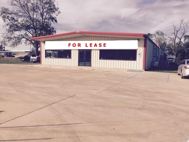
2048 Old Natchitoches Rd, West Monroe, LA 71292

NEARBY LISTINGS FOR SALE OR LEASE
Property Detail
2048 Old Natchitoches Rd
50728
1.799 ACS M/L IN SEC 34, T18N R3E FROM INTERSECTION OF E R/W OF RT LA 617 (THOMAS RD) WITH N R/W OF OLD NATCHITOCHES RD, N50W 46.02 FT, RUN ALONG ARC OF CURVE TO LEFT, RADIUS 11,509.16 FT (LONG CHORD N 89.01), AN ARC DIST OF 89.01 FT, N89E 200 FT, N
Industrialgeneral
Ouachita
X
Louisiana
22073C0145F
1.79 AC
2025
Louisiana North Area
2024
Other Market Areas
005800
Monroe, LA
9,982 SF
DEMOGRAPHICS near 2048 Old Natchitoches Rd
1 mile
3 mile
5 mile
2024 Total Population
3,150
36,243
81,639
2029 Population
3,104
35,686
80,179
Pop Growth 2024-2029
(1.46%)
(1.54%)
(1.79%)
Average Age
41
40
39
2024 Total Households
1,365
15,502
33,147
HH Growth 2024-2029
(1.61%)
(1.64%)
(1.84%)
Median Household Inc
$48,028
$46,106
$44,569
Avg Household Size
2.20
2.20
2.40
2024 Avg HH Vehicles
1.00
2.00
2.00
Median Home Value
$89,361
$147,634
$167,819
Median Year Built
1980
1978
1977
Nearby Places
Map Layers
Map Styles
 Street
 Aerial
Transit
 Traffic
 Biking
Places
Listings with unknown addresses are not visible on the map
- Restaurants
- Banks
- Shops
- Fitness
- Groceries
PUBLIC TRANSPORTATION
AIRPORT
Monroe Regional
Drive
Walk
Distance
Monroe Regional
13 min
8.7 mi
Freight Ports
Port of Shreveport
Drive
Walk
Distance
Port of Shreveport
127 min
108.6 mi
Nearby Properties
Address
Land Use
TOTAL SIZE
Lot Size
Zoning
Address
Land Use
TOTAL SIZE
Lot Size
Zoning
2.23 AC
Address
Land Use
TOTAL SIZE
Lot Size
Zoning
11.51 AC
Address
Land Use
TOTAL SIZE
Lot Size
Zoning
Address
Land Use
TOTAL SIZE
Lot Size
Zoning
Address
Land Use
TOTAL SIZE
Lot Size
Zoning
2.49 AC
Address
Land Use
TOTAL SIZE
Lot Size
Zoning
0.14 AC
Address
Land Use
TOTAL SIZE
Lot Size
Zoning
15.74 AC
Address
Land Use
TOTAL SIZE
Lot Size
Zoning
23.29 AC
Address
Land Use
TOTAL SIZE
Lot Size
Zoning
105.67 AC
Address
Land Use
TOTAL SIZE
Lot Size
Zoning
Address
Land Use
TOTAL SIZE
Lot Size
Zoning
3.66 AC
Address
Land Use
TOTAL SIZE
Lot Size
Zoning
Address
Land Use
TOTAL SIZE
Lot Size
Zoning
18.85 AC
Address
Land Use
TOTAL SIZE
Lot Size
Zoning
14.09 AC
Address
Land Use
TOTAL SIZE
Lot Size
Zoning
10.67 AC
Address
Land Use
TOTAL SIZE
Lot Size
Zoning
6.42 AC
Address
Land Use
TOTAL SIZE
Lot Size
Zoning
1.16 AC
Address
Land Use
TOTAL SIZE
Lot Size
Zoning
2.48 AC
Address
Land Use
TOTAL SIZE
Lot Size
Zoning
0.52 AC
Address
Land Use
TOTAL SIZE
Lot Size
Zoning
Address
Land Use
TOTAL SIZE
Lot Size
Zoning
Address
Land Use
TOTAL SIZE
Lot Size
Zoning
2.09 AC
Address
Land Use
TOTAL SIZE
Lot Size
Zoning
Address
Land Use
TOTAL SIZE
Lot Size
Zoning
Address
Land Use
TOTAL SIZE
Lot Size
Zoning
0.28 AC
Address
Land Use
TOTAL SIZE
Lot Size
Zoning
Address
Land Use
TOTAL SIZE
Lot Size
Zoning
Address
Land Use
TOTAL SIZE
Lot Size
Zoning
5.19 AC
Address
Land Use
TOTAL SIZE
Lot Size
Zoning
4.43 AC
Address
Land Use
TOTAL SIZE
Lot Size
Zoning
5.86 AC
The World's #1 Commercial Real Estate Marketplace
Connect with us
© 2026 CoStar Group
The information above has been obtained from sources believed reliable. While we do not doubt its accuracy we have not verified it and make no guarantee, warranty or representation about it. It is your responsibility to independently confirm its accuracy and completeness. Any projections, opinions, assumptions, or estimates used are for example only and do not represent the current or future performance of the property. The value of this transaction to you depends on tax and other factors which should be evaluated by your tax, financial, and legal advisors. You and your advisors should conduct a careful, independent investigation of the property to determine to your satisfaction the suitability of the property for your needs.