Property Record
2049 Adams Rd, Mccomb, MS 39648
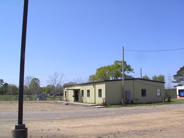


Property Detail
2049 Adams Rd
811960-B
TCT LY IN W1/2 SE1/4 SE1/4 & 20' EASEMENT ZN:X-28113C0125C
Officebuilding
Pike
B and X Area of moderate flood hazard, usually the area between the limits of the 100-year and 500-year floods.
Mississippi
2025
13.72 AC
2025
Hattiesburg/South Area
950103
Other Market Areas
3,165 SF
McComb, MS
NEARBY LISTINGS FOR SALE OR LEASE
-
-
View all Mccomb listings for sale on LoopNet.com
DEMOGRAPHICS near 2049 Adams Rd
1 mile
3 mile
5 mile
2025 Total Population
521
7,707
20,948
2030 Population
500
7,482
20,391
Pop Growth 2025-2030
(4.03%)
(2.92%)
(2.66%)
Average Age
39
38
39
2025 Total Households
199
3,001
8,463
HH Growth 2025-2030
(4.02%)
(2.90%)
(2.63%)
Median Household Inc
$33,690
$40,199
$40,919
Avg Household Size
2.60
2.50
2.40
2025 Avg HH Vehicles
2.00
2.00
2.00
Median Home Value
$142,857
$120,451
$118,876
Median Year Built
1979
1978
1978
Nearby Places
Map Layers
Map Styles
 Street
 Aerial
Layers
 Traffic
 Biking
Places
Listings with unknown addresses are not visible on the map
- Restaurants
- Banks
- Shops
- Fitness
- Groceries
PUBLIC TRANSPORTATION
COMMUTER RAIL
Mccomb (City of New Orleans - Amtrak)
Drive
Walk
Distance
Mccomb (City of New Orleans - Amtrak)
9 min
4.4 mi
Freight Ports
Port of Greater Baton Rouge
Drive
Walk
Distance
Port of Greater Baton Rouge
118 min
98.2 mi
SALE & LEASE HISTORY
LISTING DATE
SALE/LEASE

Sep 25, 2016
For Lease
Sep 24, 2019
For Sale
Sep 23, 2016
For Sale
Aug 31, 2017
For Sale
Nearby Properties
Address
Land Use
TOTAL SIZE
Lot Size
Zoning
Address
Land Use
TOTAL SIZE
Lot Size
Zoning
70,328 SF
9.12 AC
Address
Land Use
TOTAL SIZE
Lot Size
Zoning
21,390 SF
12.37 AC
Address
Land Use
TOTAL SIZE
Lot Size
Zoning
32,401 SF
6.42 AC
C2
Address
Land Use
TOTAL SIZE
Lot Size
Zoning
1,665 SF
222.81 AC
Address
Land Use
TOTAL SIZE
Lot Size
Zoning
60,090 SF
19.40 AC
Address
Land Use
TOTAL SIZE
Lot Size
Zoning
1,447 SF
6.17 AC
RPL
Address
Land Use
TOTAL SIZE
Lot Size
Zoning
21,390 SF
6.04 AC
Address
Land Use
TOTAL SIZE
Lot Size
Zoning
8,866 SF
70.05 AC
I2
Address
Land Use
TOTAL SIZE
Lot Size
Zoning
4,721 SF
2.71 AC
Address
Land Use
TOTAL SIZE
Lot Size
Zoning
110,395 SF
2.48 AC
SCD
Address
Land Use
TOTAL SIZE
Lot Size
Zoning
8,231 SF
2.30 AC
Address
Land Use
TOTAL SIZE
Lot Size
Zoning
125,285 SF
13.51 AC
I2
Address
Land Use
TOTAL SIZE
Lot Size
Zoning
17,512 SF
1.33 AC
SCD
Address
Land Use
TOTAL SIZE
Lot Size
Zoning
10,950 SF
3.03 AC
Address
Land Use
TOTAL SIZE
Lot Size
Zoning
7,680 SF
0.99 AC
Address
Land Use
TOTAL SIZE
Lot Size
Zoning
7,774 SF
2.70 AC
IPL
Address
Land Use
TOTAL SIZE
Lot Size
Zoning
10,600 SF
136.16 AC
Address
Land Use
TOTAL SIZE
Lot Size
Zoning
28,287 SF
Address
Land Use
TOTAL SIZE
Lot Size
Zoning
10,040 SF
1.43 AC
Address
Land Use
TOTAL SIZE
Lot Size
Zoning
68,193 SF
16.50 AC
Address
Land Use
TOTAL SIZE
Lot Size
Zoning
2,036 SF
14.29 AC
RPL
Address
Land Use
TOTAL SIZE
Lot Size
Zoning
45,298 SF
6.71 AC
RPL
Address
Land Use
TOTAL SIZE
Lot Size
Zoning
8,639 SF
1.11 AC
C2
Address
Land Use
TOTAL SIZE
Lot Size
Zoning
41,218 SF
4.32 AC
C2
Address
Land Use
TOTAL SIZE
Lot Size
Zoning
45,174 SF
3 AC
R60
Address
Land Use
TOTAL SIZE
Lot Size
Zoning
8,388 SF
0.63 AC
RPL
Address
Land Use
TOTAL SIZE
Lot Size
Zoning
7,519 SF
0.52 AC
SCD
Address
Land Use
TOTAL SIZE
Lot Size
Zoning
8,180 SF
0.65 AC
SCD
Address
Land Use
TOTAL SIZE
Lot Size
Zoning
6,047 SF
0.55 AC
Address
Land Use
TOTAL SIZE
Lot Size
Zoning
4,005 SF
1.18 AC
The World's #1 Commercial Real Estate Marketplace
Connect with us
© 2026 CoStar Group
The information above has been obtained from sources believed reliable. While we do not doubt its accuracy we have not verified it and make no guarantee, warranty or representation about it. It is your responsibility to independently confirm its accuracy and completeness. Any projections, opinions, assumptions, or estimates used are for example only and do not represent the current or future performance of the property. The value of this transaction to you depends on tax and other factors which should be evaluated by your tax, financial, and legal advisors. You and your advisors should conduct a careful, independent investigation of the property to determine to your satisfaction the suitability of the property for your needs.