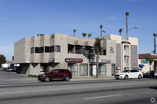
Property Record
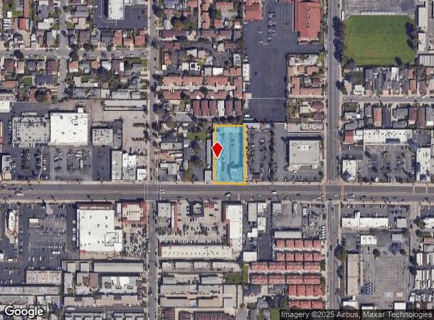
2041 Pacific Coast Hwy, Lomita, CA 90717

NEARBY LISTINGS FOR SALE OR LEASE
Property Detail
2041 Pacific Coast Hwy
Los Angeles-Long Beach-Glendale, CA
848
7375-023-056
TR=848 EX OF ST LOT 207
Officebuilding
Los Angeles
X
California
06037C1940F
207
2024
0.83 AC
2025
Torrance
670002
Los Angeles
19,993 SF
DEMOGRAPHICS near 2041 Pacific Coast Hwy
1 Mile
3 Mile
5 Mile
2024 Total Population
31,154
189,112
436,200
2029 Population
30,278
183,103
423,129
Pop Growth 2024-2029
(2.81%)
(3.18%)
(3.00%)
Average Age
41
41
42
2024 Total Households
11,744
65,320
152,444
HH Growth 2024-2029
(3.02%)
(3.39%)
(3.19%)
Median Household Inc
$80,583
$91,946
$93,255
Avg Household Size
2.60
2.80
2.70
2024 Avg HH Vehicles
2.00
2.00
2.00
Median Home Value
$728,021
$783,056
$840,068
Median Year Built
1967
1967
1965
Nearby Places
- Restaurants
- Banks
- Shops
- Fitness
- Groceries
PUBLIC TRANSPORTATION
AIRPORT
Long Beach (Daugherty Field)
DRIVE
WALK
Distance
Long Beach (Daugherty Field)
20 min
11.0 mi
Los Angeles International
DRIVE
WALK
Distance
Los Angeles International
25 min
16.0 mi
John Wayne/Orange County
DRIVE
WALK
Distance
John Wayne/Orange County
42 min
31.2 mi
Nearby Properties
Address
Land Use
TOTAL SIZE
Lot Size
Zoning
Address
Land Use
TOTAL SIZE
Lot Size
Zoning
767,582 SF
13.62 AC
TOHHM
Address
Land Use
TOTAL SIZE
Lot Size
Zoning
671,091 SF
18 AC
LAC1
Address
Land Use
TOTAL SIZE
Lot Size
Zoning
1,261,764 SF
26.51 AC
TOMI-LT
Address
Land Use
TOTAL SIZE
Lot Size
Zoning
5,086 SF
255.48 AC
LAM3
Address
Land Use
TOTAL SIZE
Lot Size
Zoning
246,981 SF
11.95 AC
LARD2
Address
Land Use
TOTAL SIZE
Lot Size
Zoning
131,101 SF
14.03 AC
TOPC-GEN
Address
Land Use
TOTAL SIZE
Lot Size
Zoning
84,365 SF
7.62 AC
LARAS3
Address
Land Use
TOTAL SIZE
Lot Size
Zoning
429,141 SF
3.29 AC
LCM1*
Address
Land Use
TOTAL SIZE
Lot Size
Zoning
426,285 SF
LAC2
Address
Land Use
TOTAL SIZE
Lot Size
Zoning
170,000 SF
7.61 AC
LARD1.5
Address
Land Use
TOTAL SIZE
Lot Size
Zoning
100,149 SF
1.99 AC
TORR-MD
Address
Land Use
TOTAL SIZE
Lot Size
Zoning
759,851 SF
33.72 AC
LAM3
Address
Land Use
TOTAL SIZE
Lot Size
Zoning
191,424 SF
7.71 AC
LARD1.5
Address
Land Use
TOTAL SIZE
Lot Size
Zoning
174,910 SF
131.43 AC
LAM3
Address
Land Use
TOTAL SIZE
Lot Size
Zoning
269,859 SF
11.14 AC
RPRS-4*
Address
Land Use
TOTAL SIZE
Lot Size
Zoning
81,328 SF
3.13 AC
TOCC-GEN
Address
Land Use
TOTAL SIZE
Lot Size
Zoning
67,581 SF
1.49 AC
OLD PCL003
Address
Land Use
TOTAL SIZE
Lot Size
Zoning
365,701 SF
2.45 AC
TOMI-BP
Address
Land Use
TOTAL SIZE
Lot Size
Zoning
10.30 AC
TOM2*
Address
Land Use
TOTAL SIZE
Lot Size
Zoning
128,631 SF
15.23 AC
TOPC-GEN
Address
Land Use
TOTAL SIZE
Lot Size
Zoning
115,399 SF
12.10 AC
TOPC-GEN
Address
Land Use
TOTAL SIZE
Lot Size
Zoning
170,577 SF
16 AC
TOM2*
Address
Land Use
TOTAL SIZE
Lot Size
Zoning
76,807 SF
1.76 AC
TOHHM
Address
Land Use
TOTAL SIZE
Lot Size
Zoning
512,700 SF
20.65 AC
LAM3
Address
Land Use
TOTAL SIZE
Lot Size
Zoning
65,832 SF
4.57 AC
TOMI-LT
Address
Land Use
TOTAL SIZE
Lot Size
Zoning
326,897 SF
3.33 AC
TOHHM
Address
Land Use
TOTAL SIZE
Lot Size
Zoning
74,301 SF
3.54 AC
TOHHM
Address
Land Use
TOTAL SIZE
Lot Size
Zoning
131,529 SF
9.83 AC
LAM1
Address
Land Use
TOTAL SIZE
Lot Size
Zoning
169,947 SF
1.81 AC
LAC2
Address
Land Use
TOTAL SIZE
Lot Size
Zoning
135,880 SF
12.40 AC
TOPC-GEN
The World's #1 Commercial Real Estate Marketplace
Connect with us
© 2025 CoStar Group
The information above has been obtained from sources believed reliable. While we do not doubt its accuracy we have not verified it and make no guarantee, warranty or representation about it. It is your responsibility to independently confirm its accuracy and completeness. Any projections, opinions, assumptions, or estimates used are for example only and do not represent the current or future performance of the property. The value of this transaction to you depends on tax and other factors which should be evaluated by your tax, financial, and legal advisors. You and your advisors should conduct a careful, independent investigation of the property to determine to your satisfaction the suitability of the property for your needs.