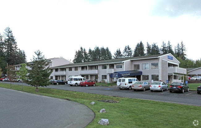
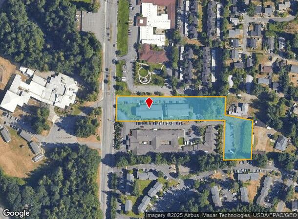
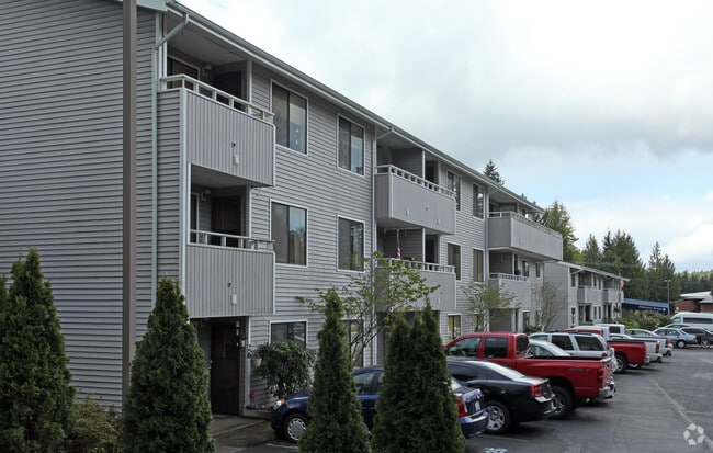
Property Record
2049 Pottery Ave, Port Orchard, WA 98366
NEARBY LISTINGS FOR SALE OR LEASE
-
-
View all Port Orchard listings for sale on LoopNet.com
Property Detail
2049 Pottery Ave
Bremerton-Silverdale, WA
Port Orchard
022301-2-073-2004
PARCEL A: THAT PORTION OF THE SOUTHWEST QUARTER OF THE NORTHWEST QUARTER, SECTION 2, TOWNSHIP 23 NORTH, RANGE 1 EAST, WILLAMETTE MERIDIAN, IN KITSAP COUNTY, WASHINGTON, DESCRIBED AS FOLLOWS: BEGINNING AT THE NORTHWEST CORNER OF SAID SOUTHWEST QUARTER
Hospitalprivate
Kitsap
X
Washington
53035C0369E
73
2025
2.54 AC
2026
Port Orchard
092200
Bremerton/Silverdale
43,318 SF
DEMOGRAPHICS near 2049 Pottery Ave
1 Mile
3 Mile
5 Mile
2024 Total Population
7,090
42,417
93,338
2029 Population
7,264
43,143
94,630
Pop Growth 2024-2029
+ 2.45%
+ 1.71%
+ 1.38%
Average Age
38
39
40
2024 Total Households
2,646
15,982
35,203
HH Growth 2024-2029
+ 2.46%
+ 1.70%
+ 1.55%
Median Household Inc
$52,061
$77,107
$73,100
Avg Household Size
2.50
2.50
2.40
2024 Avg HH Vehicles
2.00
2.00
2.00
Median Home Value
$375,629
$399,403
$410,570
Median Year Built
1986
1987
1981
Nearby Places
Map Layers
Map Styles
 Street
 Aerial
- Restaurants
- Banks
- Shops
- Fitness
- Groceries
PUBLIC TRANSPORTATION
AIRPORT
Seattle-Tacoma International
DRIVE
WALK
Distance
Seattle-Tacoma International
66 min
46.9 mi
Freight Ports
Port of Seattle
DRIVE
WALK
Distance
Port of Seattle
76 min
57.2 mi
Nearby Properties
Address
Land Use
TOTAL SIZE
Lot Size
Zoning
Address
Land Use
TOTAL SIZE
Lot Size
Zoning
552 SF
17.39 AC
CITY
Address
Land Use
TOTAL SIZE
Lot Size
Zoning
143,022 SF
11.24 AC
R4
Address
Land Use
TOTAL SIZE
Lot Size
Zoning
127,853 SF
7.41 AC
R4
Address
Land Use
TOTAL SIZE
Lot Size
Zoning
135,371 SF
6.04 AC
R4
Address
Land Use
TOTAL SIZE
Lot Size
Zoning
112,847 SF
6.80 AC
UM
Address
Land Use
TOTAL SIZE
Lot Size
Zoning
17,592 SF
11.61 AC
UM
Address
Land Use
TOTAL SIZE
Lot Size
Zoning
25,973 SF
8.20 AC
CC
Address
Land Use
TOTAL SIZE
Lot Size
Zoning
110,994 SF
5.35 AC
R4
Address
Land Use
TOTAL SIZE
Lot Size
Zoning
1,092 SF
5.70 AC
CC
Address
Land Use
TOTAL SIZE
Lot Size
Zoning
125,582 SF
4.02 AC
NC
Address
Land Use
TOTAL SIZE
Lot Size
Zoning
0.54 AC
CITY
Address
Land Use
TOTAL SIZE
Lot Size
Zoning
110,778 SF
9.24 AC
CC
Address
Land Use
TOTAL SIZE
Lot Size
Zoning
158,870 SF
14.62 AC
CC
Address
Land Use
TOTAL SIZE
Lot Size
Zoning
185,893 SF
17.89 AC
CC
Address
Land Use
TOTAL SIZE
Lot Size
Zoning
77,580 SF
8.62 AC
UM
Address
Land Use
TOTAL SIZE
Lot Size
Zoning
14,660 SF
6.14 AC
UM
Address
Land Use
TOTAL SIZE
Lot Size
Zoning
14,660 SF
6.07 AC
UM
Address
Land Use
TOTAL SIZE
Lot Size
Zoning
49,604 SF
5.49 AC
UM
Address
Land Use
TOTAL SIZE
Lot Size
Zoning
62,642 SF
4.91 AC
UM
Address
Land Use
TOTAL SIZE
Lot Size
Zoning
56,006 SF
4.72 AC
UM
Address
Land Use
TOTAL SIZE
Lot Size
Zoning
73,931 SF
11.72 AC
FC
Address
Land Use
TOTAL SIZE
Lot Size
Zoning
45,379 SF
6.74 AC
UM
Address
Land Use
TOTAL SIZE
Lot Size
Zoning
69,192 SF
3.36 AC
UM
Address
Land Use
TOTAL SIZE
Lot Size
Zoning
2.33 AC
CITY
Address
Land Use
TOTAL SIZE
Lot Size
Zoning
55,866 SF
8.48 AC
FC
Address
Land Use
TOTAL SIZE
Lot Size
Zoning
138,087 SF
14.24 AC
CC
Address
Land Use
TOTAL SIZE
Lot Size
Zoning
68,708 SF
7.89 AC
PF
Address
Land Use
TOTAL SIZE
Lot Size
Zoning
520 SF
7.79 AC
C
Address
Land Use
TOTAL SIZE
Lot Size
Zoning
39,800 SF
4.69 AC
CC
Address
Land Use
TOTAL SIZE
Lot Size
Zoning
51,933 SF
4.07 AC
C
The World's #1 Commercial Real Estate Marketplace
Connect with us
© 2026 CoStar Group
The information above has been obtained from sources believed reliable. While we do not doubt its accuracy we have not verified it and make no guarantee, warranty or representation about it. It is your responsibility to independently confirm its accuracy and completeness. Any projections, opinions, assumptions, or estimates used are for example only and do not represent the current or future performance of the property. The value of this transaction to you depends on tax and other factors which should be evaluated by your tax, financial, and legal advisors. You and your advisors should conduct a careful, independent investigation of the property to determine to your satisfaction the suitability of the property for your needs.