Property Record
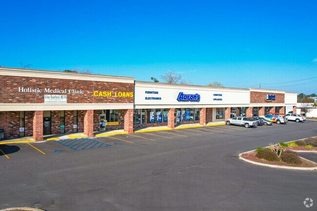
2049 Savannah Hwy, Charleston, SC 29407


Current Lease Availabilities
NEARBY LISTINGS FOR SALE OR LEASE
Property Detail
2049 Savannah Hwy
310-08-00-010
Mapplatp Island
Storebuilding
MAPPLATB L17 MAPPLATP 0012 SUBDIVISIONNAME WEST ISLAND CENTER TRACT A-1
AE
Charleston
45019C0491K
South Carolina
2025
3.89 AC
2024
West Ashley
002801
Charleston/N Charleston
45,400 SF
Charleston-North Charleston, SC
DEMOGRAPHICS near 2049 Savannah Hwy
1 Mile
3 Mile
5 Mile
2024 Total Population
7,236
53,230
122,724
2029 Population
7,662
56,729
130,952
Pop Growth 2024-2029
+ 5.89%
+ 6.57%
+ 6.70%
Average Age
41
40
40
2024 Total Households
3,374
24,667
54,034
HH Growth 2024-2029
+ 5.72%
+ 6.39%
+ 6.55%
Median Household Inc
$68,912
$69,360
$73,794
Avg Household Size
2.10
2.10
2.20
2024 Avg HH Vehicles
2.00
2.00
2.00
Median Home Value
$293,261
$340,824
$351,595
Median Year Built
1976
1980
1984
Nearby Places
Map Layers
Map Styles
 Street
 Aerial
- Restaurants
- Banks
- Shops
- Fitness
- Groceries
PUBLIC TRANSPORTATION
COMMUTER RAIL
Charleston Amtrak Station (Palmetto - Amtrak, Silver Meteor - Amtrak)
DRIVE
WALK
Distance
Charleston Amtrak Station (Palmetto - Amtrak, Silver Meteor - Amtrak)
13 min
7.9 mi
AIRPORT
Charleston AFB/International
DRIVE
WALK
Distance
Charleston AFB/International
16 min
11.0 mi
Freight Ports
Columbus Street Terminal
DRIVE
WALK
Distance
Columbus Street Terminal
13 min
6.5 mi
Nearby Properties
Address
Land Use
TOTAL SIZE
Lot Size
Zoning
Address
Land Use
TOTAL SIZE
Lot Size
Zoning
9,778 SF
11.90 AC
Address
Land Use
TOTAL SIZE
Lot Size
Zoning
21,900 SF
5.96 AC
Address
Land Use
TOTAL SIZE
Lot Size
Zoning
Address
Land Use
TOTAL SIZE
Lot Size
Zoning
11,631 SF
8 AC
Address
Land Use
TOTAL SIZE
Lot Size
Zoning
78,810 SF
3.33 AC
Address
Land Use
TOTAL SIZE
Lot Size
Zoning
6,036 SF
8.79 AC
Address
Land Use
TOTAL SIZE
Lot Size
Zoning
5.54 AC
Address
Land Use
TOTAL SIZE
Lot Size
Zoning
30,196 SF
1.58 AC
Address
Land Use
TOTAL SIZE
Lot Size
Zoning
3,275 SF
4.18 AC
Address
Land Use
TOTAL SIZE
Lot Size
Zoning
6,531 SF
3.11 AC
Address
Land Use
TOTAL SIZE
Lot Size
Zoning
3,520 SF
7.70 AC
Address
Land Use
TOTAL SIZE
Lot Size
Zoning
55.08 AC
Address
Land Use
TOTAL SIZE
Lot Size
Zoning
26,010 SF
4.32 AC
Address
Land Use
TOTAL SIZE
Lot Size
Zoning
7.09 AC
Address
Land Use
TOTAL SIZE
Lot Size
Zoning
34,609 SF
3.57 AC
Address
Land Use
TOTAL SIZE
Lot Size
Zoning
25,749 SF
2.49 AC
Address
Land Use
TOTAL SIZE
Lot Size
Zoning
Address
Land Use
TOTAL SIZE
Lot Size
Zoning
75,984 SF
2.15 AC
Address
Land Use
TOTAL SIZE
Lot Size
Zoning
11,300 SF
25.42 AC
Address
Land Use
TOTAL SIZE
Lot Size
Zoning
18,500 SF
0.90 AC
Address
Land Use
TOTAL SIZE
Lot Size
Zoning
7,492 SF
9.54 AC
Address
Land Use
TOTAL SIZE
Lot Size
Zoning
17.22 AC
Address
Land Use
TOTAL SIZE
Lot Size
Zoning
11,625 SF
9.17 AC
Address
Land Use
TOTAL SIZE
Lot Size
Zoning
11,840 SF
9.66 AC
Address
Land Use
TOTAL SIZE
Lot Size
Zoning
33,756 SF
2.52 AC
Address
Land Use
TOTAL SIZE
Lot Size
Zoning
4,060 SF
27.84 AC
Address
Land Use
TOTAL SIZE
Lot Size
Zoning
1,565 SF
0.46 AC
Address
Land Use
TOTAL SIZE
Lot Size
Zoning
Address
Land Use
TOTAL SIZE
Lot Size
Zoning
105,816 SF
16.34 AC
Address
Land Use
TOTAL SIZE
Lot Size
Zoning
35.14 AC
The World's #1 Commercial Real Estate Marketplace
Connect with us
© 2026 CoStar Group
The information above has been obtained from sources believed reliable. While we do not doubt its accuracy we have not verified it and make no guarantee, warranty or representation about it. It is your responsibility to independently confirm its accuracy and completeness. Any projections, opinions, assumptions, or estimates used are for example only and do not represent the current or future performance of the property. The value of this transaction to you depends on tax and other factors which should be evaluated by your tax, financial, and legal advisors. You and your advisors should conduct a careful, independent investigation of the property to determine to your satisfaction the suitability of the property for your needs.