Property Record
20491 Carancho Rd, Temecula, CA 92590
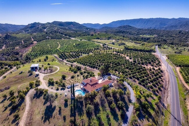

Property Detail
20491 Carancho Rd
933-070-052
8.86 ACRES M/L IN POR PAR 16 PM 004/076
Agriculturalland
RIVERSIDE
A110
California
D Areas with possible but undetermined flood hazards.
16
2024
8.86 AC
2025
South Riverside
049702
Inland Empire (California)
3,474 SF
Riverside-San Bernardino-Ontario, CA
NEARBY LISTINGS FOR SALE OR LEASE
DEMOGRAPHICS near 20491 Carancho Rd
1 mile
3 mile
5 mile
2025 Total Population
158
910
4,416
2030 Population
162
928
4,505
Pop Growth 2025-2030
+ 2.53%
+ 1.98%
+ 2.02%
Average Age
44
43
44
2025 Total Households
55
318
1,515
HH Growth 2025-2030
+ 1.82%
+ 1.57%
+ 1.58%
Median Household Inc
$161,538
$136,428
$140,986
Avg Household Size
2.80
2.80
2.80
2025 Avg HH Vehicles
3.00
3.00
3.00
Median Home Value
$1,079,412
$1,078,221
$1,077,073
Median Year Built
1994
1995
1995
Nearby Places
Map Layers
Map Styles
 Street
 Aerial
Layers
 Traffic
 Biking
Places
Listings with unknown addresses are not visible on the map
- Restaurants
- Banks
- Shops
- Fitness
- Groceries
SALE & LEASE HISTORY
LISTING DATE
SALE/LEASE

Oct 29, 2024
For Sale
Feb 01, 2024
For Sale
Nearby Properties
Address
Land Use
TOTAL SIZE
Lot Size
Zoning
Address
Land Use
TOTAL SIZE
Lot Size
Zoning
15,709 SF
9.01 AC
RA
Address
Land Use
TOTAL SIZE
Lot Size
Zoning
8,886 SF
18.99 AC
RR
Address
Land Use
TOTAL SIZE
Lot Size
Zoning
9,686 SF
9.78 AC
A1
Address
Land Use
TOTAL SIZE
Lot Size
Zoning
8,615 SF
21.75 AC
RA20
Address
Land Use
TOTAL SIZE
Lot Size
Zoning
5,252 SF
19.95 AC
RA10
Address
Land Use
TOTAL SIZE
Lot Size
Zoning
5,946 SF
10.51 AC
RA
Address
Land Use
TOTAL SIZE
Lot Size
Zoning
11,584 SF
23.17 AC
A120
Address
Land Use
TOTAL SIZE
Lot Size
Zoning
2,734 SF
30.28 AC
A70
Address
Land Use
TOTAL SIZE
Lot Size
Zoning
11,688 SF
19.31 AC
A1-20
Address
Land Use
TOTAL SIZE
Lot Size
Zoning
5,796 SF
18.95 AC
RA20
Address
Land Use
TOTAL SIZE
Lot Size
Zoning
6,791 SF
9.82 AC
RA
Address
Land Use
TOTAL SIZE
Lot Size
Zoning
7,025 SF
20.16 AC
A120
Address
Land Use
TOTAL SIZE
Lot Size
Zoning
5,599 SF
8.99 AC
A120
Address
Land Use
TOTAL SIZE
Lot Size
Zoning
10,777 SF
10.44 AC
RA5
Address
Land Use
TOTAL SIZE
Lot Size
Zoning
5,877 SF
5.41 AC
RA5
Address
Land Use
TOTAL SIZE
Lot Size
Zoning
6,353 SF
11.38 AC
A1
Address
Land Use
TOTAL SIZE
Lot Size
Zoning
5,624 SF
11.32 AC
RA
Address
Land Use
TOTAL SIZE
Lot Size
Zoning
1,040 SF
46.15 AC
RA10
Address
Land Use
TOTAL SIZE
Lot Size
Zoning
2,268 SF
41.10 AC
A70
Address
Land Use
TOTAL SIZE
Lot Size
Zoning
3,260 SF
40.04 AC
RA
Address
Land Use
TOTAL SIZE
Lot Size
Zoning
10,353 SF
18.86 AC
RA
Address
Land Use
TOTAL SIZE
Lot Size
Zoning
4,049 SF
13.86 AC
RR
Address
Land Use
TOTAL SIZE
Lot Size
Zoning
4,456 SF
11.01 AC
RA5
Address
Land Use
TOTAL SIZE
Lot Size
Zoning
23.75 AC
A120
Address
Land Use
TOTAL SIZE
Lot Size
Zoning
5,801 SF
9.22 AC
RA10
Address
Land Use
TOTAL SIZE
Lot Size
Zoning
5,038 SF
9.90 AC
A1
Address
Land Use
TOTAL SIZE
Lot Size
Zoning
6,851 SF
11.64 AC
RA5
Address
Land Use
TOTAL SIZE
Lot Size
Zoning
4,315 SF
19.34 AC
A1
Address
Land Use
TOTAL SIZE
Lot Size
Zoning
9,353 SF
9.48 AC
RR
The World's #1 Commercial Real Estate Marketplace
Connect with us
© 2026 CoStar Group
The information above has been obtained from sources believed reliable. While we do not doubt its accuracy we have not verified it and make no guarantee, warranty or representation about it. It is your responsibility to independently confirm its accuracy and completeness. Any projections, opinions, assumptions, or estimates used are for example only and do not represent the current or future performance of the property. The value of this transaction to you depends on tax and other factors which should be evaluated by your tax, financial, and legal advisors. You and your advisors should conduct a careful, independent investigation of the property to determine to your satisfaction the suitability of the property for your needs.