Property Record
205 Dry River Rd, Bridgewater, VA 22812
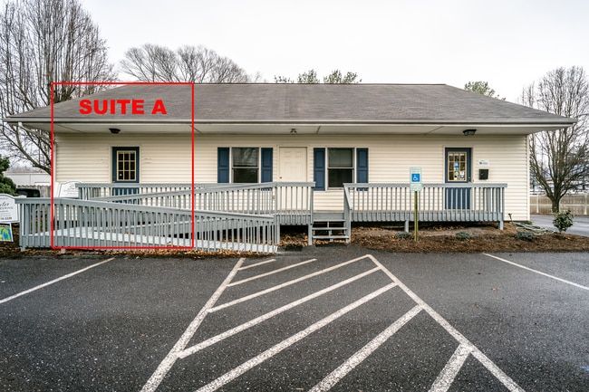

Property Detail
205 Dry River Rd
122A2-A-L2F
DRY RIVER RD
Officebuilding
Rockingham
M1
Virginia
2026
0.40 AC
2026
Staunton & Harrisonburg
011500
Other Market Areas
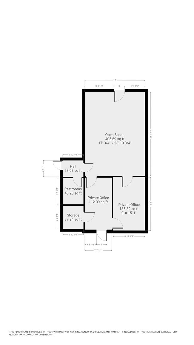
4,400 SF
Harrisonburg, VA
NEARBY LISTINGS FOR SALE OR LEASE
DEMOGRAPHICS near 205 Dry River Rd
1 mile
3 mile
5 mile
2025 Total Population
5,443
11,211
21,189
2030 Population
5,643
11,582
21,791
Pop Growth 2025-2030
+ 3.67%
+ 3.31%
+ 2.84%
Average Age
40
40
39
2025 Total Households
1,927
3,831
7,477
HH Growth 2025-2030
+ 3.94%
+ 3.47%
+ 2.90%
Median Household Inc
$81,007
$85,209
$82,545
Avg Household Size
2.30
2.40
2.60
2025 Avg HH Vehicles
2.00
2.00
2.00
Median Home Value
$361,604
$360,759
$357,164
Median Year Built
1981
1979
1987
Nearby Places
Map Layers
Map Styles
 Street
 Aerial
Layers
 Traffic
 Biking
Places
Listings with unknown addresses are not visible on the map
- Restaurants
- Banks
- Shops
- Fitness
- Groceries
SALE & LEASE HISTORY
LISTING DATE
SALE/LEASE

Jan 12, 2022
For Lease
Nearby Properties
Address
Land Use
TOTAL SIZE
Lot Size
Zoning
Address
Land Use
TOTAL SIZE
Lot Size
Zoning
25,038 SF
56.59 AC
R1
Address
Land Use
TOTAL SIZE
Lot Size
Zoning
57.92 AC
I1
Address
Land Use
TOTAL SIZE
Lot Size
Zoning
260,792 SF
27.98 AC
P1
Address
Land Use
TOTAL SIZE
Lot Size
Zoning
4,842 SF
7.07 AC
R3
Address
Land Use
TOTAL SIZE
Lot Size
Zoning
7,464 SF
74.63 AC
I1
Address
Land Use
TOTAL SIZE
Lot Size
Zoning
130,426 SF
19.11 AC
R1
Address
Land Use
TOTAL SIZE
Lot Size
Zoning
16.52 AC
TOWN
Address
Land Use
TOTAL SIZE
Lot Size
Zoning
295,544 SF
33.23 AC
I1
Address
Land Use
TOTAL SIZE
Lot Size
Zoning
21.42 AC
I1
Address
Land Use
TOTAL SIZE
Lot Size
Zoning
4.82 AC
B1
Address
Land Use
TOTAL SIZE
Lot Size
Zoning
74,032 SF
20.64 AC
R3
Address
Land Use
TOTAL SIZE
Lot Size
Zoning
36,612 SF
12.78 AC
R3
Address
Land Use
TOTAL SIZE
Lot Size
Zoning
100,393 SF
18.03 AC
B1
Address
Land Use
TOTAL SIZE
Lot Size
Zoning
6,001 SF
10 AC
I1
Address
Land Use
TOTAL SIZE
Lot Size
Zoning
28,452 SF
0.20 AC
R3
Address
Land Use
TOTAL SIZE
Lot Size
Zoning
3.69 AC
M1
Address
Land Use
TOTAL SIZE
Lot Size
Zoning
3.63 AC
A2
Address
Land Use
TOTAL SIZE
Lot Size
Zoning
Address
Land Use
TOTAL SIZE
Lot Size
Zoning
53,524 SF
4.16 AC
R1
Address
Land Use
TOTAL SIZE
Lot Size
Zoning
16,300 SF
10 AC
A2
Address
Land Use
TOTAL SIZE
Lot Size
Zoning
21,920 SF
6.40 AC
A2
Address
Land Use
TOTAL SIZE
Lot Size
Zoning
23,071 SF
8.19 AC
B2
Address
Land Use
TOTAL SIZE
Lot Size
Zoning
20,160 SF
15.73 AC
P1
Address
Land Use
TOTAL SIZE
Lot Size
Zoning
56,761 SF
6.96 AC
A2
Address
Land Use
TOTAL SIZE
Lot Size
Zoning
24,825 SF
6 AC
B1
Address
Land Use
TOTAL SIZE
Lot Size
Zoning
14,476 SF
10 AC
I1
Address
Land Use
TOTAL SIZE
Lot Size
Zoning
15,337 SF
8.61 AC
B1
Address
Land Use
TOTAL SIZE
Lot Size
Zoning
38,989 SF
8.70 AC
A2
Address
Land Use
TOTAL SIZE
Lot Size
Zoning
17,545 SF
2.33 AC
R1
Address
Land Use
TOTAL SIZE
Lot Size
Zoning
23,080 SF
0.70 AC
R1
The World's #1 Commercial Real Estate Marketplace
Connect with us
© 2026 CoStar Group
The information above has been obtained from sources believed reliable. While we do not doubt its accuracy we have not verified it and make no guarantee, warranty or representation about it. It is your responsibility to independently confirm its accuracy and completeness. Any projections, opinions, assumptions, or estimates used are for example only and do not represent the current or future performance of the property. The value of this transaction to you depends on tax and other factors which should be evaluated by your tax, financial, and legal advisors. You and your advisors should conduct a careful, independent investigation of the property to determine to your satisfaction the suitability of the property for your needs.