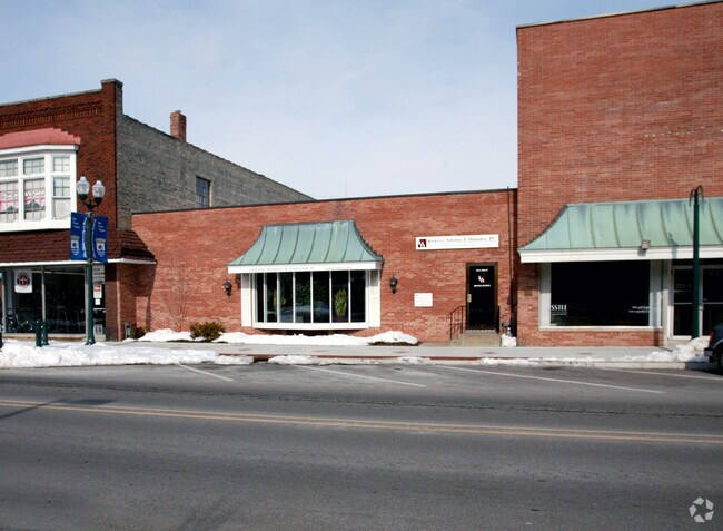
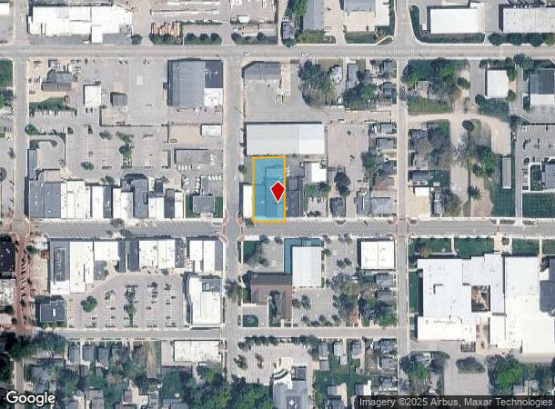
Property Record
205 E Main Ave, Zeeland, MI 49464
NEARBY LISTINGS FOR SALE OR LEASE
-
-
View all Zeeland listings for sale on LoopNet.com
Property Detail
205 E Main Ave
70-17-18-398-045
PART OF SW 1/4 COM SW SEC COR, TH N 89D 54M 29S E 139382 FT ALG S SEC LI & N 0D 36M 30S E 5712 FT TO N LI MAIN ST & PT OF
Retailwithmorethanonenonretailuse
Ottawa
X
Michigan
26005C0050G
0.45 AC
2025
Zeeland
2025
West Michigan
022900
Grand Rapids-Wyoming-Kentwood, MI
18,424 SF
DEMOGRAPHICS near 205 E Main Ave
1 Mile
3 Mile
5 Mile
2024 Total Population
7,388
26,974
54,215
2029 Population
7,662
28,107
56,575
Pop Growth 2024-2029
+ 3.71%
+ 4.20%
+ 4.35%
Average Age
40
39
38
2024 Total Households
2,855
9,716
19,871
HH Growth 2024-2029
+ 3.85%
+ 4.33%
+ 4.56%
Median Household Inc
$73,946
$85,257
$76,714
Avg Household Size
2.50
2.70
2.60
2024 Avg HH Vehicles
2.00
2.00
2.00
Median Home Value
$238,023
$254,454
$248,452
Median Year Built
1975
1992
1991
Nearby Places
Map Layers
Map Styles
 Street
 Aerial
- Restaurants
- Banks
- Shops
- Fitness
- Groceries
PUBLIC TRANSPORTATION
COMMUTER RAIL
Holland Amtrak Station (Pere Marquette - Amtrak)
DRIVE
WALK
Distance
Holland Amtrak Station (Pere Marquette - Amtrak)
9 min
5.2 mi
AIRPORT
Gerald R Ford International
DRIVE
WALK
Distance
Gerald R Ford International
38 min
29.1 mi
Freight Ports
Port Milwaukee
DRIVE
WALK
Distance
Port Milwaukee
282 min
241.1 mi
Nearby Properties
Address
Land Use
TOTAL SIZE
Lot Size
Zoning
Address
Land Use
TOTAL SIZE
Lot Size
Zoning
1,134,118 SF
73.70 AC
I-2
Address
Land Use
TOTAL SIZE
Lot Size
Zoning
255,407 SF
23.18 AC
I-2
Address
Land Use
TOTAL SIZE
Lot Size
Zoning
349,583 SF
I
Address
Land Use
TOTAL SIZE
Lot Size
Zoning
662,015 SF
177 AC
SEE MAP
Address
Land Use
TOTAL SIZE
Lot Size
Zoning
716,625 SF
123.22 AC
I-2
Address
Land Use
TOTAL SIZE
Lot Size
Zoning
249,051 SF
24.77 AC
LDR
Address
Land Use
TOTAL SIZE
Lot Size
Zoning
594,031 SF
R-1
Address
Land Use
TOTAL SIZE
Lot Size
Zoning
218,722 SF
8.59 AC
AGR
Address
Land Use
TOTAL SIZE
Lot Size
Zoning
82,556 SF
Address
Land Use
TOTAL SIZE
Lot Size
Zoning
259,200 SF
R-1
Address
Land Use
TOTAL SIZE
Lot Size
Zoning
6,000 SF
46.50 AC
I-2
Address
Land Use
TOTAL SIZE
Lot Size
Zoning
226,347 SF
19.44 AC
I-2
Address
Land Use
TOTAL SIZE
Lot Size
Zoning
173,176 SF
28.57 AC
I-1
Address
Land Use
TOTAL SIZE
Lot Size
Zoning
132,127 SF
42.69 AC
SEE MAP
Address
Land Use
TOTAL SIZE
Lot Size
Zoning
35,715 SF
Address
Land Use
TOTAL SIZE
Lot Size
Zoning
230,020 SF
Address
Land Use
TOTAL SIZE
Lot Size
Zoning
109,988 SF
12.71 AC
OS-1
Address
Land Use
TOTAL SIZE
Lot Size
Zoning
184,944 SF
12.57 AC
R-3
Address
Land Use
TOTAL SIZE
Lot Size
Zoning
3,880 SF
80 AC
RMH
Address
Land Use
TOTAL SIZE
Lot Size
Zoning
77,624 SF
27.32 AC
I-1
Address
Land Use
TOTAL SIZE
Lot Size
Zoning
50,000 SF
20.36 AC
I-2
Address
Land Use
TOTAL SIZE
Lot Size
Zoning
181,847 SF
12.99 AC
I-1
Address
Land Use
TOTAL SIZE
Lot Size
Zoning
376,204 SF
20.10 AC
I-1
Address
Land Use
TOTAL SIZE
Lot Size
Zoning
19,966 SF
Address
Land Use
TOTAL SIZE
Lot Size
Zoning
49,013 SF
11.76 AC
C-2
Address
Land Use
TOTAL SIZE
Lot Size
Zoning
88,093 SF
Address
Land Use
TOTAL SIZE
Lot Size
Zoning
243,795 SF
17.31 AC
AG
Address
Land Use
TOTAL SIZE
Lot Size
Zoning
Address
Land Use
TOTAL SIZE
Lot Size
Zoning
152,027 SF
14.10 AC
I-2
Address
Land Use
TOTAL SIZE
Lot Size
Zoning
220,885 SF
10 AC
I-2
The World's #1 Commercial Real Estate Marketplace
Connect with us
© 2026 CoStar Group
The information above has been obtained from sources believed reliable. While we do not doubt its accuracy we have not verified it and make no guarantee, warranty or representation about it. It is your responsibility to independently confirm its accuracy and completeness. Any projections, opinions, assumptions, or estimates used are for example only and do not represent the current or future performance of the property. The value of this transaction to you depends on tax and other factors which should be evaluated by your tax, financial, and legal advisors. You and your advisors should conduct a careful, independent investigation of the property to determine to your satisfaction the suitability of the property for your needs.