Property Record
205 E Main St, Brownsburg, IN 46112
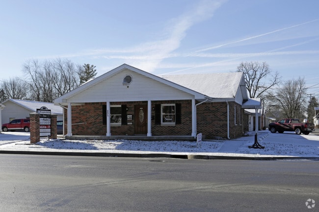
Property Detail
205 E Main St
Indianapolis-Carmel-Greenwood, IN
MORTON GREENS ADDITION LOT 1 PT LOT 2 0.41 AC BLOCK 8 DBA; PB LOGISTICS SERVICES LLC, MINDYS BROWNSBURG SIGNS INC, MAIN ST. V
32-07-11-315-058.000-016
Hendricks
Storebuilding
Indiana
B and X Area of moderate flood hazard, usually the area between the limits of the 100-year and 500-year floods.
1,2
2025
0.41 AC
2025
Hendricks County
210203
Indianapolis
5,676 SF
NEARBY LISTINGS FOR SALE OR LEASE
DEMOGRAPHICS near 205 E Main St
1 mile
3 mile
5 mile
2025 Total Population
9,352
45,469
87,329
2030 Population
10,061
49,023
93,622
Pop Growth 2025-2030
+ 7.58%
+ 7.82%
+ 7.21%
Average Age
40
39
39
2025 Total Households
3,887
16,674
31,707
HH Growth 2025-2030
+ 7.85%
+ 8.05%
+ 7.37%
Median Household Inc
$82,617
$108,659
$109,217
Avg Household Size
2.30
2.70
2.70
2025 Avg HH Vehicles
2.00
2.00
2.00
Median Home Value
$247,816
$322,777
$326,494
Median Year Built
1989
1999
2000
Nearby Places
Map Layers
Map Styles
 Street
 Aerial
Layers
 Traffic
 Biking
Places
Listings with unknown addresses are not visible on the map
- Restaurants
- Banks
- Shops
- Fitness
- Groceries
PUBLIC TRANSPORTATION
AIRPORT
Indianapolis International
Drive
Walk
Distance
Indianapolis International
29 min
15.1 mi
SALE & LEASE HISTORY
LISTING DATE
SALE/LEASE

Jan 31, 2017
For Lease
Nearby Properties
Address
Land Use
TOTAL SIZE
Lot Size
Zoning
Address
Land Use
TOTAL SIZE
Lot Size
Zoning
56.57 AC
Address
Land Use
TOTAL SIZE
Lot Size
Zoning
805,018 SF
48.20 AC
Address
Land Use
TOTAL SIZE
Lot Size
Zoning
683,528 SF
43.54 AC
Address
Land Use
TOTAL SIZE
Lot Size
Zoning
456 SF
50.27 AC
Address
Land Use
TOTAL SIZE
Lot Size
Zoning
773,129 SF
36.12 AC
Address
Land Use
TOTAL SIZE
Lot Size
Zoning
54,586 SF
5.84 AC
Address
Land Use
TOTAL SIZE
Lot Size
Zoning
25,031 SF
20.30 AC
Address
Land Use
TOTAL SIZE
Lot Size
Zoning
Address
Land Use
TOTAL SIZE
Lot Size
Zoning
26,460 SF
24.91 AC
Address
Land Use
TOTAL SIZE
Lot Size
Zoning
32.50 AC
Address
Land Use
TOTAL SIZE
Lot Size
Zoning
244,838 SF
3.01 AC
Address
Land Use
TOTAL SIZE
Lot Size
Zoning
225,712 SF
2.22 AC
Address
Land Use
TOTAL SIZE
Lot Size
Zoning
3,712 SF
17.58 AC
Address
Land Use
TOTAL SIZE
Lot Size
Zoning
526,200 SF
28.31 AC
Address
Land Use
TOTAL SIZE
Lot Size
Zoning
405,824 SF
32.37 AC
Address
Land Use
TOTAL SIZE
Lot Size
Zoning
396,768 SF
20.88 AC
Address
Land Use
TOTAL SIZE
Lot Size
Zoning
86,706 SF
19.47 AC
Address
Land Use
TOTAL SIZE
Lot Size
Zoning
Address
Land Use
TOTAL SIZE
Lot Size
Zoning
Address
Land Use
TOTAL SIZE
Lot Size
Zoning
204,358 SF
12.50 AC
Address
Land Use
TOTAL SIZE
Lot Size
Zoning
100,108 SF
50.12 AC
Address
Land Use
TOTAL SIZE
Lot Size
Zoning
80,046 SF
13.65 AC
Address
Land Use
TOTAL SIZE
Lot Size
Zoning
20.46 AC
Address
Land Use
TOTAL SIZE
Lot Size
Zoning
7,568 SF
14.47 AC
Address
Land Use
TOTAL SIZE
Lot Size
Zoning
Address
Land Use
TOTAL SIZE
Lot Size
Zoning
99,038 SF
7.09 AC
Address
Land Use
TOTAL SIZE
Lot Size
Zoning
17,500 SF
33.72 AC
Address
Land Use
TOTAL SIZE
Lot Size
Zoning
Address
Land Use
TOTAL SIZE
Lot Size
Zoning
75,809 SF
7.91 AC
Address
Land Use
TOTAL SIZE
Lot Size
Zoning
5,934 SF
9.78 AC
The World's #1 Commercial Real Estate Marketplace
Connect with us
© 2026 CoStar Group
The information above has been obtained from sources believed reliable. While we do not doubt its accuracy we have not verified it and make no guarantee, warranty or representation about it. It is your responsibility to independently confirm its accuracy and completeness. Any projections, opinions, assumptions, or estimates used are for example only and do not represent the current or future performance of the property. The value of this transaction to you depends on tax and other factors which should be evaluated by your tax, financial, and legal advisors. You and your advisors should conduct a careful, independent investigation of the property to determine to your satisfaction the suitability of the property for your needs.