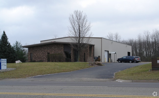
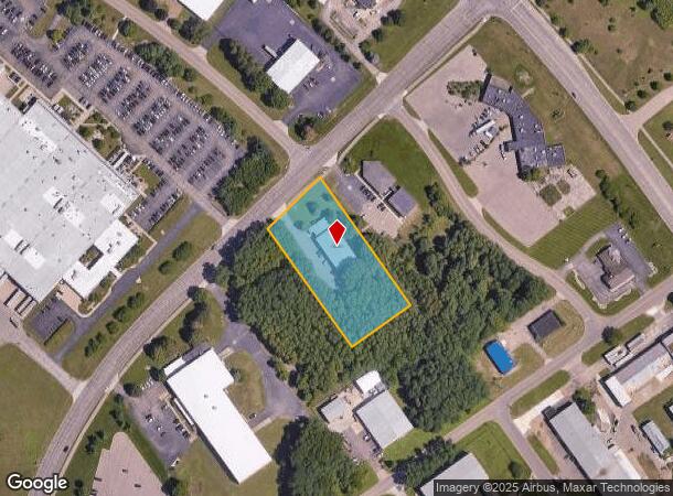
Property Record
205 Hill Brady Rd, Battle Creek, MI 49037
NEARBY LISTINGS FOR SALE OR LEASE
Property Detail
205 Hill Brady Rd
Battle Creek, MI
Battle Creek Fort Urban Renewal Plat
3020-01-050-0
BC ? FORT CUSTER URBAN RENEWAL PLAT LOT 50
Manufacturinglight
Calhoun
X
Michigan
26077C0250E
50
0
1.73 AC
2025
Battle Crk/W Calhoun Cnty
002600
West Michigan
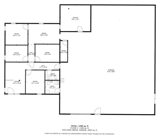
7,200 SF
DEMOGRAPHICS near 205 Hill Brady Rd
1 Mile
3 Mile
5 Mile
2024 Total Population
2,072
14,338
44,007
2029 Population
2,047
14,207
43,663
Pop Growth 2024-2029
(1.21%)
(0.91%)
(0.78%)
Average Age
36
40
39
2024 Total Households
856
6,128
18,024
HH Growth 2024-2029
(1.29%)
(1.00%)
(0.85%)
Median Household Inc
$31,059
$45,442
$46,751
Avg Household Size
2.00
2.20
2.30
2024 Avg HH Vehicles
1.00
2.00
2.00
Median Home Value
$94,999
$105,254
$107,835
Median Year Built
1976
1963
1957
Nearby Places
Map Layers
Map Styles
 Street
 Aerial
- Restaurants
- Banks
- Shops
- Fitness
- Groceries
PUBLIC TRANSPORTATION
COMMUTER RAIL
DRIVE
WALK
Distance
9 min
5.3 mi
AIRPORT
Kalamazoo/Battle Creek International
DRIVE
WALK
Distance
Kalamazoo/Battle Creek International
34 min
19.8 mi
SALE & LEASE HISTORY
LISTING DATE
SALE/LEASE

Feb 28, 2023
For Lease
Apr 27, 2022
For Sale
Nearby Properties
Address
Land Use
TOTAL SIZE
Lot Size
Zoning
Address
Land Use
TOTAL SIZE
Lot Size
Zoning
1,279,617 SF
86.82 AC
I2
Address
Land Use
TOTAL SIZE
Lot Size
Zoning
183,198 SF
17.72 AC
RM-1
Address
Land Use
TOTAL SIZE
Lot Size
Zoning
123,060 SF
10.53 AC
I2
Address
Land Use
TOTAL SIZE
Lot Size
Zoning
415,320 SF
50.04 AC
I2
Address
Land Use
TOTAL SIZE
Lot Size
Zoning
308,111 SF
50.82 AC
I2
Address
Land Use
TOTAL SIZE
Lot Size
Zoning
111,002 SF
AG
Address
Land Use
TOTAL SIZE
Lot Size
Zoning
188,711 SF
44.81 AC
I2
Address
Land Use
TOTAL SIZE
Lot Size
Zoning
308,395 SF
24.34 AC
I2
Address
Land Use
TOTAL SIZE
Lot Size
Zoning
191,315 SF
11.29 AC
I2
Address
Land Use
TOTAL SIZE
Lot Size
Zoning
150,018 SF
13.12 AC
MFR
Address
Land Use
TOTAL SIZE
Lot Size
Zoning
113,070 SF
6.35 AC
MFR
Address
Land Use
TOTAL SIZE
Lot Size
Zoning
191,099 SF
29.08 AC
I2
Address
Land Use
TOTAL SIZE
Lot Size
Zoning
199,664 SF
24.70 AC
I2
Address
Land Use
TOTAL SIZE
Lot Size
Zoning
96,142 SF
13.73 AC
MFR
Address
Land Use
TOTAL SIZE
Lot Size
Zoning
161,104 SF
38.28 AC
I2
Address
Land Use
TOTAL SIZE
Lot Size
Zoning
217,678 SF
21.03 AC
I2
Address
Land Use
TOTAL SIZE
Lot Size
Zoning
196,225 SF
17.73 AC
I2
Address
Land Use
TOTAL SIZE
Lot Size
Zoning
94,222 SF
I2
Address
Land Use
TOTAL SIZE
Lot Size
Zoning
43,780 SF
I2
Address
Land Use
TOTAL SIZE
Lot Size
Zoning
127,365 SF
9 AC
I2
Address
Land Use
TOTAL SIZE
Lot Size
Zoning
111,744 SF
9.75 AC
RM-1
Address
Land Use
TOTAL SIZE
Lot Size
Zoning
95,666 SF
46.56 AC
I1
Address
Land Use
TOTAL SIZE
Lot Size
Zoning
99,816 SF
22.44 AC
I2
Address
Land Use
TOTAL SIZE
Lot Size
Zoning
239,876 SF
30.39 AC
I2
Address
Land Use
TOTAL SIZE
Lot Size
Zoning
123,918 SF
24.50 AC
I2
Address
Land Use
TOTAL SIZE
Lot Size
Zoning
123,544 SF
17.11 AC
I2
Address
Land Use
TOTAL SIZE
Lot Size
Zoning
157,819 SF
21.09 AC
I2
Address
Land Use
TOTAL SIZE
Lot Size
Zoning
85,800 SF
Address
Land Use
TOTAL SIZE
Lot Size
Zoning
50,000 SF
8.48 AC
R-2
Address
Land Use
TOTAL SIZE
Lot Size
Zoning
35,436 SF
4.52 AC
I INDUS
The World's #1 Commercial Real Estate Marketplace
Connect with us
© 2025 CoStar Group
The information above has been obtained from sources believed reliable. While we do not doubt its accuracy we have not verified it and make no guarantee, warranty or representation about it. It is your responsibility to independently confirm its accuracy and completeness. Any projections, opinions, assumptions, or estimates used are for example only and do not represent the current or future performance of the property. The value of this transaction to you depends on tax and other factors which should be evaluated by your tax, financial, and legal advisors. You and your advisors should conduct a careful, independent investigation of the property to determine to your satisfaction the suitability of the property for your needs.