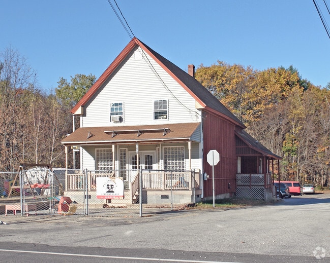
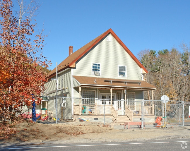
Property Record
205 Main St, Plaistow, NH 03865
Save to a Folder
{{folder.Name}}
{{folder.ListingIds.length}} Properties
{{folder.ListingIds.length}} Property
Create a New Folder
Property Detail
205 Main St
PLSW-000030-000058
Rockingham
Autorepair
New Hampshire
C-3
000
B and X Area of moderate flood hazard, usually the area between the limits of the 100-year and 500-year floods.
1.14 AC
2025
Rockingham
2025
Boston
101102
Boston-Cambridge-Newton, MA-NH
4,500 SF
NEARBY LISTINGS FOR SALE OR LEASE
DEMOGRAPHICS near 205 Main St
1 mile
3 mile
5 mile
2025 Total Population
536
4,357
13,938
2030 Population
539
4,382
14,111
Pop Growth 2025-2030
+ 0.56%
+ 0.57%
+ 1.24%
Average Age
46
45
44
2025 Total Households
204
1,641
5,164
HH Growth 2025-2030
+ 0.49%
+ 0.49%
+ 1.18%
Median Household Inc
$122,368
$125,977
$129,345
Avg Household Size
2.60
2.70
2.70
2025 Avg HH Vehicles
3.00
3.00
2.00
Median Home Value
$437,255
$457,329
$461,715
Median Year Built
1975
1977
1981
Nearby Places
Map Layers
Map Styles
 Street
 Aerial
Layers
 Traffic
 Biking
Places
Listings with unknown addresses are not visible on the map
- Restaurants
- Banks
- Shops
- Fitness
- Groceries
PUBLIC TRANSPORTATION
COMMUTER RAIL
Haverhill (Haverhill Line - Massachusetts Bay Transportation Authority Commuter Rail (Purple Line))
Drive
Walk
Distance
Haverhill (Haverhill Line - Massachusetts Bay Transportation Authority Commuter Rail (Purple Line))
12 min
6.3 mi
Bradford (Haverhill Line - Massachusetts Bay Transportation Authority Commuter Rail (Purple Line))
Drive
Walk
Distance
Bradford (Haverhill Line - Massachusetts Bay Transportation Authority Commuter Rail (Purple Line))
13 min
6.7 mi
AIRPORT
Manchester Boston Regional
Drive
Walk
Distance
Manchester Boston Regional
50 min
29.1 mi
Portsmouth International at Pease
Drive
Walk
Distance
Portsmouth International at Pease
47 min
33.6 mi
Freight Ports
Port of Boston
Drive
Walk
Distance
Port of Boston
58 min
41.8 mi
Nearby Properties
Address
Land Use
TOTAL SIZE
Lot Size
Zoning
Address
Land Use
TOTAL SIZE
Lot Size
Zoning
169,340 SF
14.95 AC
C-1
Address
Land Use
TOTAL SIZE
Lot Size
Zoning
257,286 SF
90 AC
LDR
Address
Land Use
TOTAL SIZE
Lot Size
Zoning
125,627 SF
46.02 AC
C-1
Address
Land Use
TOTAL SIZE
Lot Size
Zoning
35,633 SF
19.15 AC
C-1
Address
Land Use
TOTAL SIZE
Lot Size
Zoning
2,400 SF
4 AC
MDR
Address
Land Use
TOTAL SIZE
Lot Size
Zoning
102,488 SF
19.50 AC
Address
Land Use
TOTAL SIZE
Lot Size
Zoning
89,227 SF
89.88 AC
A-RES
Address
Land Use
TOTAL SIZE
Lot Size
Zoning
115,088 SF
27.42 AC
Address
Land Use
TOTAL SIZE
Lot Size
Zoning
2.09 AC
LDR
Address
Land Use
TOTAL SIZE
Lot Size
Zoning
99,441 SF
18.69 AC
C-1
Address
Land Use
TOTAL SIZE
Lot Size
Zoning
39,670 SF
26.55 AC
RES-A
Address
Land Use
TOTAL SIZE
Lot Size
Zoning
184,193 SF
24.80 AC
I
Address
Land Use
TOTAL SIZE
Lot Size
Zoning
32,074 SF
6.69 AC
C-1
Address
Land Use
TOTAL SIZE
Lot Size
Zoning
67,705 SF
10.93 AC
TC- TO
Address
Land Use
TOTAL SIZE
Lot Size
Zoning
12,187 SF
18.51 AC
A-RES
Address
Land Use
TOTAL SIZE
Lot Size
Zoning
55,960 SF
12.42 AC
I
Address
Land Use
TOTAL SIZE
Lot Size
Zoning
130,422 SF
16.95 AC
LIGHT
Address
Land Use
TOTAL SIZE
Lot Size
Zoning
70,433 SF
30.78 AC
VC
Address
Land Use
TOTAL SIZE
Lot Size
Zoning
79,184 SF
9.96 AC
C-3
Address
Land Use
TOTAL SIZE
Lot Size
Zoning
16,020 SF
6.68 AC
VC
Address
Land Use
TOTAL SIZE
Lot Size
Zoning
61,920 SF
6.27 AC
Address
Land Use
TOTAL SIZE
Lot Size
Zoning
2.10 AC
Address
Land Use
TOTAL SIZE
Lot Size
Zoning
0.64 AC
LDR
Address
Land Use
TOTAL SIZE
Lot Size
Zoning
19,823 SF
2.60 AC
C-1
Address
Land Use
TOTAL SIZE
Lot Size
Zoning
19,120 SF
14.41 AC
C-1
Address
Land Use
TOTAL SIZE
Lot Size
Zoning
13,840 SF
19.80 AC
C-3
Address
Land Use
TOTAL SIZE
Lot Size
Zoning
66,288 SF
50.31 AC
LIGHT
Address
Land Use
TOTAL SIZE
Lot Size
Zoning
48,400 SF
5.75 AC
I
Address
Land Use
TOTAL SIZE
Lot Size
Zoning
27,362 SF
2.51 AC
C-3
Address
Land Use
TOTAL SIZE
Lot Size
Zoning
32,533 SF
9.46 AC
C2 C
The World's #1 Commercial Real Estate Marketplace
Connect with us
© 2026 CoStar Group
The information above has been obtained from sources believed reliable. While we do not doubt its accuracy we have not verified it and make no guarantee, warranty or representation about it. It is your responsibility to independently confirm its accuracy and completeness. Any projections, opinions, assumptions, or estimates used are for example only and do not represent the current or future performance of the property. The value of this transaction to you depends on tax and other factors which should be evaluated by your tax, financial, and legal advisors. You and your advisors should conduct a careful, independent investigation of the property to determine to your satisfaction the suitability of the property for your needs.