Property Record
Mill St, Ecorse, MI 48229
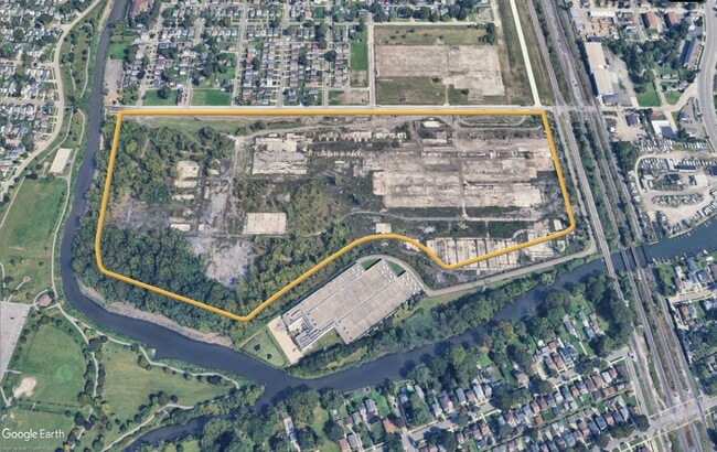
This Property Is For Sale
NEARBY LISTINGS FOR SALE OR LEASE
Property Detail
Mill St
Detroit
River Heights
Detroit-Warren-Dearborn, MI
THAT PART OF PRIVATE CLAIMS 86 AND 212, TOWN 3 SOUTH, RANGE 11 EAST, CITY OF ECORSE, WAYNE COUNTY, MICHIGAN AND ALL OF LOTS 4
34-014-99-0014-002
Wayne
Industrialacreage
Michigan
0
50.59 AC
2025
Downriver South
579700
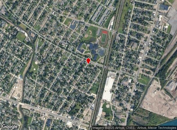
DEMOGRAPHICS near Mill St
1 Mile
3 Mile
5 Mile
2024 Total Population
13,470
99,674
184,193
2029 Population
12,949
95,687
176,206
Pop Growth 2024-2029
(3.87%)
(4.00%)
(4.34%)
Average Age
40
40
40
2024 Total Households
5,302
40,391
74,592
HH Growth 2024-2029
(3.89%)
(4.10%)
(4.37%)
Median Household Inc
$54,563
$54,871
$57,450
Avg Household Size
2.50
2.40
2.40
2024 Avg HH Vehicles
2.00
2.00
2.00
Median Home Value
$123,433
$127,635
$138,508
Median Year Built
1953
1952
1954
Nearby Places
Map Layers
Map Styles
 Street
 Aerial
- Restaurants
- Banks
- Shops
- Fitness
- Groceries
PUBLIC TRANSPORTATION
COMMUTER RAIL
Dearborn (Wolverine - Amtrak)
DRIVE
WALK
Distance
Dearborn (Wolverine - Amtrak)
17 min
7.4 mi
AIRPORT
Detroit Metro Wayne County
DRIVE
WALK
Distance
Detroit Metro Wayne County
24 min
15.6 mi
Windsor International
DRIVE
WALK
Distance
Windsor International
35 min
18.9 mi
Freight Ports
Port of Toledo
DRIVE
WALK
Distance
Port of Toledo
66 min
53.4 mi
Nearby Properties
Address
Land Use
TOTAL SIZE
Lot Size
Zoning
Address
Land Use
TOTAL SIZE
Lot Size
Zoning
1,025,154 SF
233.15 AC
Address
Land Use
TOTAL SIZE
Lot Size
Zoning
7,320 SF
226.49 AC
Address
Land Use
TOTAL SIZE
Lot Size
Zoning
187,395 SF
Address
Land Use
TOTAL SIZE
Lot Size
Zoning
114,157 SF
Address
Land Use
TOTAL SIZE
Lot Size
Zoning
196,801 SF
38.32 AC
M5
Address
Land Use
TOTAL SIZE
Lot Size
Zoning
111,402 SF
3.17 AC
Address
Land Use
TOTAL SIZE
Lot Size
Zoning
193,650 SF
18.39 AC
Address
Land Use
TOTAL SIZE
Lot Size
Zoning
145,572 SF
58.41 AC
M4
Address
Land Use
TOTAL SIZE
Lot Size
Zoning
76,350 SF
0.69 AC
Address
Land Use
TOTAL SIZE
Lot Size
Zoning
130,968 SF
0.84 AC
Address
Land Use
TOTAL SIZE
Lot Size
Zoning
79.03 AC
M2 HEAV
Address
Land Use
TOTAL SIZE
Lot Size
Zoning
351,906 SF
42.21 AC
M4
Address
Land Use
TOTAL SIZE
Lot Size
Zoning
660 SF
41.97 AC
R1 1 FA
Address
Land Use
TOTAL SIZE
Lot Size
Zoning
105,920 SF
12.46 AC
Address
Land Use
TOTAL SIZE
Lot Size
Zoning
45,400 SF
R1 1 FA
Address
Land Use
TOTAL SIZE
Lot Size
Zoning
32,245 SF
23.27 AC
M5
Address
Land Use
TOTAL SIZE
Lot Size
Zoning
105,503 SF
19.83 AC
Address
Land Use
TOTAL SIZE
Lot Size
Zoning
121,912 SF
7.88 AC
Address
Land Use
TOTAL SIZE
Lot Size
Zoning
77,026 SF
9.64 AC
R1 1 FA
Address
Land Use
TOTAL SIZE
Lot Size
Zoning
106.97 AC
M2 HEAV
Address
Land Use
TOTAL SIZE
Lot Size
Zoning
70,100 SF
2.40 AC
C 6C
Address
Land Use
TOTAL SIZE
Lot Size
Zoning
228,000 SF
12.70 AC
Address
Land Use
TOTAL SIZE
Lot Size
Zoning
414,868 SF
26.36 AC
R1 1 FA
Address
Land Use
TOTAL SIZE
Lot Size
Zoning
8,774 SF
29.39 AC
R1 1 FA
Address
Land Use
TOTAL SIZE
Lot Size
Zoning
78,580 SF
0.62 AC
Address
Land Use
TOTAL SIZE
Lot Size
Zoning
2,220 SF
10.66 AC
Address
Land Use
TOTAL SIZE
Lot Size
Zoning
108,000 SF
7.46 AC
Address
Land Use
TOTAL SIZE
Lot Size
Zoning
292,797 SF
9.31 AC
Address
Land Use
TOTAL SIZE
Lot Size
Zoning
182,640 SF
13.98 AC
Address
Land Use
TOTAL SIZE
Lot Size
Zoning
282,489 SF
15.96 AC
The World's #1 Commercial Real Estate Marketplace
Connect with us
© 2025 CoStar Group
The information above has been obtained from sources believed reliable. While we do not doubt its accuracy we have not verified it and make no guarantee, warranty or representation about it. It is your responsibility to independently confirm its accuracy and completeness. Any projections, opinions, assumptions, or estimates used are for example only and do not represent the current or future performance of the property. The value of this transaction to you depends on tax and other factors which should be evaluated by your tax, financial, and legal advisors. You and your advisors should conduct a careful, independent investigation of the property to determine to your satisfaction the suitability of the property for your needs.