Property Record
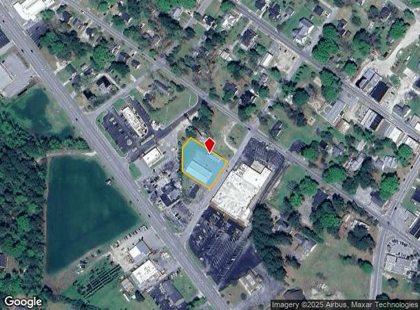
205 S Academy St, Richlands, NC 28574
NEARBY LISTINGS FOR SALE OR LEASE
Property Detail
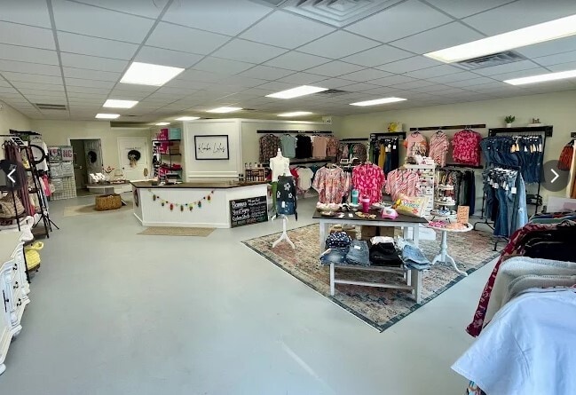
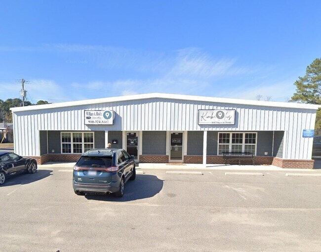
205 S Academy St
031199
ACADEMY ST
Communitycenter
Onslow
X
North Carolina
3720443200K
0.69 AC
2025
North Carolina Southeast Area
2025
Other Market Areas
000207
Jacksonville, NC
4,500 SF
DEMOGRAPHICS near 205 S Academy St
1 Mile
3 Mile
5 Mile
2024 Total Population
1,619
7,093
15,807
2029 Population
1,684
7,362
16,525
Pop Growth 2024-2029
+ 4.01%
+ 3.79%
+ 4.54%
Average Age
35
33
33
2024 Total Households
624
2,498
5,529
HH Growth 2024-2029
+ 4.33%
+ 4.16%
+ 4.88%
Median Household Inc
$42,243
$55,752
$56,473
Avg Household Size
2.60
2.80
2.80
2024 Avg HH Vehicles
2.00
2.00
2.00
Median Home Value
$173,899
$168,658
$174,150
Median Year Built
1990
2001
2001
Nearby Places
Map Layers
Map Styles
 Street
 Aerial
- Restaurants
- Banks
- Shops
- Fitness
- Groceries
PUBLIC TRANSPORTATION
AIRPORT
Albert J Ellis
DRIVE
WALK
Distance
Albert J Ellis
22 min
7.3 mi
Freight Ports
Port of Morehead City
DRIVE
WALK
Distance
Port of Morehead City
89 min
58.0 mi
SALE & LEASE HISTORY
LISTING DATE
SALE/LEASE

Dec 07, 2018
For Lease
Nearby Properties
Address
Land Use
TOTAL SIZE
Lot Size
Zoning
Address
Land Use
TOTAL SIZE
Lot Size
Zoning
127,252 SF
30 AC
O-I
Address
Land Use
TOTAL SIZE
Lot Size
Zoning
76,502 SF
40 AC
HB
Address
Land Use
TOTAL SIZE
Lot Size
Zoning
12,475 SF
32.07 AC
R-8
Address
Land Use
TOTAL SIZE
Lot Size
Zoning
155,966 SF
16.93 AC
HB
Address
Land Use
TOTAL SIZE
Lot Size
Zoning
18,014 SF
41.64 AC
HB
Address
Land Use
TOTAL SIZE
Lot Size
Zoning
17,400 SF
2.98 AC
HB
Address
Land Use
TOTAL SIZE
Lot Size
Zoning
50,638 SF
6.62 AC
HB
Address
Land Use
TOTAL SIZE
Lot Size
Zoning
22,575 SF
3.49 AC
C-2
Address
Land Use
TOTAL SIZE
Lot Size
Zoning
33,401 SF
5.98 AC
HB
Address
Land Use
TOTAL SIZE
Lot Size
Zoning
17,714 SF
3.51 AC
HB
Address
Land Use
TOTAL SIZE
Lot Size
Zoning
22,490 SF
4.41 AC
HB
Address
Land Use
TOTAL SIZE
Lot Size
Zoning
14,080 SF
9.57 AC
R-6
Address
Land Use
TOTAL SIZE
Lot Size
Zoning
13,560 SF
9.47 AC
HB
Address
Land Use
TOTAL SIZE
Lot Size
Zoning
441.60 AC
RA
Address
Land Use
TOTAL SIZE
Lot Size
Zoning
20,806 SF
14.98 AC
R-8
Address
Land Use
TOTAL SIZE
Lot Size
Zoning
15,114 SF
3.78 AC
HB
Address
Land Use
TOTAL SIZE
Lot Size
Zoning
36,514 SF
3.66 AC
C-2
Address
Land Use
TOTAL SIZE
Lot Size
Zoning
9,180 SF
0.92 AC
HB
Address
Land Use
TOTAL SIZE
Lot Size
Zoning
9,020 SF
0.95 AC
HB
Address
Land Use
TOTAL SIZE
Lot Size
Zoning
4,554 SF
1.41 AC
HB
Address
Land Use
TOTAL SIZE
Lot Size
Zoning
4,400 SF
1.74 AC
HB
Address
Land Use
TOTAL SIZE
Lot Size
Zoning
200 SF
1.88 AC
HB
Address
Land Use
TOTAL SIZE
Lot Size
Zoning
52.47 AC
C-2
Address
Land Use
TOTAL SIZE
Lot Size
Zoning
5,878 SF
3.19 AC
HB
Address
Land Use
TOTAL SIZE
Lot Size
Zoning
3,762 SF
2.30 AC
C-2
Address
Land Use
TOTAL SIZE
Lot Size
Zoning
5,000 SF
1.60 AC
HB
Address
Land Use
TOTAL SIZE
Lot Size
Zoning
13,560 SF
1.55 AC
CB
Address
Land Use
TOTAL SIZE
Lot Size
Zoning
6,400 SF
0.85 AC
HB
Address
Land Use
TOTAL SIZE
Lot Size
Zoning
5,280 SF
1.86 AC
HB
Address
Land Use
TOTAL SIZE
Lot Size
Zoning
390 SF
1.38 AC
C-2
The World's #1 Commercial Real Estate Marketplace
Connect with us
© 2025 CoStar Group
The information above has been obtained from sources believed reliable. While we do not doubt its accuracy we have not verified it and make no guarantee, warranty or representation about it. It is your responsibility to independently confirm its accuracy and completeness. Any projections, opinions, assumptions, or estimates used are for example only and do not represent the current or future performance of the property. The value of this transaction to you depends on tax and other factors which should be evaluated by your tax, financial, and legal advisors. You and your advisors should conduct a careful, independent investigation of the property to determine to your satisfaction the suitability of the property for your needs.