Property Record
205 Trinity Ln, Reno, NV 89511


Property Detail
205 Trinity Ln
Reno/Sparks
_Unspecified
Reno, NV
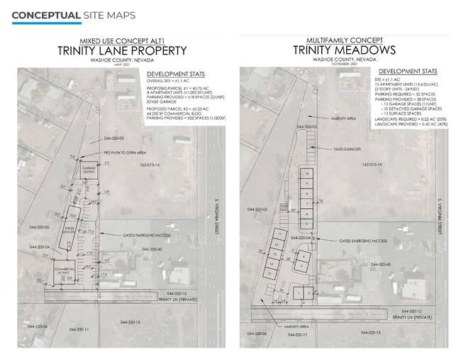
ROS 6441 PAR A
044-320-58
Washoe
Residentialacreage
Nevada
0
1.10 AC
2026
South Meadows
001011
NEARBY LISTINGS FOR SALE OR LEASE
DEMOGRAPHICS near 205 Trinity Ln
1 mile
3 mile
5 mile
2024 Total Population
5,357
61,304
97,088
2029 Population
5,596
65,353
102,689
Pop Growth 2024-2029
+ 4.46%
+ 6.60%
+ 5.77%
Average Age
46
42
42
2024 Total Households
2,433
24,844
39,613
HH Growth 2024-2029
+ 4.48%
+ 6.77%
+ 5.90%
Median Household Inc
$115,699
$112,635
$97,989
Avg Household Size
2.20
2.40
2.40
2024 Avg HH Vehicles
2.00
2.00
2.00
Median Home Value
$704,345
$621,015
$585,679
Median Year Built
2002
2004
1997
Nearby Places
Map Layers
Map Styles
 Street
 Aerial
Transit
 Traffic
 Biking
Places
Listings with unknown addresses are not visible on the map
- Restaurants
- Banks
- Shops
- Fitness
- Groceries
PUBLIC TRANSPORTATION
AIRPORT
Reno/Tahoe International
Drive
Walk
Distance
Reno/Tahoe International
29 min
10.5 mi
Freight Ports
Port of Stockton
Drive
Walk
Distance
Port of Stockton
221 min
189.7 mi
SALE & LEASE HISTORY
LISTING DATE
SALE/LEASE

Oct 31, 2024
For Sale
Nearby Properties
Address
Land Use
TOTAL SIZE
Lot Size
Zoning
Address
Land Use
TOTAL SIZE
Lot Size
Zoning
1,051,043 SF
78.81 AC
PD
Address
Land Use
TOTAL SIZE
Lot Size
Zoning
271,546 SF
20.62 AC
PD
Address
Land Use
TOTAL SIZE
Lot Size
Zoning
476,624 SF
19.33 AC
PD
Address
Land Use
TOTAL SIZE
Lot Size
Zoning
451,635 SF
15 AC
PD
Address
Land Use
TOTAL SIZE
Lot Size
Zoning
418,177 SF
16.59 AC
MS
Address
Land Use
TOTAL SIZE
Lot Size
Zoning
421,744 SF
12.07 AC
MS
Address
Land Use
TOTAL SIZE
Lot Size
Zoning
430,526 SF
14.79 AC
MS
Address
Land Use
TOTAL SIZE
Lot Size
Zoning
191,762 SF
51.49 AC
LDS
Address
Land Use
TOTAL SIZE
Lot Size
Zoning
410,834 SF
11.58 AC
MS
Address
Land Use
TOTAL SIZE
Lot Size
Zoning
308,769 SF
17.53 AC
PD
Address
Land Use
TOTAL SIZE
Lot Size
Zoning
389,745 SF
15.17 AC
MS
Address
Land Use
TOTAL SIZE
Lot Size
Zoning
327,867 SF
12.11 AC
PD
Address
Land Use
TOTAL SIZE
Lot Size
Zoning
181,150 SF
27.71 AC
PD
Address
Land Use
TOTAL SIZE
Lot Size
Zoning
379,347 SF
18.42 AC
MS
Address
Land Use
TOTAL SIZE
Lot Size
Zoning
476,624 SF
19.50 AC
PD
Address
Land Use
TOTAL SIZE
Lot Size
Zoning
257,652 SF
23.36 AC
MS
Address
Land Use
TOTAL SIZE
Lot Size
Zoning
310,004 SF
11.77 AC
PD
Address
Land Use
TOTAL SIZE
Lot Size
Zoning
283,103 SF
10.02 AC
PD
Address
Land Use
TOTAL SIZE
Lot Size
Zoning
276,780 SF
60.26 AC
PD
Address
Land Use
TOTAL SIZE
Lot Size
Zoning
296,169 SF
15.33 AC
MS
Address
Land Use
TOTAL SIZE
Lot Size
Zoning
335,490 SF
19.54 AC
PD
Address
Land Use
TOTAL SIZE
Lot Size
Zoning
392,820 SF
24.82 AC
MS
Address
Land Use
TOTAL SIZE
Lot Size
Zoning
342,019 SF
23.32 AC
MF14
Address
Land Use
TOTAL SIZE
Lot Size
Zoning
365,634 SF
19.70 AC
MF21
Address
Land Use
TOTAL SIZE
Lot Size
Zoning
151,254 SF
48.11 AC
MDS
Address
Land Use
TOTAL SIZE
Lot Size
Zoning
389,667 SF
19.52 AC
MS
Address
Land Use
TOTAL SIZE
Lot Size
Zoning
240,094 SF
8.16 AC
MS
Address
Land Use
TOTAL SIZE
Lot Size
Zoning
209,359 SF
10.98 AC
PD
Address
Land Use
TOTAL SIZE
Lot Size
Zoning
601,250 SF
27.39 AC
MS
Address
Land Use
TOTAL SIZE
Lot Size
Zoning
212,660 SF
5.21 AC
MS
The World's #1 Commercial Real Estate Marketplace
Connect with us
© 2026 CoStar Group
The information above has been obtained from sources believed reliable. While we do not doubt its accuracy we have not verified it and make no guarantee, warranty or representation about it. It is your responsibility to independently confirm its accuracy and completeness. Any projections, opinions, assumptions, or estimates used are for example only and do not represent the current or future performance of the property. The value of this transaction to you depends on tax and other factors which should be evaluated by your tax, financial, and legal advisors. You and your advisors should conduct a careful, independent investigation of the property to determine to your satisfaction the suitability of the property for your needs.