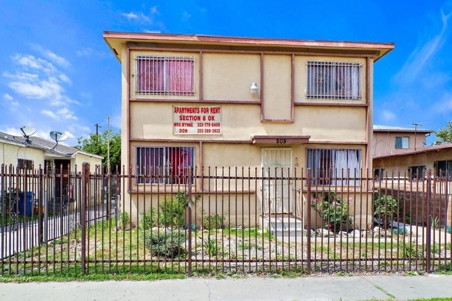
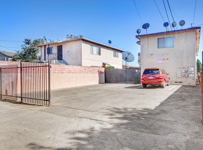
Property Record
205 W 89Th St, Los Angeles, CA 90003

NEARBY LISTINGS FOR SALE OR LEASE
Property Detail
205 W 89Th St
Los Angeles-Long Beach-Glendale, CA
672
6040-026-003
TRACT # 672 LOT 79
Quadruplex
Los Angeles
X
California
06037C1785G
79
2024
0.12 AC
2025
Canndu/Avalon Gardens
240200
Los Angeles
3,591 SF
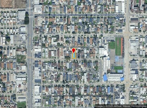
DEMOGRAPHICS near 205 W 89Th St
1 Mile
3 Mile
5 Mile
2024 Total Population
63,168
422,783
1,049,769
2029 Population
60,892
406,428
1,006,306
Pop Growth 2024-2029
(3.60%)
(3.87%)
(4.14%)
Average Age
34
35
36
2024 Total Households
15,964
111,547
290,078
HH Growth 2024-2029
(3.90%)
(4.13%)
(4.32%)
Median Household Inc
$43,880
$51,861
$54,764
Avg Household Size
3.70
3.60
3.40
2024 Avg HH Vehicles
2.00
2.00
2.00
Median Home Value
$479,564
$580,561
$619,640
Median Year Built
1955
1950
1954
Nearby Places
Map Layers
Map Styles
 Street
 Aerial
- Restaurants
- Banks
- Shops
- Fitness
- Groceries
PUBLIC TRANSPORTATION
COMMUTER RAIL
Los Angeles (Coast Starlight - Amtrak, Pacific Surfliner - Amtrak, Southwest Chief - Amtrak, Texas Eagle - Amtrak)
DRIVE
WALK
Distance
Los Angeles (Coast Starlight - Amtrak, Pacific Surfliner - Amtrak, Southwest Chief - Amtrak, Texas Eagle - Amtrak)
13 min
9.1 mi
Union Station (91 Line - Southern California Regional Rail Authority (Metrolink), Antelope Valley Line - Southern California Regional Rail Authority (Metrolink), Orange County Line - Southern California Regional Rail Authority (Metrolink), Riverside Line - Southern California Regional Rail Authority (Metrolink), San Bernardino Line - Southern California Regional Rail Authority (Metrolink), Ventura County Line - Southern California Regional Rail Authority (Metrolink))
DRIVE
WALK
Distance
Union Station (91 Line - Southern California Regional Rail Authority (Metrolink), Antelope Valley Line - Southern California Regional Rail Authority (Metrolink), Orange County Line - Southern California Regional Rail Authority (Metrolink), Riverside Line - Southern California Regional Rail Authority (Metrolink), San Bernardino Line - Southern California Regional Rail Authority (Metrolink), Ventura County Line - Southern California Regional Rail Authority (Metrolink))
15 min
9.3 mi
AIRPORT
Los Angeles International
DRIVE
WALK
Distance
Los Angeles International
16 min
8.4 mi
Long Beach (Daugherty Field)
DRIVE
WALK
Distance
Long Beach (Daugherty Field)
23 min
16.7 mi
Bob Hope
DRIVE
WALK
Distance
Bob Hope
33 min
24.3 mi
Freight Ports
Port of Long Beach
DRIVE
WALK
Distance
Port of Long Beach
26 min
18.5 mi
SALE & LEASE HISTORY
LISTING DATE
SALE/LEASE

Jun 15, 2017
For Sale
Aug 15, 2019
For Sale
Nearby Properties
Address
Land Use
TOTAL SIZE
Lot Size
Zoning
Address
Land Use
TOTAL SIZE
Lot Size
Zoning
2,531,696 SF
79.60 AC
INCR*
Address
Land Use
TOTAL SIZE
Lot Size
Zoning
108,598 SF
15.93 AC
LCC3*
Address
Land Use
TOTAL SIZE
Lot Size
Zoning
63,922 SF
1.82 AC
LCA16000*
Address
Land Use
TOTAL SIZE
Lot Size
Zoning
127,484 SF
7.33 AC
LAM2
Address
Land Use
TOTAL SIZE
Lot Size
Zoning
81,735 SF
4.10 AC
LAR4
Address
Land Use
TOTAL SIZE
Lot Size
Zoning
104,291 SF
7.35 AC
LAR3
Address
Land Use
TOTAL SIZE
Lot Size
Zoning
134,514 SF
1.94 AC
LCM2*
Address
Land Use
TOTAL SIZE
Lot Size
Zoning
103,656 SF
6.98 AC
LCM1
Address
Land Use
TOTAL SIZE
Lot Size
Zoning
293,886 SF
4.98 AC
SGM3
Address
Land Use
TOTAL SIZE
Lot Size
Zoning
93,597 SF
0.32 AC
LCC2
Address
Land Use
TOTAL SIZE
Lot Size
Zoning
402,118 SF
9.39 AC
LAC2
Address
Land Use
TOTAL SIZE
Lot Size
Zoning
111,213 SF
12.04 AC
LAR4
Address
Land Use
TOTAL SIZE
Lot Size
Zoning
188,030 SF
3.09 AC
LAR5
Address
Land Use
TOTAL SIZE
Lot Size
Zoning
101,562 SF
7.53 AC
LAR3
Address
Land Use
TOTAL SIZE
Lot Size
Zoning
52,331 SF
4.17 AC
SG
Address
Land Use
TOTAL SIZE
Lot Size
Zoning
102,260 SF
16.84 AC
LAR4
Address
Land Use
TOTAL SIZE
Lot Size
Zoning
90,887 SF
0.94 AC
LCR320U*
Address
Land Use
TOTAL SIZE
Lot Size
Zoning
152,151 SF
3.59 AC
LCM2*
Address
Land Use
TOTAL SIZE
Lot Size
Zoning
589,061 SF
19.32 AC
SGM3
Address
Land Use
TOTAL SIZE
Lot Size
Zoning
189,808 SF
4.07 AC
LAM2
Address
Land Use
TOTAL SIZE
Lot Size
Zoning
184,500 SF
3 AC
COML*
Address
Land Use
TOTAL SIZE
Lot Size
Zoning
108,496 SF
9.82 AC
LAM2
Address
Land Use
TOTAL SIZE
Lot Size
Zoning
113,733 SF
1.59 AC
LAM2
Address
Land Use
TOTAL SIZE
Lot Size
Zoning
38,567 SF
1.11 AC
LAR3
Address
Land Use
TOTAL SIZE
Lot Size
Zoning
40,065 SF
1.24 AC
LAC2
Address
Land Use
TOTAL SIZE
Lot Size
Zoning
78,505 SF
3.21 AC
HPM2*
Address
Land Use
TOTAL SIZE
Lot Size
Zoning
93,319 SF
1.70 AC
LAM2
Address
Land Use
TOTAL SIZE
Lot Size
Zoning
171,971 SF
5.21 AC
LCM2*
Address
Land Use
TOTAL SIZE
Lot Size
Zoning
44,769 SF
0.84 AC
LAC2
Address
Land Use
TOTAL SIZE
Lot Size
Zoning
75,444 SF
2.98 AC
HPM2YY
The World's #1 Commercial Real Estate Marketplace
Connect with us
© 2025 CoStar Group
The information above has been obtained from sources believed reliable. While we do not doubt its accuracy we have not verified it and make no guarantee, warranty or representation about it. It is your responsibility to independently confirm its accuracy and completeness. Any projections, opinions, assumptions, or estimates used are for example only and do not represent the current or future performance of the property. The value of this transaction to you depends on tax and other factors which should be evaluated by your tax, financial, and legal advisors. You and your advisors should conduct a careful, independent investigation of the property to determine to your satisfaction the suitability of the property for your needs.