Property Record
205 W Madison St, Starke, FL 32091
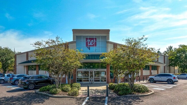

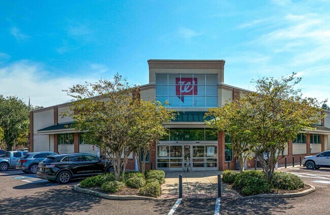
This Property Is For Sale
Property Detail
205 W Madison St
03151-0-00000
28 6S 22 COM INT SE R/W HWY 301 & S R/W CALL ST. S73*2826E 249.08, S17*4146W 62.75, S73*1012E 39.61, S17*4146W 2, THENCE S73*1012E 41.84, S17*0751W 43.65, S73*2204E 20.41, S16*2655W 105.55, THENCE N73*3729W 309.89, THENCE N30*4648W 47.60, N13*5943E 7
Storemultistory
Bradford
B and X Area of moderate flood hazard, usually the area between the limits of the 100-year and 500-year floods.
Florida
2025
1.54 AC
2025
Florida Central North Area
000100
Other Market Areas
15,287 SF
NEARBY LISTINGS FOR SALE OR LEASE
-
-
-
-
-
No Photo
-
View all Starke listings for sale on LoopNet.com
DEMOGRAPHICS near 205 W Madison St
1 mile
3 mile
5 mile
2025 Total Population
4,584
10,158
13,432
2030 Population
4,894
10,842
14,309
Pop Growth 2025-2030
+ 6.76%
+ 6.73%
+ 6.53%
Average Age
41
41
41
2025 Total Households
1,765
3,862
5,072
HH Growth 2025-2030
+ 6.12%
+ 6.14%
+ 6.03%
Median Household Inc
$46,666
$49,582
$53,333
Avg Household Size
2.50
2.50
2.50
2025 Avg HH Vehicles
2.00
2.00
2.00
Median Home Value
$215,068
$195,815
$195,201
Median Year Built
1978
1982
1983
Nearby Places
Map Layers
Map Styles
 Street
 Aerial
Transit
 Traffic
 Biking
Places
Listings with unknown addresses are not visible on the map
- Restaurants
- Banks
- Shops
- Fitness
- Groceries
PUBLIC TRANSPORTATION
AIRPORT
Gainesville Regional
Drive
Walk
Distance
Gainesville Regional
37 min
23.7 mi
Freight Ports
Jacksonville Port
Drive
Walk
Distance
Jacksonville Port
66 min
49.0 mi
Nearby Properties
Address
Land Use
TOTAL SIZE
Lot Size
Zoning
Address
Land Use
TOTAL SIZE
Lot Size
Zoning
168,336 SF
23.97 AC
Address
Land Use
TOTAL SIZE
Lot Size
Zoning
96,617 SF
11 AC
Address
Land Use
TOTAL SIZE
Lot Size
Zoning
63,568 SF
8.54 AC
Address
Land Use
TOTAL SIZE
Lot Size
Zoning
117,119 SF
30.15 AC
Address
Land Use
TOTAL SIZE
Lot Size
Zoning
24,370 SF
1.27 AC
Address
Land Use
TOTAL SIZE
Lot Size
Zoning
64,054 SF
4.07 AC
Address
Land Use
TOTAL SIZE
Lot Size
Zoning
74,461 SF
7.92 AC
Address
Land Use
TOTAL SIZE
Lot Size
Zoning
119,949 SF
5.50 AC
Address
Land Use
TOTAL SIZE
Lot Size
Zoning
51,918 SF
7.97 AC
Address
Land Use
TOTAL SIZE
Lot Size
Zoning
69,258 SF
10 AC
Address
Land Use
TOTAL SIZE
Lot Size
Zoning
35,032 SF
8.75 AC
Address
Land Use
TOTAL SIZE
Lot Size
Zoning
30,963 SF
7.47 AC
Address
Land Use
TOTAL SIZE
Lot Size
Zoning
111,635 SF
44.63 AC
Address
Land Use
TOTAL SIZE
Lot Size
Zoning
84,782 SF
5.89 AC
Address
Land Use
TOTAL SIZE
Lot Size
Zoning
42,534 SF
1.86 AC
Address
Land Use
TOTAL SIZE
Lot Size
Zoning
47,283 SF
5.70 AC
Address
Land Use
TOTAL SIZE
Lot Size
Zoning
38,431 SF
13.76 AC
Address
Land Use
TOTAL SIZE
Lot Size
Zoning
104,030 SF
24.65 AC
Address
Land Use
TOTAL SIZE
Lot Size
Zoning
65,461 SF
8 AC
Address
Land Use
TOTAL SIZE
Lot Size
Zoning
23,225 SF
4.81 AC
Address
Land Use
TOTAL SIZE
Lot Size
Zoning
7,572 SF
1.32 AC
Address
Land Use
TOTAL SIZE
Lot Size
Zoning
29,120 SF
3.26 AC
Address
Land Use
TOTAL SIZE
Lot Size
Zoning
56,944 SF
6.55 AC
Address
Land Use
TOTAL SIZE
Lot Size
Zoning
63.28 AC
Address
Land Use
TOTAL SIZE
Lot Size
Zoning
16,274 SF
1.51 AC
Address
Land Use
TOTAL SIZE
Lot Size
Zoning
35,950 SF
2.76 AC
Address
Land Use
TOTAL SIZE
Lot Size
Zoning
22,052 SF
2.67 AC
Address
Land Use
TOTAL SIZE
Lot Size
Zoning
7,490 SF
18.84 AC
Address
Land Use
TOTAL SIZE
Lot Size
Zoning
14,806 SF
6.80 AC
The World's #1 Commercial Real Estate Marketplace
Connect with us
© 2026 CoStar Group
The information above has been obtained from sources believed reliable. While we do not doubt its accuracy we have not verified it and make no guarantee, warranty or representation about it. It is your responsibility to independently confirm its accuracy and completeness. Any projections, opinions, assumptions, or estimates used are for example only and do not represent the current or future performance of the property. The value of this transaction to you depends on tax and other factors which should be evaluated by your tax, financial, and legal advisors. You and your advisors should conduct a careful, independent investigation of the property to determine to your satisfaction the suitability of the property for your needs.