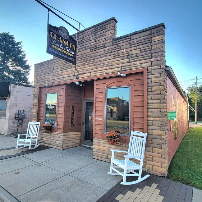
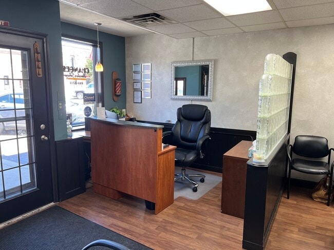
Property Record
203 W Main St, Durand, MI 48429
NEARBY LISTINGS FOR SALE OR LEASE
Property Detail
203 W Main St
Owosso, MI
City Of Durand
020-12-006-003-00
THE EAST 17 FT OF LOT 2, EXCEPT THE N 7 FT THEREOF, THE W 3 FT OF LOT 1, EXCEPT THE N 7 FT THEREOF, AND THE E 5 FT OF THE W 8
Storebuilding
Shiawassee
X
Michigan
26155C0300C
2,1
2024
0.08 AC
2025
Midland/Flint
031900
Other Market Areas
2,081 SF
DEMOGRAPHICS near 203 W Main St
1 Mile
3 Mile
5 Mile
2024 Total Population
3,944
6,926
12,785
2029 Population
3,982
6,969
12,767
Pop Growth 2024-2029
+ 0.96%
+ 0.62%
(0.14%)
Average Age
42
43
44
2024 Total Households
1,697
2,988
5,349
HH Growth 2024-2029
+ 1.06%
+ 0.80%
+ 0.04%
Median Household Inc
$50,075
$52,307
$56,078
Avg Household Size
2.20
2.20
2.30
2024 Avg HH Vehicles
2.00
2.00
2.00
Median Home Value
$117,377
$130,595
$150,366
Median Year Built
1951
1964
1968
Nearby Places
Map Layers
Map Styles
 Street
 Aerial
- Restaurants
- Banks
- Shops
- Fitness
- Groceries
PUBLIC TRANSPORTATION
COMMUTER RAIL
DRIVE
WALK
Distance
2 min
15 min
0.8 mi
AIRPORT
Bishop International
DRIVE
WALK
Distance
Bishop International
31 min
18.5 mi
Capital Region International
DRIVE
WALK
Distance
Capital Region International
48 min
40.4 mi
SALE & LEASE HISTORY
LISTING DATE
SALE/LEASE

Oct 19, 2023
For Sale
May 15, 2024
For Sale
Nearby Properties
Address
Land Use
TOTAL SIZE
Lot Size
Zoning
Address
Land Use
TOTAL SIZE
Lot Size
Zoning
46,164 SF
5.51 AC
R-M
Address
Land Use
TOTAL SIZE
Lot Size
Zoning
12,890 SF
0.54 AC
R-1
Address
Land Use
TOTAL SIZE
Lot Size
Zoning
118,988 SF
22.79 AC
I-2
Address
Land Use
TOTAL SIZE
Lot Size
Zoning
87,234 SF
8.33 AC
R-M
Address
Land Use
TOTAL SIZE
Lot Size
Zoning
32,792 SF
11.52 AC
C-2
Address
Land Use
TOTAL SIZE
Lot Size
Zoning
66 AC
Address
Land Use
TOTAL SIZE
Lot Size
Zoning
67.70 AC
Address
Land Use
TOTAL SIZE
Lot Size
Zoning
18,780 SF
2.52 AC
R-M
Address
Land Use
TOTAL SIZE
Lot Size
Zoning
19,800 SF
2.66 AC
R-M
Address
Land Use
TOTAL SIZE
Lot Size
Zoning
7.01 AC
Address
Land Use
TOTAL SIZE
Lot Size
Zoning
8.10 AC
Address
Land Use
TOTAL SIZE
Lot Size
Zoning
27,888 SF
2.59 AC
C-1
Address
Land Use
TOTAL SIZE
Lot Size
Zoning
3.70 AC
Address
Land Use
TOTAL SIZE
Lot Size
Zoning
15,000 SF
3.03 AC
I-2
Address
Land Use
TOTAL SIZE
Lot Size
Zoning
179.46 AC
Address
Land Use
TOTAL SIZE
Lot Size
Zoning
11,100 SF
1.57 AC
C-2
Address
Land Use
TOTAL SIZE
Lot Size
Zoning
11,703 SF
1.99 AC
C-2
Address
Land Use
TOTAL SIZE
Lot Size
Zoning
3,168 SF
1.09 AC
C-2
Address
Land Use
TOTAL SIZE
Lot Size
Zoning
5,600 SF
0.69 AC
R-1
Address
Land Use
TOTAL SIZE
Lot Size
Zoning
Address
Land Use
TOTAL SIZE
Lot Size
Zoning
16.48 AC
Address
Land Use
TOTAL SIZE
Lot Size
Zoning
Address
Land Use
TOTAL SIZE
Lot Size
Zoning
Address
Land Use
TOTAL SIZE
Lot Size
Zoning
9,301 SF
2.29 AC
R-M
Address
Land Use
TOTAL SIZE
Lot Size
Zoning
20,982 SF
2.88 AC
R-M
Address
Land Use
TOTAL SIZE
Lot Size
Zoning
1,560 SF
0.96 AC
C-2
Address
Land Use
TOTAL SIZE
Lot Size
Zoning
146.30 AC
Address
Land Use
TOTAL SIZE
Lot Size
Zoning
Address
Land Use
TOTAL SIZE
Lot Size
Zoning
19,200 SF
1.44 AC
R-M
Address
Land Use
TOTAL SIZE
Lot Size
Zoning
71.60 AC
The World's #1 Commercial Real Estate Marketplace
Connect with us
© 2026 CoStar Group
The information above has been obtained from sources believed reliable. While we do not doubt its accuracy we have not verified it and make no guarantee, warranty or representation about it. It is your responsibility to independently confirm its accuracy and completeness. Any projections, opinions, assumptions, or estimates used are for example only and do not represent the current or future performance of the property. The value of this transaction to you depends on tax and other factors which should be evaluated by your tax, financial, and legal advisors. You and your advisors should conduct a careful, independent investigation of the property to determine to your satisfaction the suitability of the property for your needs.