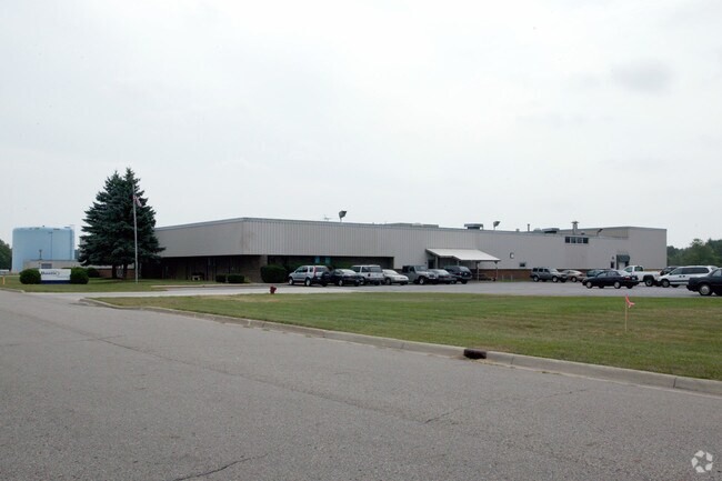
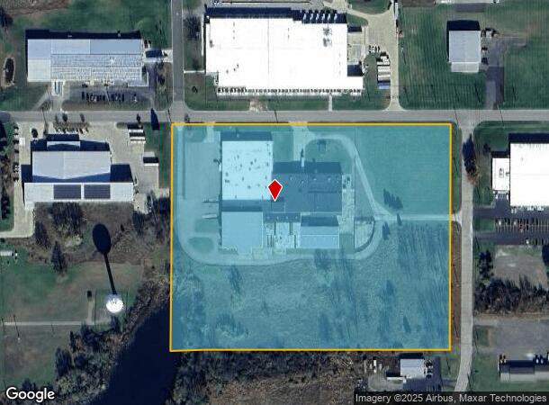
Property Record
205 W Oliver Dr, Marshall, MI 49068


This Property Is For Sale
NEARBY LISTINGS FOR SALE OR LEASE
Property Detail
205 W Oliver Dr
53-003-001-00
MARSHALL CITY, PART OF SEC 1-3-6 BEG 1125 FT W & 40 FT S OF N 1/4 POST S 726 FT W 900 FT, N 726 FT, E 900 FT TO POB
Manufacturinglight
Calhoun
X
Michigan
26025C0380C
15 AC
2024
Eastern Calhoun County
2025
West Michigan
004000
Battle Creek, MI
103,608 SF
DEMOGRAPHICS near 205 W Oliver Dr
1 mile
3 mile
5 mile
2024 Total Population
326
9,185
11,959
2029 Population
325
9,081
11,810
Pop Growth 2024-2029
(0.31%)
(1.13%)
(1.25%)
Average Age
41
42
43
2024 Total Households
140
4,009
5,114
HH Growth 2024-2029
0.00%
(1.05%)
(1.17%)
Median Household Inc
$68,124
$68,553
$71,345
Avg Household Size
2.30
2.20
2.30
2024 Avg HH Vehicles
2.00
2.00
2.00
Median Home Value
$168,867
$176,437
$186,053
Median Year Built
1966
1956
1959
Nearby Places
Map Layers
Map Styles
 Street
 Aerial
Transit
 Traffic
 Biking
Places
Listings with unknown addresses are not visible on the map
- Restaurants
- Banks
- Shops
- Fitness
- Groceries
Nearby Properties
Address
Land Use
TOTAL SIZE
Lot Size
Zoning
Address
Land Use
TOTAL SIZE
Lot Size
Zoning
160,000 SF
68.23 AC
Address
Land Use
TOTAL SIZE
Lot Size
Zoning
110,286 SF
9.22 AC
I-1
Address
Land Use
TOTAL SIZE
Lot Size
Zoning
161,646 SF
435.70 AC
Address
Land Use
TOTAL SIZE
Lot Size
Zoning
251,089 SF
15 AC
I-1
Address
Land Use
TOTAL SIZE
Lot Size
Zoning
89,699 SF
7.93 AC
B-4
Address
Land Use
TOTAL SIZE
Lot Size
Zoning
245,908 SF
11.46 AC
I-1
Address
Land Use
TOTAL SIZE
Lot Size
Zoning
50,700 SF
Address
Land Use
TOTAL SIZE
Lot Size
Zoning
80,288 SF
4.22 AC
MFRD
Address
Land Use
TOTAL SIZE
Lot Size
Zoning
53,239 SF
2.95 AC
PUD
Address
Land Use
TOTAL SIZE
Lot Size
Zoning
241.30 AC
LI
Address
Land Use
TOTAL SIZE
Lot Size
Zoning
1,302 SF
11.75 AC
Address
Land Use
TOTAL SIZE
Lot Size
Zoning
56,000 SF
9.59 AC
I-1
Address
Land Use
TOTAL SIZE
Lot Size
Zoning
10,085 SF
3.88 AC
B4-GEN (IA
Address
Land Use
TOTAL SIZE
Lot Size
Zoning
57,700 SF
8.31 AC
I-1
Address
Land Use
TOTAL SIZE
Lot Size
Zoning
111,882 SF
59.51 AC
I-2
Address
Land Use
TOTAL SIZE
Lot Size
Zoning
36,660 SF
6.73 AC
I-1
Address
Land Use
TOTAL SIZE
Lot Size
Zoning
9,041 SF
30.30 AC
FS FREEWAY
Address
Land Use
TOTAL SIZE
Lot Size
Zoning
41,934 SF
11.21 AC
I-1
Address
Land Use
TOTAL SIZE
Lot Size
Zoning
71,725 SF
4.74 AC
I-1
Address
Land Use
TOTAL SIZE
Lot Size
Zoning
1,226 SF
565 AC
RESIDEN
Address
Land Use
TOTAL SIZE
Lot Size
Zoning
28,215 SF
4.20 AC
AGRICU
Address
Land Use
TOTAL SIZE
Lot Size
Zoning
59,916 SF
5.58 AC
I-1
Address
Land Use
TOTAL SIZE
Lot Size
Zoning
241.30 AC
LI
Address
Land Use
TOTAL SIZE
Lot Size
Zoning
54,612 SF
3.70 AC
MFRD
Address
Land Use
TOTAL SIZE
Lot Size
Zoning
74,904 SF
4.91 AC
MFRD
Address
Land Use
TOTAL SIZE
Lot Size
Zoning
8.65 AC
Address
Land Use
TOTAL SIZE
Lot Size
Zoning
45,659 SF
3.54 AC
B-4
Address
Land Use
TOTAL SIZE
Lot Size
Zoning
137,522 SF
14.15 AC
I-2
Address
Land Use
TOTAL SIZE
Lot Size
Zoning
33,400 SF
3.08 AC
B-4 GEN
The World's #1 Commercial Real Estate Marketplace
Connect with us
© 2026 CoStar Group
The information above has been obtained from sources believed reliable. While we do not doubt its accuracy we have not verified it and make no guarantee, warranty or representation about it. It is your responsibility to independently confirm its accuracy and completeness. Any projections, opinions, assumptions, or estimates used are for example only and do not represent the current or future performance of the property. The value of this transaction to you depends on tax and other factors which should be evaluated by your tax, financial, and legal advisors. You and your advisors should conduct a careful, independent investigation of the property to determine to your satisfaction the suitability of the property for your needs.