Property Record
205 Wb Mclean Dr, Cape Carteret, NC 28584

NEARBY LISTINGS FOR SALE OR LEASE
-
-
View all Cape Carteret listings for sale on LoopNet.com
Property Detail
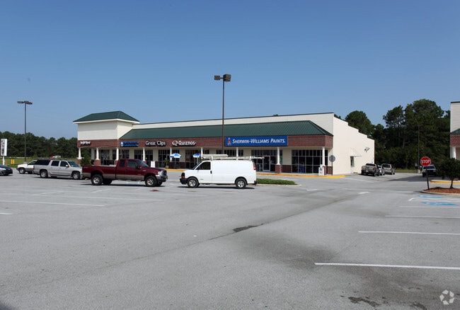
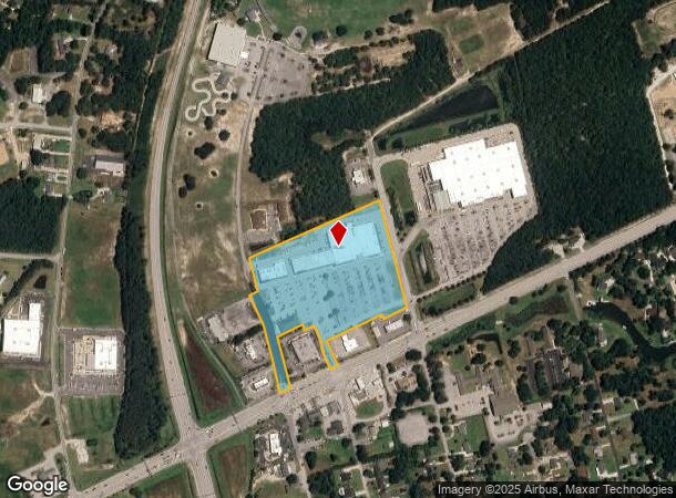
205 Wb Mclean Dr
5384.05.08.9241000
Carteret Crossing Shopping Center
Commercialnec
TRACT 3 CARTERET CROSSING SHOPPING CENTER
X
Carteret
3720538400K
North Carolina
2025
11.83 AC
2025
Coastal Carolina
970806
Other Market Areas
60,867 SF
Morehead City, NC
DEMOGRAPHICS near 205 Wb Mclean Dr
1 Mile
3 Mile
5 Mile
2024 Total Population
2,012
9,862
19,964
2029 Population
2,135
10,532
21,454
Pop Growth 2024-2029
+ 6.11%
+ 6.79%
+ 7.46%
Average Age
47
47
46
2024 Total Households
864
4,302
8,593
HH Growth 2024-2029
+ 5.90%
+ 6.81%
+ 7.59%
Median Household Inc
$66,627
$74,435
$72,044
Avg Household Size
2.30
2.30
2.30
2024 Avg HH Vehicles
2.00
2.00
2.00
Median Home Value
$312,977
$339,481
$325,679
Median Year Built
1991
1992
1994
Nearby Places
Map Layers
Map Styles
 Street
 Aerial
- Restaurants
- Banks
- Shops
- Fitness
- Groceries
PUBLIC TRANSPORTATION
AIRPORT
Coastal Carolina Regional
DRIVE
WALK
Distance
Coastal Carolina Regional
57 min
35.8 mi
Freight Ports
Port of Morehead City
DRIVE
WALK
Distance
Port of Morehead City
33 min
21.5 mi
Nearby Properties
Address
Land Use
TOTAL SIZE
Lot Size
Zoning
Address
Land Use
TOTAL SIZE
Lot Size
Zoning
852.63 AC
Address
Land Use
TOTAL SIZE
Lot Size
Zoning
5,952 SF
18.03 AC
Address
Land Use
TOTAL SIZE
Lot Size
Zoning
184,862 SF
11.40 AC
Address
Land Use
TOTAL SIZE
Lot Size
Zoning
10,071 SF
9.13 AC
Address
Land Use
TOTAL SIZE
Lot Size
Zoning
82,345 SF
21.69 AC
Address
Land Use
TOTAL SIZE
Lot Size
Zoning
3,600 SF
30.42 AC
Address
Land Use
TOTAL SIZE
Lot Size
Zoning
6,000 SF
6.80 AC
Address
Land Use
TOTAL SIZE
Lot Size
Zoning
Address
Land Use
TOTAL SIZE
Lot Size
Zoning
44,906 SF
4.27 AC
Address
Land Use
TOTAL SIZE
Lot Size
Zoning
41,517 SF
30.20 AC
Address
Land Use
TOTAL SIZE
Lot Size
Zoning
8,484 SF
1.35 AC
Address
Land Use
TOTAL SIZE
Lot Size
Zoning
16,048 SF
1.62 AC
Address
Land Use
TOTAL SIZE
Lot Size
Zoning
35,101 SF
3.33 AC
Address
Land Use
TOTAL SIZE
Lot Size
Zoning
Address
Land Use
TOTAL SIZE
Lot Size
Zoning
27,666 SF
1.37 AC
Address
Land Use
TOTAL SIZE
Lot Size
Zoning
Address
Land Use
TOTAL SIZE
Lot Size
Zoning
37,992 SF
4.06 AC
Address
Land Use
TOTAL SIZE
Lot Size
Zoning
Address
Land Use
TOTAL SIZE
Lot Size
Zoning
39,015 SF
4.45 AC
Address
Land Use
TOTAL SIZE
Lot Size
Zoning
110,331 SF
4.14 AC
Address
Land Use
TOTAL SIZE
Lot Size
Zoning
11,900 SF
1.46 AC
Address
Land Use
TOTAL SIZE
Lot Size
Zoning
30,908 SF
1.03 AC
Address
Land Use
TOTAL SIZE
Lot Size
Zoning
15,072 SF
5.17 AC
Address
Land Use
TOTAL SIZE
Lot Size
Zoning
34,412 SF
3.88 AC
Address
Land Use
TOTAL SIZE
Lot Size
Zoning
1,008 SF
4.41 AC
Address
Land Use
TOTAL SIZE
Lot Size
Zoning
36,989 SF
6.81 AC
Address
Land Use
TOTAL SIZE
Lot Size
Zoning
7,642 SF
3.16 AC
Address
Land Use
TOTAL SIZE
Lot Size
Zoning
Address
Land Use
TOTAL SIZE
Lot Size
Zoning
19,216 SF
6.36 AC
The World's #1 Commercial Real Estate Marketplace
Connect with us
© 2026 CoStar Group
The information above has been obtained from sources believed reliable. While we do not doubt its accuracy we have not verified it and make no guarantee, warranty or representation about it. It is your responsibility to independently confirm its accuracy and completeness. Any projections, opinions, assumptions, or estimates used are for example only and do not represent the current or future performance of the property. The value of this transaction to you depends on tax and other factors which should be evaluated by your tax, financial, and legal advisors. You and your advisors should conduct a careful, independent investigation of the property to determine to your satisfaction the suitability of the property for your needs.