Property Record
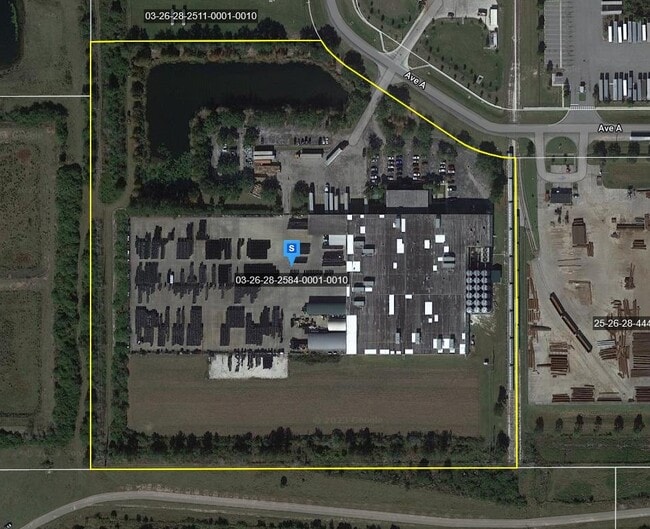
2050 Avenue A, Kissimmee, FL 34758

NEARBY LISTINGS FOR SALE OR LEASE
Property Detail
2050 Avenue A
Orlando-Kissimmee-Sanford, FL
Avenue `A` Replat
03-26-28-2584-0001-0010
AVENUE A REPLAT PB 12 PG 96 LOT 1 10/26/28
Lightindustrial
Osceola
A
Florida
12097C0230G
1
2024
24.32 AC
2025
Osceola County
041004
Orlando
121,488 SF
DEMOGRAPHICS near 2050 Avenue A
1 Mile
3 Mile
5 Mile
2024 Total Population
2,880
24,064
80,304
2029 Population
3,308
28,872
97,261
Pop Growth 2024-2029
+ 14.86%
+ 19.98%
+ 21.12%
Average Age
37
38
38
2024 Total Households
824
7,558
25,368
HH Growth 2024-2029
+ 14.68%
+ 20.06%
+ 21.12%
Median Household Inc
$68,508
$61,150
$61,682
Avg Household Size
3.30
3.10
3.10
2024 Avg HH Vehicles
3.00
2.00
2.00
Median Home Value
$250,897
$260,089
$267,917
Median Year Built
2005
2005
2004
Nearby Places
Map Layers
Map Styles
 Street
 Aerial
- Restaurants
- Banks
- Shops
- Fitness
- Groceries
PUBLIC TRANSPORTATION
COMMUTER RAIL
Poinciana (SunRail - Florida Department of Transportation)
DRIVE
WALK
Distance
Poinciana (SunRail - Florida Department of Transportation)
4 min
1.5 mi
Kissimmee Amtrak Station (Silver Meteor - Amtrak, Silver Star - Amtrak, SunRail - Amtrak)
DRIVE
WALK
Distance
Kissimmee Amtrak Station (Silver Meteor - Amtrak, Silver Star - Amtrak, SunRail - Amtrak)
15 min
7.8 mi
AIRPORT
Orlando International
DRIVE
WALK
Distance
Orlando International
40 min
25.4 mi
Freight Ports
Port Canaveral
DRIVE
WALK
Distance
Port Canaveral
87 min
67.1 mi
Nearby Properties
Address
Land Use
TOTAL SIZE
Lot Size
Zoning
Address
Land Use
TOTAL SIZE
Lot Size
Zoning
1,348,847 SF
149.20 AC
OPD
Address
Land Use
TOTAL SIZE
Lot Size
Zoning
280,364 SF
18.38 AC
OPD
Address
Land Use
TOTAL SIZE
Lot Size
Zoning
253,073 SF
20.26 AC
OPD
Address
Land Use
TOTAL SIZE
Lot Size
Zoning
346,648 SF
69.44 AC
OPD
Address
Land Use
TOTAL SIZE
Lot Size
Zoning
218,438 SF
58.99 AC
OAC
Address
Land Use
TOTAL SIZE
Lot Size
Zoning
98,237 SF
6.64 AC
OPD
Address
Land Use
TOTAL SIZE
Lot Size
Zoning
197,453 SF
18.16 AC
OPD
Address
Land Use
TOTAL SIZE
Lot Size
Zoning
75.39 AC
PD
Address
Land Use
TOTAL SIZE
Lot Size
Zoning
140,425 SF
18.53 AC
OPD
Address
Land Use
TOTAL SIZE
Lot Size
Zoning
136,454 SF
5.01 AC
OIN
Address
Land Use
TOTAL SIZE
Lot Size
Zoning
323,424 SF
4.84 AC
OPD
Address
Land Use
TOTAL SIZE
Lot Size
Zoning
165,780 SF
12.02 AC
OPD
Address
Land Use
TOTAL SIZE
Lot Size
Zoning
81,840 SF
6.17 AC
OPD
Address
Land Use
TOTAL SIZE
Lot Size
Zoning
155,147 SF
36.61 AC
OAC
Address
Land Use
TOTAL SIZE
Lot Size
Zoning
86,350 SF
10.23 AC
OPUD
Address
Land Use
TOTAL SIZE
Lot Size
Zoning
95,008 SF
12.01 AC
OPD
Address
Land Use
TOTAL SIZE
Lot Size
Zoning
61,670 SF
12.81 AC
OPUD
Address
Land Use
TOTAL SIZE
Lot Size
Zoning
106,076 SF
11.27 AC
OPD
Address
Land Use
TOTAL SIZE
Lot Size
Zoning
392 SF
70.59 AC
OPUD
Address
Land Use
TOTAL SIZE
Lot Size
Zoning
49,600 SF
3.56 AC
OPD
Address
Land Use
TOTAL SIZE
Lot Size
Zoning
81,359 SF
17.77 AC
OPUD
Address
Land Use
TOTAL SIZE
Lot Size
Zoning
31,200 SF
2.21 AC
Address
Land Use
TOTAL SIZE
Lot Size
Zoning
69,252 SF
25 AC
PD
Address
Land Use
TOTAL SIZE
Lot Size
Zoning
61,862 SF
12.42 AC
OPD
Address
Land Use
TOTAL SIZE
Lot Size
Zoning
42,132 SF
2.68 AC
Address
Land Use
TOTAL SIZE
Lot Size
Zoning
68,200 SF
9.10 AC
OPD
Address
Land Use
TOTAL SIZE
Lot Size
Zoning
Address
Land Use
TOTAL SIZE
Lot Size
Zoning
6,096 SF
2.82 AC
OPD
Address
Land Use
TOTAL SIZE
Lot Size
Zoning
46,924 SF
10.50 AC
OPD
The World's #1 Commercial Real Estate Marketplace
Connect with us
© 2026 CoStar Group
The information above has been obtained from sources believed reliable. While we do not doubt its accuracy we have not verified it and make no guarantee, warranty or representation about it. It is your responsibility to independently confirm its accuracy and completeness. Any projections, opinions, assumptions, or estimates used are for example only and do not represent the current or future performance of the property. The value of this transaction to you depends on tax and other factors which should be evaluated by your tax, financial, and legal advisors. You and your advisors should conduct a careful, independent investigation of the property to determine to your satisfaction the suitability of the property for your needs.