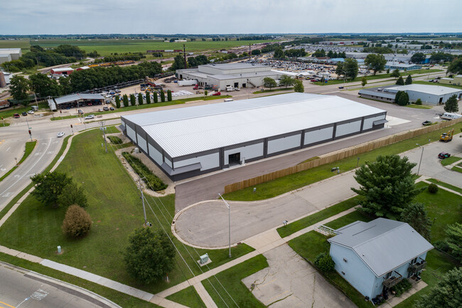
Property Record
2050 Beloit Ave, Janesville, WI 53546

NEARBY LISTINGS FOR SALE OR LEASE
Property Detail
2050 Beloit Ave
041-2300097
LOT 1 CSM #2079957 VOL. 38,PGS. 150-153; DAF PT OFSE1/4 NE1/4 SEC. 12; ALL ORPART OF LOTS 1, 2, 3, 4, 5 &6, BLK 6, SUNDOWN ACRES;ALSO CSM VOL. 30 PGS.205- 207#1763298 AND LOC INNE1/4 SE1/4 SEC. 12 T2NR12EALSO PT OF VACATED KELLOGGAVE & VACATED REUTHE
Commercialnec
Rock
X
Wisconsin
55105C0194E
1,1-6
2024
3.72 AC
2024
Rock County
000900
Milwaukee/Madison
2,760 SF
Janesville-Beloit, WI
DEMOGRAPHICS near 2050 Beloit Ave
1 Mile
3 Mile
5 Mile
2024 Total Population
2,373
28,151
60,698
2029 Population
2,386
28,365
61,041
Pop Growth 2024-2029
+ 0.55%
+ 0.76%
+ 0.57%
Average Age
39
40
41
2024 Total Households
970
11,781
25,698
HH Growth 2024-2029
+ 0.41%
+ 0.85%
+ 0.58%
Median Household Inc
$48,683
$59,224
$62,408
Avg Household Size
2.40
2.30
2.30
2024 Avg HH Vehicles
2.00
2.00
2.00
Median Home Value
$146,166
$159,022
$170,425
Median Year Built
1966
1963
1969
Nearby Places
Map Layers
Map Styles
 Street
 Aerial
- Restaurants
- Banks
- Shops
- Fitness
- Groceries
PUBLIC TRANSPORTATION
AIRPORT
Chicago/Rockford International
DRIVE
WALK
Distance
Chicago/Rockford International
54 min
41.7 mi
Dane County Regional/Truax Field
DRIVE
WALK
Distance
Dane County Regional/Truax Field
60 min
48.7 mi
Nearby Properties
Address
Land Use
TOTAL SIZE
Lot Size
Zoning
Address
Land Use
TOTAL SIZE
Lot Size
Zoning
2,580 SF
122.77 AC
M1
Address
Land Use
TOTAL SIZE
Lot Size
Zoning
56.41 AC
M2
Address
Land Use
TOTAL SIZE
Lot Size
Zoning
700,000 SF
50.74 AC
M1
Address
Land Use
TOTAL SIZE
Lot Size
Zoning
32,518 SF
26.74 AC
B4
Address
Land Use
TOTAL SIZE
Lot Size
Zoning
31,064 SF
11.57 AC
R3
Address
Land Use
TOTAL SIZE
Lot Size
Zoning
12,620 SF
8.05 AC
R3
Address
Land Use
TOTAL SIZE
Lot Size
Zoning
48,110 SF
13.04 AC
R3
Address
Land Use
TOTAL SIZE
Lot Size
Zoning
16,959 SF
47.11 AC
M1
Address
Land Use
TOTAL SIZE
Lot Size
Zoning
18,480 SF
14.50 AC
O1
Address
Land Use
TOTAL SIZE
Lot Size
Zoning
70,000 SF
63.05 AC
M1
Address
Land Use
TOTAL SIZE
Lot Size
Zoning
17.51 AC
M1
Address
Land Use
TOTAL SIZE
Lot Size
Zoning
24.75 AC
Address
Land Use
TOTAL SIZE
Lot Size
Zoning
250,000 SF
22.56 AC
M1
Address
Land Use
TOTAL SIZE
Lot Size
Zoning
44,638 SF
91.27 AC
M1
Address
Land Use
TOTAL SIZE
Lot Size
Zoning
161,629 SF
16.91 AC
M1
Address
Land Use
TOTAL SIZE
Lot Size
Zoning
178,710 SF
9.92 AC
M1
Address
Land Use
TOTAL SIZE
Lot Size
Zoning
178,710 SF
14.73 AC
M1
Address
Land Use
TOTAL SIZE
Lot Size
Zoning
12.42 AC
M1
Address
Land Use
TOTAL SIZE
Lot Size
Zoning
200,500 SF
22.73 AC
M1
Address
Land Use
TOTAL SIZE
Lot Size
Zoning
110,000 SF
14.14 AC
M1
Address
Land Use
TOTAL SIZE
Lot Size
Zoning
101,195 SF
1.40 AC
B6
Address
Land Use
TOTAL SIZE
Lot Size
Zoning
39,485 SF
10.70 AC
M1
Address
Land Use
TOTAL SIZE
Lot Size
Zoning
20.84 AC
M2
Address
Land Use
TOTAL SIZE
Lot Size
Zoning
2,480 SF
16.27 AC
M2
Address
Land Use
TOTAL SIZE
Lot Size
Zoning
49,524 SF
1.57 AC
B6
Address
Land Use
TOTAL SIZE
Lot Size
Zoning
9,246 SF
0.59 AC
B5
Address
Land Use
TOTAL SIZE
Lot Size
Zoning
12.44 AC
M1
Address
Land Use
TOTAL SIZE
Lot Size
Zoning
80,000 SF
9.68 AC
M2
Address
Land Use
TOTAL SIZE
Lot Size
Zoning
16,128 SF
8.57 AC
R3
Address
Land Use
TOTAL SIZE
Lot Size
Zoning
52,000 SF
12.16 AC
M2
The World's #1 Commercial Real Estate Marketplace
Connect with us
© 2025 CoStar Group
The information above has been obtained from sources believed reliable. While we do not doubt its accuracy we have not verified it and make no guarantee, warranty or representation about it. It is your responsibility to independently confirm its accuracy and completeness. Any projections, opinions, assumptions, or estimates used are for example only and do not represent the current or future performance of the property. The value of this transaction to you depends on tax and other factors which should be evaluated by your tax, financial, and legal advisors. You and your advisors should conduct a careful, independent investigation of the property to determine to your satisfaction the suitability of the property for your needs.