Property Record
2050 Cessna Dr, Vacaville, CA 95688
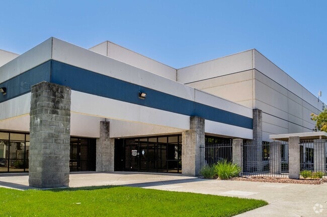

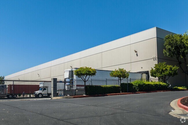
Property Detail
2050 Cessna Dr
0133-220-120
BK-BG 36-93 LOT 11
Warehouse
Solano
INDUSTRIAL
California
B and X Area of moderate flood hazard, usually the area between the limits of the 100-year and 500-year floods.
11
2024
12.45 AC
2025
Vacaville
252904
North Bay/Santa Rosa
218,100 SF
Vallejo, CA
NEARBY LISTINGS FOR SALE OR LEASE
DEMOGRAPHICS near 2050 Cessna Dr
1 mile
3 mile
5 mile
2025 Total Population
5,393
54,890
108,076
2030 Population
5,408
55,139
108,801
Pop Growth 2025-2030
+ 0.28%
+ 0.45%
+ 0.67%
Average Age
40
41
41
2025 Total Households
1,786
20,564
37,182
HH Growth 2025-2030
+ 0.22%
+ 0.53%
+ 0.70%
Median Household Inc
$163,968
$106,274
$112,911
Avg Household Size
2.90
2.60
2.70
2025 Avg HH Vehicles
3.00
2.00
2.00
Median Home Value
$779,042
$709,417
$717,044
Median Year Built
1992
1984
1984
Nearby Places
Map Layers
Map Styles
 Street
 Aerial
Layers
 Traffic
 Biking
Places
Listings with unknown addresses are not visible on the map
- Restaurants
- Banks
- Shops
- Fitness
- Groceries
PUBLIC TRANSPORTATION
COMMUTER RAIL
Drive
Walk
Distance
17 min
9.8 mi
AIRPORT
Sacramento International
Drive
Walk
Distance
Sacramento International
50 min
36.6 mi
Nearby Properties
Address
Land Use
TOTAL SIZE
Lot Size
Zoning
Address
Land Use
TOTAL SIZE
Lot Size
Zoning
Address
Land Use
TOTAL SIZE
Lot Size
Zoning
47.87 AC
Address
Land Use
TOTAL SIZE
Lot Size
Zoning
69.49 AC
Address
Land Use
TOTAL SIZE
Lot Size
Zoning
35.69 AC
Address
Land Use
TOTAL SIZE
Lot Size
Zoning
831,193 SF
68.78 AC
Address
Land Use
TOTAL SIZE
Lot Size
Zoning
12.64 AC
Address
Land Use
TOTAL SIZE
Lot Size
Zoning
332,833 SF
18.53 AC
Address
Land Use
TOTAL SIZE
Lot Size
Zoning
104,468 SF
1.30 AC
Address
Land Use
TOTAL SIZE
Lot Size
Zoning
210,900 SF
26.31 AC
Address
Land Use
TOTAL SIZE
Lot Size
Zoning
241,629 SF
9.99 AC
Address
Land Use
TOTAL SIZE
Lot Size
Zoning
151,756 SF
10.07 AC
Address
Land Use
TOTAL SIZE
Lot Size
Zoning
332,571 SF
8.35 AC
Address
Land Use
TOTAL SIZE
Lot Size
Zoning
332,571 SF
9.55 AC
Address
Land Use
TOTAL SIZE
Lot Size
Zoning
159,056 SF
11.07 AC
Address
Land Use
TOTAL SIZE
Lot Size
Zoning
7.69 AC
Address
Land Use
TOTAL SIZE
Lot Size
Zoning
224,536 SF
11.77 AC
CG W/RES O
Address
Land Use
TOTAL SIZE
Lot Size
Zoning
597,816 SF
32.25 AC
Address
Land Use
TOTAL SIZE
Lot Size
Zoning
11.52 AC
Address
Land Use
TOTAL SIZE
Lot Size
Zoning
173,016 SF
13.79 AC
Address
Land Use
TOTAL SIZE
Lot Size
Zoning
9.78 AC
Address
Land Use
TOTAL SIZE
Lot Size
Zoning
Address
Land Use
TOTAL SIZE
Lot Size
Zoning
164,256 SF
6.74 AC
Address
Land Use
TOTAL SIZE
Lot Size
Zoning
323,918 SF
7.18 AC
Address
Land Use
TOTAL SIZE
Lot Size
Zoning
321,651 SF
21.29 AC
Address
Land Use
TOTAL SIZE
Lot Size
Zoning
7,302 SF
17.10 AC
Address
Land Use
TOTAL SIZE
Lot Size
Zoning
242,472 SF
12.13 AC
Address
Land Use
TOTAL SIZE
Lot Size
Zoning
242,472 SF
12.39 AC
Address
Land Use
TOTAL SIZE
Lot Size
Zoning
323,918 SF
7.72 AC
Address
Land Use
TOTAL SIZE
Lot Size
Zoning
234,916 SF
11.25 AC
Address
Land Use
TOTAL SIZE
Lot Size
Zoning
252,423 SF
14.03 AC
The World's #1 Commercial Real Estate Marketplace
Connect with us
© 2026 CoStar Group
The information above has been obtained from sources believed reliable. While we do not doubt its accuracy we have not verified it and make no guarantee, warranty or representation about it. It is your responsibility to independently confirm its accuracy and completeness. Any projections, opinions, assumptions, or estimates used are for example only and do not represent the current or future performance of the property. The value of this transaction to you depends on tax and other factors which should be evaluated by your tax, financial, and legal advisors. You and your advisors should conduct a careful, independent investigation of the property to determine to your satisfaction the suitability of the property for your needs.