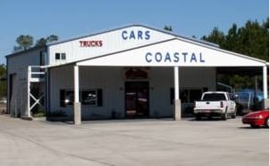
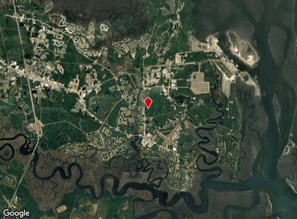
Property Record
2050 Village Dr E, Saint Marys, GA 31558
NEARBY LISTINGS FOR SALE OR LEASE
Property Detail
2050 Village Dr E
St. Marys, GA
COASTAL MOTOR CARS /L N/S HWY 40
121-003A001
Camden
Commercialnec
Georgia
2025
2.04 AC
2025
Brunswick/Kingsland
010500
Other Market Areas
4,161 SF
DEMOGRAPHICS near 2050 Village Dr E
1 Mile
3 Mile
5 Mile
2024 Total Population
1,614
23,815
41,598
2029 Population
1,812
26,154
45,582
Pop Growth 2024-2029
+ 12.27%
+ 9.82%
+ 9.58%
Average Age
34
36
36
2024 Total Households
607
8,993
15,042
HH Growth 2024-2029
+ 12.36%
+ 9.94%
+ 9.77%
Median Household Inc
$53,255
$71,840
$64,255
Avg Household Size
2.60
2.60
2.60
2024 Avg HH Vehicles
2.00
2.00
2.00
Median Home Value
$195,237
$236,994
$222,754
Median Year Built
1997
1999
1996
Nearby Places
Map Layers
Map Styles
 Street
 Aerial
- Restaurants
- Banks
- Shops
- Fitness
- Groceries
PUBLIC TRANSPORTATION
AIRPORT
Jacksonville International
DRIVE
WALK
Distance
Jacksonville International
52 min
33.7 mi
Freight Ports
Georgia Ports - Brunswick
DRIVE
WALK
Distance
Georgia Ports - Brunswick
59 min
40.7 mi
SALE & LEASE HISTORY
LISTING DATE
SALE/LEASE

Sep 24, 2016
For Sale
Nearby Properties
Address
Land Use
TOTAL SIZE
Lot Size
Zoning
Address
Land Use
TOTAL SIZE
Lot Size
Zoning
2,856 SF
51.84 AC
R-3
Address
Land Use
TOTAL SIZE
Lot Size
Zoning
172,807 SF
45.10 AC
R-1
Address
Land Use
TOTAL SIZE
Lot Size
Zoning
1,456 SF
15.71 AC
R-3
Address
Land Use
TOTAL SIZE
Lot Size
Zoning
26,410 SF
3.21 AC
C-3
Address
Land Use
TOTAL SIZE
Lot Size
Zoning
80,350 SF
28 AC
PD
Address
Land Use
TOTAL SIZE
Lot Size
Zoning
14,152 SF
14.25 AC
R-3
Address
Land Use
TOTAL SIZE
Lot Size
Zoning
64,504 SF
20 AC
C-ED
Address
Land Use
TOTAL SIZE
Lot Size
Zoning
64,810 SF
21 AC
R-1
Address
Land Use
TOTAL SIZE
Lot Size
Zoning
87,534 SF
25 AC
PD
Address
Land Use
TOTAL SIZE
Lot Size
Zoning
2,305 SF
20.92 AC
C-2
Address
Land Use
TOTAL SIZE
Lot Size
Zoning
9,744 SF
13.84 AC
R-3
Address
Land Use
TOTAL SIZE
Lot Size
Zoning
5 AC
C-3
Address
Land Use
TOTAL SIZE
Lot Size
Zoning
28,858 SF
5.09 AC
R-3
Address
Land Use
TOTAL SIZE
Lot Size
Zoning
3,240 SF
13.97 AC
R-1
Address
Land Use
TOTAL SIZE
Lot Size
Zoning
31,428 SF
5.80 AC
R-2
Address
Land Use
TOTAL SIZE
Lot Size
Zoning
182,489 SF
22.88 AC
C-2
Address
Land Use
TOTAL SIZE
Lot Size
Zoning
77,912 SF
12.76 AC
C-2
Address
Land Use
TOTAL SIZE
Lot Size
Zoning
22,311 SF
6.39 AC
C-2
Address
Land Use
TOTAL SIZE
Lot Size
Zoning
11,086 SF
6.26 AC
R-3
Address
Land Use
TOTAL SIZE
Lot Size
Zoning
54,408 SF
15.57 AC
I-A
Address
Land Use
TOTAL SIZE
Lot Size
Zoning
45,180 SF
7.46 AC
C-2
Address
Land Use
TOTAL SIZE
Lot Size
Zoning
1,530 SF
5.97 AC
C-2
Address
Land Use
TOTAL SIZE
Lot Size
Zoning
6,720 SF
25 AC
R-3
Address
Land Use
TOTAL SIZE
Lot Size
Zoning
18,025 SF
12.47 AC
C-2
Address
Land Use
TOTAL SIZE
Lot Size
Zoning
92,858 SF
10.67 AC
C-2
Address
Land Use
TOTAL SIZE
Lot Size
Zoning
451,960 SF
40.62 AC
I-G
Address
Land Use
TOTAL SIZE
Lot Size
Zoning
31,224 SF
11.43 AC
PD R-3
Address
Land Use
TOTAL SIZE
Lot Size
Zoning
12,560 SF
4.93 AC
C-2
Address
Land Use
TOTAL SIZE
Lot Size
Zoning
31,040 SF
4.48 AC
I-L
Address
Land Use
TOTAL SIZE
Lot Size
Zoning
2,220 SF
3.64 AC
I-L
The World's #1 Commercial Real Estate Marketplace
Connect with us
© 2025 CoStar Group
The information above has been obtained from sources believed reliable. While we do not doubt its accuracy we have not verified it and make no guarantee, warranty or representation about it. It is your responsibility to independently confirm its accuracy and completeness. Any projections, opinions, assumptions, or estimates used are for example only and do not represent the current or future performance of the property. The value of this transaction to you depends on tax and other factors which should be evaluated by your tax, financial, and legal advisors. You and your advisors should conduct a careful, independent investigation of the property to determine to your satisfaction the suitability of the property for your needs.