Property Record
2000 N Arizona Ave, Chandler, AZ 85225

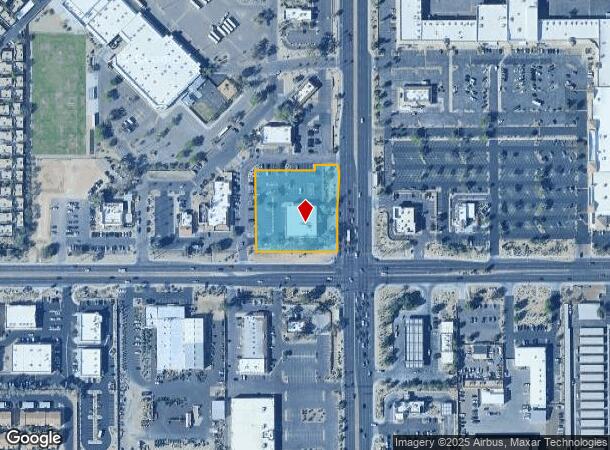
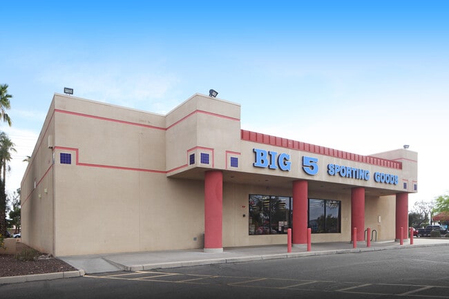
This Property Is For Sale
NEARBY LISTINGS FOR SALE OR LEASE
Property Detail
2000 N Arizona Ave
302-28-007X
THAT PT SE4 SE4 SEC 16 DESC AS EXCEPTION PARCEL E P/F 93-462607 EX S 15F TH/OF & EX COM SE COR SEC 16 TH N 355.50F W 55F TO TPOB TH N 78D 48M W 10.70F S 16.51F E 4F S 17.15F S 3D 42M W 112.72F S 136.55F TO N LN OF S 75F SE4 SEC 16 TH E 14F TH N 280.5
Storebuilding
Maricopa
X
Arizona
04013C2729M
1.67 AC
2025
Chandler
2025
Phoenix
422209
Phoenix-Mesa-Scottsdale, AZ
10,000 SF
DEMOGRAPHICS near 2000 N Arizona Ave
1 Mile
3 Mile
5 Mile
2024 Total Population
17,647
141,974
367,306
2029 Population
19,071
152,444
395,361
Pop Growth 2024-2029
+ 8.07%
+ 7.37%
+ 7.64%
Average Age
36
38
37
2024 Total Households
7,165
53,505
138,155
HH Growth 2024-2029
+ 8.14%
+ 7.46%
+ 7.74%
Median Household Inc
$71,666
$81,685
$82,902
Avg Household Size
2.40
2.60
2.60
2024 Avg HH Vehicles
2.00
2.00
2.00
Median Home Value
$302,697
$362,810
$379,764
Median Year Built
1989
1988
1988
Nearby Places
- Restaurants
- Banks
- Shops
- Fitness
- Groceries
PUBLIC TRANSPORTATION
AIRPORT
Phoenix Sky Harbor International
DRIVE
WALK
Distance
Phoenix Sky Harbor International
23 min
16.6 mi
Nearby Properties
Address
Land Use
TOTAL SIZE
Lot Size
Zoning
Address
Land Use
TOTAL SIZE
Lot Size
Zoning
1,418,890 SF
39 AC
PF
Address
Land Use
TOTAL SIZE
Lot Size
Zoning
1.13 AC
Address
Land Use
TOTAL SIZE
Lot Size
Zoning
301,190 SF
77.17 AC
PF
Address
Land Use
TOTAL SIZE
Lot Size
Zoning
984,487 SF
37.54 AC
I-1
Address
Land Use
TOTAL SIZE
Lot Size
Zoning
15,066 SF
2.54 AC
PAD
Address
Land Use
TOTAL SIZE
Lot Size
Zoning
416,954 SF
9.59 AC
PF
Address
Land Use
TOTAL SIZE
Lot Size
Zoning
739,944 SF
40.02 AC
MFM
Address
Land Use
TOTAL SIZE
Lot Size
Zoning
348,249 SF
6.42 AC
M-H
Address
Land Use
TOTAL SIZE
Lot Size
Zoning
9.25 AC
I-1
Address
Land Use
TOTAL SIZE
Lot Size
Zoning
411,683 SF
15.53 AC
RM3
Address
Land Use
TOTAL SIZE
Lot Size
Zoning
22,149 SF
6.33 AC
PAD
Address
Land Use
TOTAL SIZE
Lot Size
Zoning
348,379 SF
6.49 AC
PAD
Address
Land Use
TOTAL SIZE
Lot Size
Zoning
112,628 SF
17.37 AC
I-1
Address
Land Use
TOTAL SIZE
Lot Size
Zoning
309,031 SF
18.55 AC
Address
Land Use
TOTAL SIZE
Lot Size
Zoning
16.57 AC
PF
Address
Land Use
TOTAL SIZE
Lot Size
Zoning
185,744 SF
36.64 AC
PF
Address
Land Use
TOTAL SIZE
Lot Size
Zoning
372,953 SF
14.36 AC
C-C
Address
Land Use
TOTAL SIZE
Lot Size
Zoning
357,691 SF
19.87 AC
PAD
Address
Land Use
TOTAL SIZE
Lot Size
Zoning
272,380 SF
15.30 AC
PAD
Address
Land Use
TOTAL SIZE
Lot Size
Zoning
358,620 SF
18.72 AC
PAD
Address
Land Use
TOTAL SIZE
Lot Size
Zoning
253,276 SF
18.33 AC
PAD
Address
Land Use
TOTAL SIZE
Lot Size
Zoning
118,172 SF
25.30 AC
SCHOOL
Address
Land Use
TOTAL SIZE
Lot Size
Zoning
273,805 SF
7.73 AC
MF-2
Address
Land Use
TOTAL SIZE
Lot Size
Zoning
115,920 SF
18.19 AC
Address
Land Use
TOTAL SIZE
Lot Size
Zoning
154,816 SF
35.89 AC
I-1
Address
Land Use
TOTAL SIZE
Lot Size
Zoning
291,604 SF
18.67 AC
PAD
Address
Land Use
TOTAL SIZE
Lot Size
Zoning
109,909 SF
2.33 AC
C3
Address
Land Use
TOTAL SIZE
Lot Size
Zoning
270,243 SF
15.52 AC
M-M
Address
Land Use
TOTAL SIZE
Lot Size
Zoning
229,536 SF
13.94 AC
PAD
Address
Land Use
TOTAL SIZE
Lot Size
Zoning
144,246 SF
1.82 AC
PAD
The World's #1 Commercial Real Estate Marketplace
Connect with us
© 2025 CoStar Group
The information above has been obtained from sources believed reliable. While we do not doubt its accuracy we have not verified it and make no guarantee, warranty or representation about it. It is your responsibility to independently confirm its accuracy and completeness. Any projections, opinions, assumptions, or estimates used are for example only and do not represent the current or future performance of the property. The value of this transaction to you depends on tax and other factors which should be evaluated by your tax, financial, and legal advisors. You and your advisors should conduct a careful, independent investigation of the property to determine to your satisfaction the suitability of the property for your needs.