Property Record
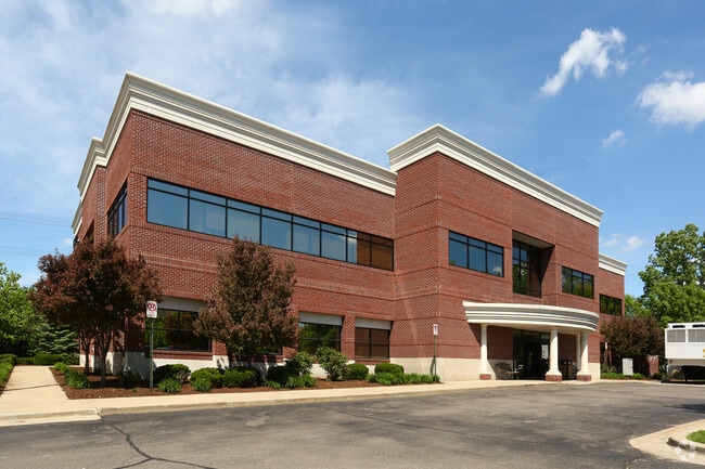
2050 N Haggerty Rd, Canton, MI 48187


Current Lease Availabilities
NEARBY LISTINGS FOR SALE OR LEASE
Property Detail
2050 N Haggerty Rd
Detroit-Warren-Dearborn, MI
Canton Commercial Centre
71-050-01-0004-000
13C4 UNIT 4 WAYNE COUNTY COND SUB PLAN NO. 575 AKA CANTON COMMERCIAL CENTRE T2S R8E L 32703 OF DEEDS P 455 TO 508 WCR WAYNE
Officebuilding
Wayne
X
Michigan
26163C0204E
0004
2025
2.09 AC
2025
Southern I-275 Corridor
564100
Detroit
23,820 SF
DEMOGRAPHICS near 2050 N Haggerty Rd
1 mile
3 mile
5 mile
2024 Total Population
10,103
88,811
204,664
2029 Population
9,621
84,943
196,621
Pop Growth 2024-2029
(4.77%)
(4.36%)
(3.93%)
Average Age
40
41
41
2024 Total Households
4,166
36,065
84,068
HH Growth 2024-2029
(4.75%)
(4.35%)
(3.92%)
Median Household Inc
$75,248
$83,804
$82,083
Avg Household Size
2.40
2.40
2.40
2024 Avg HH Vehicles
2.00
2.00
2.00
Median Home Value
$255,904
$253,429
$250,806
Median Year Built
1977
1978
1976
Nearby Places
Map Layers
Map Styles
 Street
 Aerial
Transit
 Traffic
 Biking
Places
Listings with unknown addresses are not visible on the map
- Restaurants
- Banks
- Shops
- Fitness
- Groceries
PUBLIC TRANSPORTATION
AIRPORT
Detroit Metro Wayne County
Drive
Walk
Distance
Detroit Metro Wayne County
24 min
15.2 mi
Windsor International
Drive
Walk
Distance
Windsor International
56 min
37.5 mi
Freight Ports
Drive
Walk
Distance
69 min
55.6 mi
Nearby Properties
Address
Land Use
TOTAL SIZE
Lot Size
Zoning
Address
Land Use
TOTAL SIZE
Lot Size
Zoning
741,173 SF
63.81 AC
Address
Land Use
TOTAL SIZE
Lot Size
Zoning
17.50 AC
R-2
Address
Land Use
TOTAL SIZE
Lot Size
Zoning
400,857 SF
27.44 AC
RP
Address
Land Use
TOTAL SIZE
Lot Size
Zoning
37.30 AC
MR
Address
Land Use
TOTAL SIZE
Lot Size
Zoning
39.50 AC
MR
Address
Land Use
TOTAL SIZE
Lot Size
Zoning
176,796 SF
17.08 AC
C-2
Address
Land Use
TOTAL SIZE
Lot Size
Zoning
167,491 SF
18.59 AC
Address
Land Use
TOTAL SIZE
Lot Size
Zoning
408,122 SF
23.31 AC
MR
Address
Land Use
TOTAL SIZE
Lot Size
Zoning
425,019 SF
37.96 AC
Address
Land Use
TOTAL SIZE
Lot Size
Zoning
21.71 AC
MR
Address
Land Use
TOTAL SIZE
Lot Size
Zoning
311,556 SF
23.17 AC
C-3
Address
Land Use
TOTAL SIZE
Lot Size
Zoning
114,894 SF
4.94 AC
ARC
Address
Land Use
TOTAL SIZE
Lot Size
Zoning
352,514 SF
26.40 AC
Address
Land Use
TOTAL SIZE
Lot Size
Zoning
24.63 AC
MR
Address
Land Use
TOTAL SIZE
Lot Size
Zoning
20.91 AC
Address
Land Use
TOTAL SIZE
Lot Size
Zoning
395,148 SF
9.67 AC
Address
Land Use
TOTAL SIZE
Lot Size
Zoning
169,489 SF
14.51 AC
R-6
Address
Land Use
TOTAL SIZE
Lot Size
Zoning
206,896 SF
19.49 AC
R-6
Address
Land Use
TOTAL SIZE
Lot Size
Zoning
Address
Land Use
TOTAL SIZE
Lot Size
Zoning
954,882 SF
47.92 AC
LI-2
Address
Land Use
TOTAL SIZE
Lot Size
Zoning
169,968 SF
12.46 AC
MR
Address
Land Use
TOTAL SIZE
Lot Size
Zoning
249,795 SF
21.17 AC
Address
Land Use
TOTAL SIZE
Lot Size
Zoning
186,967 SF
9.75 AC
Address
Land Use
TOTAL SIZE
Lot Size
Zoning
11.40 AC
MR
Address
Land Use
TOTAL SIZE
Lot Size
Zoning
16.03 AC
MR
Address
Land Use
TOTAL SIZE
Lot Size
Zoning
147,968 SF
16.68 AC
Address
Land Use
TOTAL SIZE
Lot Size
Zoning
66,670 SF
11.20 AC
C-3
Address
Land Use
TOTAL SIZE
Lot Size
Zoning
243,371 SF
16.04 AC
Address
Land Use
TOTAL SIZE
Lot Size
Zoning
269,649 SF
18.27 AC
LI-1
Address
Land Use
TOTAL SIZE
Lot Size
Zoning
76,430 SF
13.61 AC
C-3
The World's #1 Commercial Real Estate Marketplace
Connect with us
© 2026 CoStar Group
The information above has been obtained from sources believed reliable. While we do not doubt its accuracy we have not verified it and make no guarantee, warranty or representation about it. It is your responsibility to independently confirm its accuracy and completeness. Any projections, opinions, assumptions, or estimates used are for example only and do not represent the current or future performance of the property. The value of this transaction to you depends on tax and other factors which should be evaluated by your tax, financial, and legal advisors. You and your advisors should conduct a careful, independent investigation of the property to determine to your satisfaction the suitability of the property for your needs.