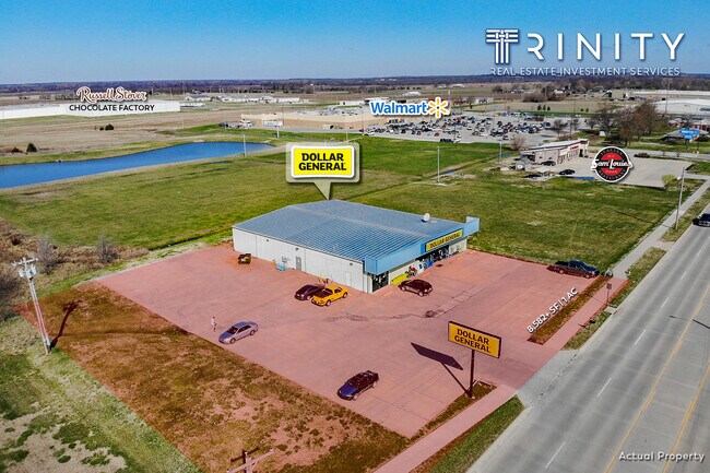
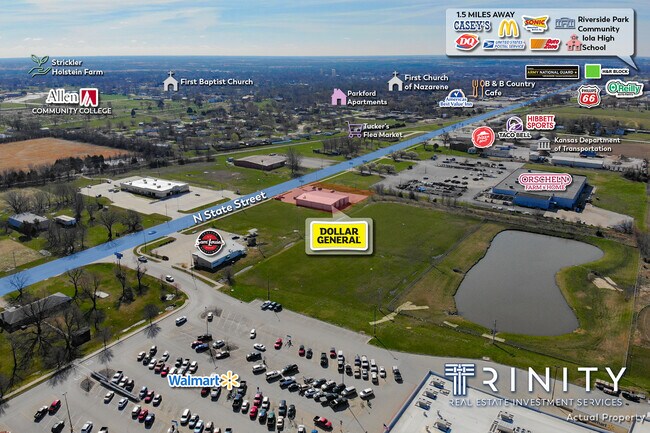
Property Record
2050 N State St, Iola, KS 66749

Property Detail
2050 N State St
075-22-0-40-01-013.01-0
S22, T24, R18, ACRES 1, BEG 1346.1' (1342.97' SURVEYED) N OF SE SEC COR, W 243.7', N 209', E 243.7', S 209', TO POB EX RD R/W
Wholesaleoutletdiscountstore
Allen
B and X Area of moderate flood hazard, usually the area between the limits of the 100-year and 500-year floods.
Kansas
2024
0.95 AC
2025
Kansas Area
952800
Other Market Areas
8,600 SF
NEARBY LISTINGS FOR SALE OR LEASE
-
-
View all Iola listings for sale on LoopNet.com
DEMOGRAPHICS near 2050 N State St
1 mile
3 mile
5 mile
2025 Total Population
1,986
6,213
7,065
2030 Population
1,984
6,195
6,999
Pop Growth 2025-2030
(0.10%)
(0.29%)
(0.93%)
Average Age
40
41
41
2025 Total Households
784
2,617
2,961
HH Growth 2025-2030
(0.13%)
(0.31%)
(0.84%)
Median Household Inc
$54,020
$52,079
$53,003
Avg Household Size
2.30
2.20
2.20
2025 Avg HH Vehicles
2.00
2.00
2.00
Median Home Value
$121,595
$94,551
$99,088
Median Year Built
1974
1964
1966
Nearby Places
Map Layers
Map Styles
 Street
 Aerial
Layers
 Traffic
 Biking
Places
Listings with unknown addresses are not visible on the map
- Restaurants
- Banks
- Shops
- Fitness
- Groceries
SALE & LEASE HISTORY
LISTING DATE
SALE/LEASE

May 01, 2020
For Sale
Jun 02, 2021
For Sale
Nearby Properties
Address
Land Use
TOTAL SIZE
Lot Size
Zoning
Address
Land Use
TOTAL SIZE
Lot Size
Zoning
61,470 SF
30.60 AC
Address
Land Use
TOTAL SIZE
Lot Size
Zoning
158,240 SF
74.73 AC
Address
Land Use
TOTAL SIZE
Lot Size
Zoning
1,920 SF
15.70 AC
Address
Land Use
TOTAL SIZE
Lot Size
Zoning
81,116 SF
2.28 AC
Address
Land Use
TOTAL SIZE
Lot Size
Zoning
75,128 SF
30.90 AC
Address
Land Use
TOTAL SIZE
Lot Size
Zoning
13,562 SF
4.94 AC
Address
Land Use
TOTAL SIZE
Lot Size
Zoning
53,950 SF
3.30 AC
Address
Land Use
TOTAL SIZE
Lot Size
Zoning
75,840 SF
2.55 AC
Address
Land Use
TOTAL SIZE
Lot Size
Zoning
39,675 SF
0.53 AC
Address
Land Use
TOTAL SIZE
Lot Size
Zoning
11,832 SF
1.29 AC
Address
Land Use
TOTAL SIZE
Lot Size
Zoning
70,362 SF
25.04 AC
Address
Land Use
TOTAL SIZE
Lot Size
Zoning
18,440 SF
57.70 AC
Address
Land Use
TOTAL SIZE
Lot Size
Zoning
33,318 SF
11.80 AC
Address
Land Use
TOTAL SIZE
Lot Size
Zoning
46,982 SF
1.24 AC
Address
Land Use
TOTAL SIZE
Lot Size
Zoning
18,706 SF
9 AC
Address
Land Use
TOTAL SIZE
Lot Size
Zoning
38,171 SF
3.99 AC
Address
Land Use
TOTAL SIZE
Lot Size
Zoning
29,740 SF
55 AC
Address
Land Use
TOTAL SIZE
Lot Size
Zoning
282,308 SF
101.96 AC
Address
Land Use
TOTAL SIZE
Lot Size
Zoning
105,648 SF
12.06 AC
Address
Land Use
TOTAL SIZE
Lot Size
Zoning
12,402 SF
0.46 AC
Address
Land Use
TOTAL SIZE
Lot Size
Zoning
21,401 SF
1.80 AC
Address
Land Use
TOTAL SIZE
Lot Size
Zoning
8,000 SF
0.23 AC
Address
Land Use
TOTAL SIZE
Lot Size
Zoning
33,520 SF
1.55 AC
Address
Land Use
TOTAL SIZE
Lot Size
Zoning
34,888 SF
1.31 AC
Address
Land Use
TOTAL SIZE
Lot Size
Zoning
72,072 SF
0.58 AC
Address
Land Use
TOTAL SIZE
Lot Size
Zoning
7,448 SF
11.60 AC
Address
Land Use
TOTAL SIZE
Lot Size
Zoning
12,300 SF
0.59 AC
Address
Land Use
TOTAL SIZE
Lot Size
Zoning
6,840 SF
0.23 AC
Address
Land Use
TOTAL SIZE
Lot Size
Zoning
14,433 SF
1.90 AC
Address
Land Use
TOTAL SIZE
Lot Size
Zoning
6,300 SF
0.24 AC
The World's #1 Commercial Real Estate Marketplace
Connect with us
© 2026 CoStar Group
The information above has been obtained from sources believed reliable. While we do not doubt its accuracy we have not verified it and make no guarantee, warranty or representation about it. It is your responsibility to independently confirm its accuracy and completeness. Any projections, opinions, assumptions, or estimates used are for example only and do not represent the current or future performance of the property. The value of this transaction to you depends on tax and other factors which should be evaluated by your tax, financial, and legal advisors. You and your advisors should conduct a careful, independent investigation of the property to determine to your satisfaction the suitability of the property for your needs.