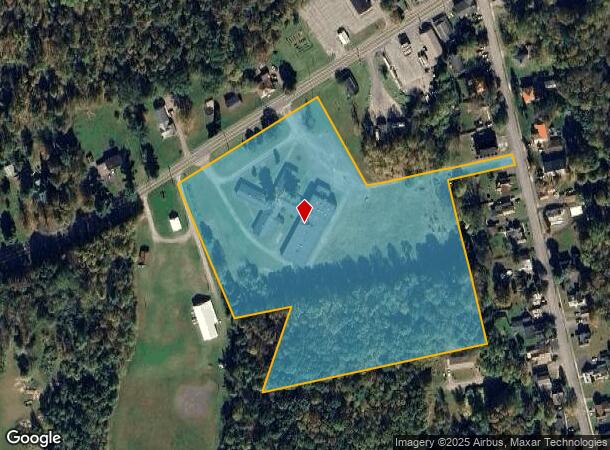
Property Record
2050 Nys Rte 49 S, Blossvale, NY 13308
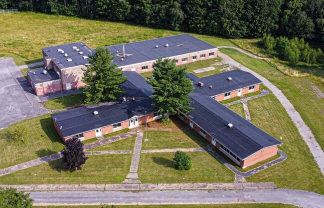
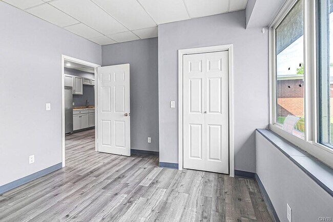
This Property Is For Sale
NEARBY LISTINGS FOR SALE OR LEASE
-
-
View all Blossvale listings for sale on LoopNet.com
Property Detail
2050 Nys Rte 49 S
217-017-0001-053-000-0000
CAMDEN AT NORTH BAY
Commercialbuilding
Oneida
X
New York
36065C0482F
53.000
2025
9.65 AC
2024
Outlying Oneida County
026700
Utica/Rome
32,000 SF
Utica-Rome, NY
DEMOGRAPHICS near 2050 Nys Rte 49 S
1 Mile
3 Mile
5 Mile
2024 Total Population
371
2,713
5,692
2029 Population
376
2,671
5,666
Pop Growth 2024-2029
+ 1.35%
(1.55%)
(0.46%)
Average Age
47
47
46
2024 Total Households
169
1,228
2,450
HH Growth 2024-2029
+ 1.18%
(1.79%)
(0.61%)
Median Household Inc
$63,055
$57,712
$63,602
Avg Household Size
2.10
2.20
2.30
2024 Avg HH Vehicles
2.00
2.00
2.00
Median Home Value
$150,961
$133,246
$131,931
Median Year Built
1955
1958
1960
Nearby Places
Map Layers
Map Styles
 Street
 Aerial
- Restaurants
- Banks
- Shops
- Fitness
- Groceries
PUBLIC TRANSPORTATION
AIRPORT
Syracuse Hancock International
DRIVE
WALK
Distance
Syracuse Hancock International
50 min
34.8 mi
Freight Ports
Albany, NY Port
DRIVE
WALK
Distance
Albany, NY Port
156 min
128.3 mi
Nearby Properties
Address
Land Use
TOTAL SIZE
Lot Size
Zoning
Address
Land Use
TOTAL SIZE
Lot Size
Zoning
900 SF
28.06 AC
H
Address
Land Use
TOTAL SIZE
Lot Size
Zoning
4,000 SF
4.10 AC
01 - NOT Z
Address
Land Use
TOTAL SIZE
Lot Size
Zoning
5,692 SF
17.70 AC
V
Address
Land Use
TOTAL SIZE
Lot Size
Zoning
12,988 SF
V
Address
Land Use
TOTAL SIZE
Lot Size
Zoning
1,440 SF
77.40 AC
H
Address
Land Use
TOTAL SIZE
Lot Size
Zoning
17,583 SF
0.50 AC
V
Address
Land Use
TOTAL SIZE
Lot Size
Zoning
Address
Land Use
TOTAL SIZE
Lot Size
Zoning
6,440 SF
1.81 AC
V
Address
Land Use
TOTAL SIZE
Lot Size
Zoning
Address
Land Use
TOTAL SIZE
Lot Size
Zoning
1,215 SF
3.61 AC
V
Address
Land Use
TOTAL SIZE
Lot Size
Zoning
5,000 SF
28.31 AC
C
Address
Land Use
TOTAL SIZE
Lot Size
Zoning
10,732 SF
1.50 AC
V
Address
Land Use
TOTAL SIZE
Lot Size
Zoning
864 SF
44.45 AC
WR
Address
Land Use
TOTAL SIZE
Lot Size
Zoning
400 SF
19.50 AC
WR
Address
Land Use
TOTAL SIZE
Lot Size
Zoning
1,155 SF
3 AC
V
Address
Land Use
TOTAL SIZE
Lot Size
Zoning
2,500 SF
2.98 AC
C
Address
Land Use
TOTAL SIZE
Lot Size
Zoning
4,960 SF
6.50 AC
V
Address
Land Use
TOTAL SIZE
Lot Size
Zoning
4.20 AC
V
Address
Land Use
TOTAL SIZE
Lot Size
Zoning
3.50 AC
V
Address
Land Use
TOTAL SIZE
Lot Size
Zoning
10,000 SF
127.12 AC
C
Address
Land Use
TOTAL SIZE
Lot Size
Zoning
0.59 AC
V
Address
Land Use
TOTAL SIZE
Lot Size
Zoning
4,080 SF
4.70 AC
V
Address
Land Use
TOTAL SIZE
Lot Size
Zoning
7,538 SF
0.91 AC
V
Address
Land Use
TOTAL SIZE
Lot Size
Zoning
0.01 AC
C
Address
Land Use
TOTAL SIZE
Lot Size
Zoning
13,236 SF
V
Address
Land Use
TOTAL SIZE
Lot Size
Zoning
9,204 SF
0.94 AC
V
Address
Land Use
TOTAL SIZE
Lot Size
Zoning
7,400 SF
4.01 AC
C
Address
Land Use
TOTAL SIZE
Lot Size
Zoning
6,906 SF
0.69 AC
V
Address
Land Use
TOTAL SIZE
Lot Size
Zoning
6,120 SF
0.14 AC
V
Address
Land Use
TOTAL SIZE
Lot Size
Zoning
8,400 SF
4.50 AC
V
The World's #1 Commercial Real Estate Marketplace
Connect with us
© 2026 CoStar Group
The information above has been obtained from sources believed reliable. While we do not doubt its accuracy we have not verified it and make no guarantee, warranty or representation about it. It is your responsibility to independently confirm its accuracy and completeness. Any projections, opinions, assumptions, or estimates used are for example only and do not represent the current or future performance of the property. The value of this transaction to you depends on tax and other factors which should be evaluated by your tax, financial, and legal advisors. You and your advisors should conduct a careful, independent investigation of the property to determine to your satisfaction the suitability of the property for your needs.