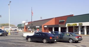
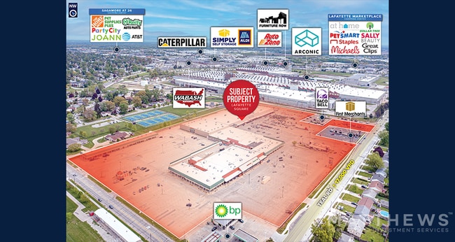
Property Record
2050 S 22Nd St, Lafayette, IN 47905
NEARBY LISTINGS FOR SALE OR LEASE
Property Detail
2050 S 22Nd St
79-07-33-276-009.000-004
PT NE SEC 33 TWP 23 R4 1.39A
Regionalshoppingcenterormallwithanchorstore
Tippecanoe
X
Indiana
18157C0163E
1
2024
1.39 AC
2024
Lafayette/Kokomo
001200
Other Market Areas
245,034 SF
Lafayette-West Lafayette, IN
DEMOGRAPHICS near 2050 S 22Nd St
1 Mile
3 Mile
5 Mile
2024 Total Population
10,287
82,176
128,666
2029 Population
10,539
84,680
132,641
Pop Growth 2024-2029
+ 2.45%
+ 3.05%
+ 3.09%
Average Age
37
35
35
2024 Total Households
4,344
35,748
51,653
HH Growth 2024-2029
+ 2.58%
+ 3.24%
+ 3.44%
Median Household Inc
$50,596
$43,836
$47,820
Avg Household Size
2.30
2.20
2.20
2024 Avg HH Vehicles
2.00
2.00
2.00
Median Home Value
$119,857
$150,292
$175,460
Median Year Built
1959
1976
1980
Nearby Places
Map Layers
Map Styles
 Street
 Aerial
- Restaurants
- Banks
- Shops
- Fitness
- Groceries
PUBLIC TRANSPORTATION
COMMUTER RAIL
Lafayette Amtrak Station (Cardinal - Amtrak)
DRIVE
WALK
Distance
Lafayette Amtrak Station (Cardinal - Amtrak)
6 min
3.0 mi
Freight Ports
Port Milwaukee
DRIVE
WALK
Distance
Port Milwaukee
252 min
209.6 mi
SALE & LEASE HISTORY
LISTING DATE
SALE/LEASE

Sep 25, 2016
For Lease
May 22, 2023
For Sale
Nearby Properties
Address
Land Use
TOTAL SIZE
Lot Size
Zoning
Address
Land Use
TOTAL SIZE
Lot Size
Zoning
469,872 SF
0.85 AC
Address
Land Use
TOTAL SIZE
Lot Size
Zoning
68,943 SF
0.01 AC
Address
Land Use
TOTAL SIZE
Lot Size
Zoning
385,162 SF
1 AC
Address
Land Use
TOTAL SIZE
Lot Size
Zoning
401,345 SF
1.64 AC
Address
Land Use
TOTAL SIZE
Lot Size
Zoning
249,214 SF
1.93 AC
Address
Land Use
TOTAL SIZE
Lot Size
Zoning
117,351 SF
44 SF
Address
Land Use
TOTAL SIZE
Lot Size
Zoning
210,829 SF
87 SF
Address
Land Use
TOTAL SIZE
Lot Size
Zoning
32.01 AC
Address
Land Use
TOTAL SIZE
Lot Size
Zoning
232,565 SF
1.15 AC
Address
Land Use
TOTAL SIZE
Lot Size
Zoning
270,827 SF
34.90 AC
Address
Land Use
TOTAL SIZE
Lot Size
Zoning
1,449,360 SF
0.01 AC
Address
Land Use
TOTAL SIZE
Lot Size
Zoning
205,701 SF
1.27 AC
Address
Land Use
TOTAL SIZE
Lot Size
Zoning
77,226 SF
0.01 AC
Address
Land Use
TOTAL SIZE
Lot Size
Zoning
27,300 SF
22.52 AC
Address
Land Use
TOTAL SIZE
Lot Size
Zoning
164,234 SF
0.88 AC
Address
Land Use
TOTAL SIZE
Lot Size
Zoning
184,441 SF
44 SF
Address
Land Use
TOTAL SIZE
Lot Size
Zoning
222,276 SF
0.31 AC
Address
Land Use
TOTAL SIZE
Lot Size
Zoning
203,830 SF
18.73 AC
Address
Land Use
TOTAL SIZE
Lot Size
Zoning
267,379 SF
87 SF
Address
Land Use
TOTAL SIZE
Lot Size
Zoning
518,808 SF
174 SF
Address
Land Use
TOTAL SIZE
Lot Size
Zoning
140,973 SF
131 SF
Address
Land Use
TOTAL SIZE
Lot Size
Zoning
118,066 SF
0.80 AC
Address
Land Use
TOTAL SIZE
Lot Size
Zoning
25,476 SF
131 SF
Address
Land Use
TOTAL SIZE
Lot Size
Zoning
135,090 SF
0.80 AC
Address
Land Use
TOTAL SIZE
Lot Size
Zoning
340,790 SF
131 SF
Address
Land Use
TOTAL SIZE
Lot Size
Zoning
70,686 SF
25.67 AC
Address
Land Use
TOTAL SIZE
Lot Size
Zoning
1,409,410 SF
170.04 AC
Address
Land Use
TOTAL SIZE
Lot Size
Zoning
295,530 SF
87 SF
Address
Land Use
TOTAL SIZE
Lot Size
Zoning
286,889 SF
17.89 AC
The World's #1 Commercial Real Estate Marketplace
Connect with us
© 2026 CoStar Group
The information above has been obtained from sources believed reliable. While we do not doubt its accuracy we have not verified it and make no guarantee, warranty or representation about it. It is your responsibility to independently confirm its accuracy and completeness. Any projections, opinions, assumptions, or estimates used are for example only and do not represent the current or future performance of the property. The value of this transaction to you depends on tax and other factors which should be evaluated by your tax, financial, and legal advisors. You and your advisors should conduct a careful, independent investigation of the property to determine to your satisfaction the suitability of the property for your needs.