Property Record
2050 W Co Highway 30A W, Santa Rosa Beach, FL 32459
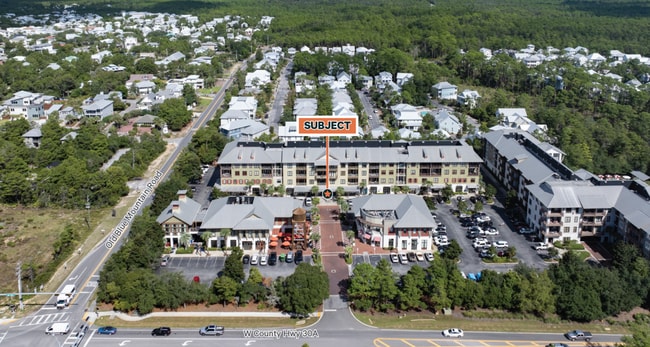

This Property Is For Sale
NEARBY LISTINGS FOR SALE OR LEASE
Property Detail
2050 W Co Highway 30A W
Crestview-Fort Walton Beach-Destin, FL
M1-210 Redfish Village Condo
12-3S-20-34860-0M1-0210
UNIT M1-210 REDFISH VILLAGE CONDO & A FRACTIONAL INT IN ALL COMMON AREAS & APPURTENANT LIMITED COMMON ELEMENTS AS RECD OR 2760-3580 OR 2781-3193 OR 2856-1815 OR 2857-1085 OR 2860-3378 OR 2865-3696 OR 2884-236 OR 3012-4648 OR 3027-2469 OR 3203-339 OR
Commercialcondominium
Walton
X
Florida
12131C0679H
210
2025
0.01 AC
2025
Florida Panhandle Area
950606
Other Market Areas
DEMOGRAPHICS near 2050 W Co Highway 30A W
1 Mile
3 Mile
5 Mile
2024 Total Population
2,615
6,648
17,645
2029 Population
3,485
8,779
22,777
Pop Growth 2024-2029
+ 33.27%
+ 32.05%
+ 29.08%
Average Age
46
46
43
2024 Total Households
1,089
2,764
7,151
HH Growth 2024-2029
+ 33.79%
+ 32.53%
+ 29.69%
Median Household Inc
$104,119
$86,041
$79,931
Avg Household Size
2.30
2.30
2.40
2024 Avg HH Vehicles
2.00
2.00
2.00
Median Home Value
$600,241
$516,220
$489,053
Median Year Built
2004
2003
2003
Nearby Places
- Restaurants
- Banks
- Shops
- Fitness
- Groceries
PUBLIC TRANSPORTATION
AIRPORT
Eglin AFB/Destin-Ft Walton Beach
DRIVE
WALK
Distance
Eglin AFB/Destin-Ft Walton Beach
72 min
33.9 mi
Northwest Florida Beaches International
DRIVE
WALK
Distance
Northwest Florida Beaches International
53 min
35.9 mi
Freight Ports
Port of Panama City
DRIVE
WALK
Distance
Port of Panama City
53 min
34.2 mi
Nearby Properties
Address
Land Use
TOTAL SIZE
Lot Size
Zoning
Address
Land Use
TOTAL SIZE
Lot Size
Zoning
191,948 SF
45.59 AC
3310
Address
Land Use
TOTAL SIZE
Lot Size
Zoning
210,258 SF
20.45 AC
TC1
Address
Land Use
TOTAL SIZE
Lot Size
Zoning
247.93 AC
LKDUNE
Address
Land Use
TOTAL SIZE
Lot Size
Zoning
17,317 SF
65.65 AC
GULFFR
Address
Land Use
TOTAL SIZE
Lot Size
Zoning
0.87 AC
GULFFR
Address
Land Use
TOTAL SIZE
Lot Size
Zoning
483 SF
4.15 AC
GULFFR
Address
Land Use
TOTAL SIZE
Lot Size
Zoning
73,257 SF
10.62 AC
HWY 98
Address
Land Use
TOTAL SIZE
Lot Size
Zoning
Address
Land Use
TOTAL SIZE
Lot Size
Zoning
83,492 SF
7.25 AC
HWY 98
Address
Land Use
TOTAL SIZE
Lot Size
Zoning
99,367 SF
0.56 AC
Address
Land Use
TOTAL SIZE
Lot Size
Zoning
2.44 AC
GULFFR
Address
Land Use
TOTAL SIZE
Lot Size
Zoning
14,291 SF
59.59 AC
Address
Land Use
TOTAL SIZE
Lot Size
Zoning
0.78 AC
GULFFR
Address
Land Use
TOTAL SIZE
Lot Size
Zoning
2.30 AC
VMU
Address
Land Use
TOTAL SIZE
Lot Size
Zoning
5,494 SF
0.84 AC
GULFFR
Address
Land Use
TOTAL SIZE
Lot Size
Zoning
7,152 SF
0.91 AC
Address
Land Use
TOTAL SIZE
Lot Size
Zoning
50,793 SF
23.08 AC
3310
Address
Land Use
TOTAL SIZE
Lot Size
Zoning
4.23 AC
GULFFR
Address
Land Use
TOTAL SIZE
Lot Size
Zoning
23,073 SF
3.12 AC
HWY 98
Address
Land Use
TOTAL SIZE
Lot Size
Zoning
1.16 AC
GULFFR
Address
Land Use
TOTAL SIZE
Lot Size
Zoning
3,059 SF
0.84 AC
GULFFR
Address
Land Use
TOTAL SIZE
Lot Size
Zoning
0.57 AC
LKDUNE
Address
Land Use
TOTAL SIZE
Lot Size
Zoning
49,779 SF
9.69 AC
Address
Land Use
TOTAL SIZE
Lot Size
Zoning
23,290 SF
27.49 AC
3310
Address
Land Use
TOTAL SIZE
Lot Size
Zoning
8,899 SF
0.32 AC
NI
Address
Land Use
TOTAL SIZE
Lot Size
Zoning
13,281 SF
1.67 AC
VMU
Address
Land Use
TOTAL SIZE
Lot Size
Zoning
3,422 SF
0.30 AC
GULFFR
Address
Land Use
TOTAL SIZE
Lot Size
Zoning
0.56 AC
GULFFR
Address
Land Use
TOTAL SIZE
Lot Size
Zoning
4,053 SF
0.60 AC
GULFFR
Address
Land Use
TOTAL SIZE
Lot Size
Zoning
2,346 SF
0.60 AC
GULFFR
The World's #1 Commercial Real Estate Marketplace
Connect with us
© 2025 CoStar Group
The information above has been obtained from sources believed reliable. While we do not doubt its accuracy we have not verified it and make no guarantee, warranty or representation about it. It is your responsibility to independently confirm its accuracy and completeness. Any projections, opinions, assumptions, or estimates used are for example only and do not represent the current or future performance of the property. The value of this transaction to you depends on tax and other factors which should be evaluated by your tax, financial, and legal advisors. You and your advisors should conduct a careful, independent investigation of the property to determine to your satisfaction the suitability of the property for your needs.