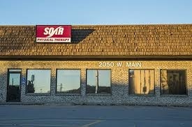
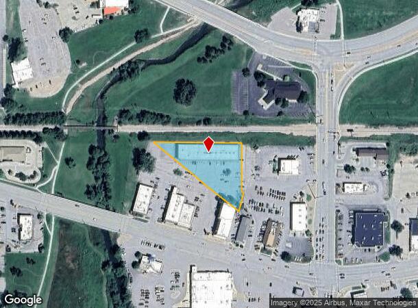
Property Record
2050 W Main St, Rapid City, SD 57702
NEARBY LISTINGS FOR SALE OR LEASE
Property Detail
2050 W Main St
Rapid City, SD
Rcld Add
0045103
RCLD ADD, LOT B, REVISED OF LOT 2 OF TRACT C (ALSOIN 1N-07E SEC 03)
Stripcommercialcenter
Pennington
AE
South Dakota
46103C0759H
2b
2024
1.18 AC
2025
Rapid City
011001
Other Market Areas
14,939 SF
DEMOGRAPHICS near 2050 W Main St
1 Mile
3 Mile
5 Mile
2024 Total Population
3,659
51,251
79,325
2029 Population
4,059
56,943
88,415
Pop Growth 2024-2029
+ 10.93%
+ 11.11%
+ 11.46%
Average Age
44
41
41
2024 Total Households
1,716
21,964
33,569
HH Growth 2024-2029
+ 11.25%
+ 11.52%
+ 11.83%
Median Household Inc
$64,396
$52,686
$60,689
Avg Household Size
2.00
2.10
2.20
2024 Avg HH Vehicles
2.00
2.00
2.00
Median Home Value
$275,650
$235,947
$257,493
Median Year Built
1969
1972
1979
Nearby Places
Map Layers
Map Styles
 Street
 Aerial
- Restaurants
- Banks
- Shops
- Fitness
- Groceries
PUBLIC TRANSPORTATION
AIRPORT
Rapid City Regional
DRIVE
WALK
Distance
Rapid City Regional
22 min
11.9 mi
Freight Ports
Tulsa Port Of Catoosa
DRIVE
WALK
Distance
Tulsa Port Of Catoosa
970 min
891.3 mi
SALE & LEASE HISTORY
LISTING DATE
SALE/LEASE

Nov 29, 2016
For Lease
Feb 25, 2019
For Lease
Nearby Properties
Address
Land Use
TOTAL SIZE
Lot Size
Zoning
Address
Land Use
TOTAL SIZE
Lot Size
Zoning
5,244 SF
17.53 AC
Address
Land Use
TOTAL SIZE
Lot Size
Zoning
40,853 SF
8.09 AC
Address
Land Use
TOTAL SIZE
Lot Size
Zoning
19,728 SF
7.67 AC
Address
Land Use
TOTAL SIZE
Lot Size
Zoning
6,480 SF
11.58 AC
Address
Land Use
TOTAL SIZE
Lot Size
Zoning
48,204 SF
15.19 AC
Address
Land Use
TOTAL SIZE
Lot Size
Zoning
6,820 SF
10.60 AC
Address
Land Use
TOTAL SIZE
Lot Size
Zoning
48,108 SF
38.14 AC
Address
Land Use
TOTAL SIZE
Lot Size
Zoning
26,807 SF
0.58 AC
Address
Land Use
TOTAL SIZE
Lot Size
Zoning
7,680 SF
9.34 AC
Address
Land Use
TOTAL SIZE
Lot Size
Zoning
29,226 SF
1.38 AC
Address
Land Use
TOTAL SIZE
Lot Size
Zoning
14,360 SF
2.07 AC
Address
Land Use
TOTAL SIZE
Lot Size
Zoning
25,762 SF
5.74 AC
Address
Land Use
TOTAL SIZE
Lot Size
Zoning
62,209 SF
14.15 AC
Address
Land Use
TOTAL SIZE
Lot Size
Zoning
10,608 SF
10.90 AC
Address
Land Use
TOTAL SIZE
Lot Size
Zoning
50,656 SF
9.17 AC
Address
Land Use
TOTAL SIZE
Lot Size
Zoning
46,025 SF
36.26 AC
Address
Land Use
TOTAL SIZE
Lot Size
Zoning
4,576 SF
4.85 AC
Address
Land Use
TOTAL SIZE
Lot Size
Zoning
26,845 SF
3.49 AC
Address
Land Use
TOTAL SIZE
Lot Size
Zoning
227,112 SF
21.01 AC
Address
Land Use
TOTAL SIZE
Lot Size
Zoning
35,999 SF
3.01 AC
Address
Land Use
TOTAL SIZE
Lot Size
Zoning
105,621 SF
10 AC
Address
Land Use
TOTAL SIZE
Lot Size
Zoning
5,448 SF
7.92 AC
Address
Land Use
TOTAL SIZE
Lot Size
Zoning
3,008 SF
4.66 AC
Address
Land Use
TOTAL SIZE
Lot Size
Zoning
30,740 SF
3.22 AC
Address
Land Use
TOTAL SIZE
Lot Size
Zoning
95,992 SF
56.73 AC
Address
Land Use
TOTAL SIZE
Lot Size
Zoning
19,671 SF
6.91 AC
Address
Land Use
TOTAL SIZE
Lot Size
Zoning
23,089 SF
0.30 AC
Address
Land Use
TOTAL SIZE
Lot Size
Zoning
48,786 SF
5 AC
Address
Land Use
TOTAL SIZE
Lot Size
Zoning
19,170 SF
1.28 AC
Address
Land Use
TOTAL SIZE
Lot Size
Zoning
9,395 SF
3.26 AC
The World's #1 Commercial Real Estate Marketplace
Connect with us
© 2025 CoStar Group
The information above has been obtained from sources believed reliable. While we do not doubt its accuracy we have not verified it and make no guarantee, warranty or representation about it. It is your responsibility to independently confirm its accuracy and completeness. Any projections, opinions, assumptions, or estimates used are for example only and do not represent the current or future performance of the property. The value of this transaction to you depends on tax and other factors which should be evaluated by your tax, financial, and legal advisors. You and your advisors should conduct a careful, independent investigation of the property to determine to your satisfaction the suitability of the property for your needs.