Property Record
20504 S St Rt 99 West Frontage Rd, Manteca, CA 95366
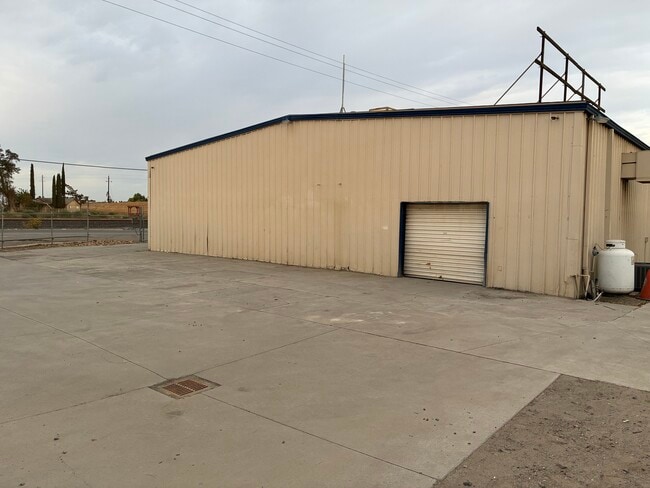

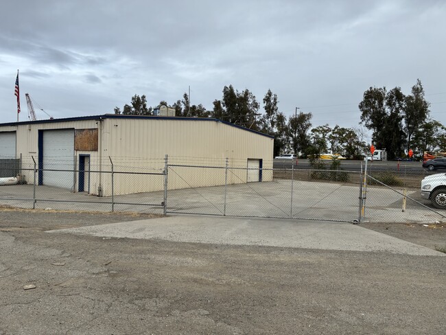

Property Detail
20504 S St Rt 99 West Frontage Rd
228-060-17
REDRAWN JAN-03-2002 FROM ORIGINAL APN 243-230-35
Lightindustrial
SAN JOAQUIN
CG
California
B and X Area of moderate flood hazard, usually the area between the limits of the 100-year and 500-year floods.
2.40 AC
2025
S Outlying San Joaquin Cty
2025
Stockton/Modesto
005004
Stockton-Lodi, CA
9,600 SF
NEARBY LISTINGS FOR SALE OR LEASE
DEMOGRAPHICS near 20504 S St Rt 99 West Frontage Rd
1 mile
3 mile
5 mile
2025 Total Population
2,884
41,804
109,428
2030 Population
3,092
44,101
115,081
Pop Growth 2025-2030
+ 7.21%
+ 5.49%
+ 5.17%
Average Age
36
38
38
2025 Total Households
835
13,351
35,040
HH Growth 2025-2030
+ 7.19%
+ 5.46%
+ 5.17%
Median Household Inc
$138,736
$97,562
$96,676
Avg Household Size
3.50
3.10
3.10
2025 Avg HH Vehicles
3.00
2.00
2.00
Median Home Value
$724,209
$650,701
$656,430
Median Year Built
2011
2000
1992
Nearby Places
Map Layers
Map Styles
 Street
 Aerial
Transit
 Traffic
 Biking
Places
Listings with unknown addresses are not visible on the map
- Restaurants
- Banks
- Shops
- Fitness
- Groceries
PUBLIC TRANSPORTATION
COMMUTER RAIL
Drive
Walk
Distance
13 min
5.7 mi
AIRPORT
Stockton Metro
Drive
Walk
Distance
Stockton Metro
21 min
11.9 mi
Freight Ports
Port of Stockton
Drive
Walk
Distance
Port of Stockton
29 min
20.3 mi
SALE & LEASE HISTORY
LISTING DATE
SALE/LEASE

Sep 29, 2025
For Lease
Nearby Properties
Address
Land Use
TOTAL SIZE
Lot Size
Zoning
Address
Land Use
TOTAL SIZE
Lot Size
Zoning
26,118 SF
10.80 AC
Address
Land Use
TOTAL SIZE
Lot Size
Zoning
552,450 SF
27.84 AC
Address
Land Use
TOTAL SIZE
Lot Size
Zoning
21,924 SF
9.27 AC
Address
Land Use
TOTAL SIZE
Lot Size
Zoning
350,415 SF
17.45 AC
Address
Land Use
TOTAL SIZE
Lot Size
Zoning
8,840 SF
7.51 AC
Address
Land Use
TOTAL SIZE
Lot Size
Zoning
286,072 SF
19.41 AC
Address
Land Use
TOTAL SIZE
Lot Size
Zoning
106,576 SF
6.85 AC
Address
Land Use
TOTAL SIZE
Lot Size
Zoning
608,500 SF
31.59 AC
Address
Land Use
TOTAL SIZE
Lot Size
Zoning
175,025 SF
9.06 AC
Address
Land Use
TOTAL SIZE
Lot Size
Zoning
7.89 AC
Address
Land Use
TOTAL SIZE
Lot Size
Zoning
66.42 AC
AU20
Address
Land Use
TOTAL SIZE
Lot Size
Zoning
116,872 SF
8.12 AC
Address
Land Use
TOTAL SIZE
Lot Size
Zoning
7,590 SF
3.51 AC
Address
Land Use
TOTAL SIZE
Lot Size
Zoning
16,000 SF
2 AC
Address
Land Use
TOTAL SIZE
Lot Size
Zoning
85,933 SF
3.32 AC
Address
Land Use
TOTAL SIZE
Lot Size
Zoning
2.98 AC
Address
Land Use
TOTAL SIZE
Lot Size
Zoning
37,020 SF
1.95 AC
Address
Land Use
TOTAL SIZE
Lot Size
Zoning
45,967 SF
26.19 AC
Address
Land Use
TOTAL SIZE
Lot Size
Zoning
129,117 SF
11.36 AC
Address
Land Use
TOTAL SIZE
Lot Size
Zoning
266,780 SF
14.24 AC
Address
Land Use
TOTAL SIZE
Lot Size
Zoning
108,000 SF
12.30 AC
Address
Land Use
TOTAL SIZE
Lot Size
Zoning
29.95 AC
Address
Land Use
TOTAL SIZE
Lot Size
Zoning
125,381 SF
11.75 AC
Address
Land Use
TOTAL SIZE
Lot Size
Zoning
1,026 SF
36.52 AC
Address
Land Use
TOTAL SIZE
Lot Size
Zoning
5,500 SF
5.47 AC
Address
Land Use
TOTAL SIZE
Lot Size
Zoning
3.03 AC
Address
Land Use
TOTAL SIZE
Lot Size
Zoning
42,371 SF
4.23 AC
Address
Land Use
TOTAL SIZE
Lot Size
Zoning
32.37 AC
Address
Land Use
TOTAL SIZE
Lot Size
Zoning
8.27 AC
Address
Land Use
TOTAL SIZE
Lot Size
Zoning
253,650 SF
13.54 AC
The World's #1 Commercial Real Estate Marketplace
Connect with us
© 2026 CoStar Group
The information above has been obtained from sources believed reliable. While we do not doubt its accuracy we have not verified it and make no guarantee, warranty or representation about it. It is your responsibility to independently confirm its accuracy and completeness. Any projections, opinions, assumptions, or estimates used are for example only and do not represent the current or future performance of the property. The value of this transaction to you depends on tax and other factors which should be evaluated by your tax, financial, and legal advisors. You and your advisors should conduct a careful, independent investigation of the property to determine to your satisfaction the suitability of the property for your needs.