Property Record
2051 E 5Th St, Winston Salem, NC 27101
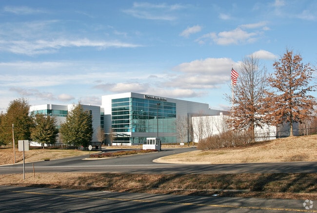

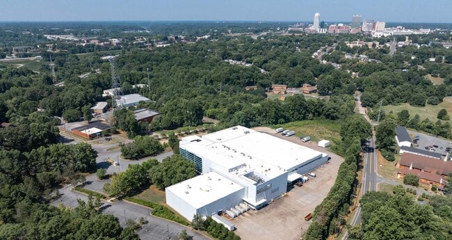
Property Detail
2051 E 5Th St
6845-07-8352
WINSTON-SALEM JOURNAL LO:019A BL:2440 BU:1
Lightindustrial
FORSYTH
LI
North Carolina
AE The base floodplain where base flood elevations are provided. AE Zones are now used on new format FIRMs instead of A1-A30 Zones.
19a
2023
11.23 AC
2025
NE Forsyth County
001700
Greensboro/Winston-Salem
125,130 SF
Winston-Salem, NC
NEARBY LISTINGS FOR SALE OR LEASE
DEMOGRAPHICS near 2051 E 5Th St
1 mile
3 mile
5 mile
2025 Total Population
6,247
63,347
144,944
2030 Population
6,564
66,125
150,696
Pop Growth 2025-2030
+ 5.07%
+ 4.39%
+ 3.97%
Average Age
39
37
37
2025 Total Households
2,693
25,597
57,470
HH Growth 2025-2030
+ 5.35%
+ 4.75%
+ 4.33%
Median Household Inc
$30,867
$41,883
$53,894
Avg Household Size
2.20
2.20
2.30
2025 Avg HH Vehicles
1.00
1.00
2.00
Median Home Value
$143,373
$181,804
$229,430
Median Year Built
1971
1968
1972
Nearby Places
Map Layers
Map Styles
 Street
 Aerial
Layers
 Traffic
 Biking
Places
Listings with unknown addresses are not visible on the map
- Restaurants
- Banks
- Shops
- Fitness
- Groceries
PUBLIC TRANSPORTATION
AIRPORT
Piedmont Triad International
Drive
Walk
Distance
Piedmont Triad International
31 min
19.2 mi
Freight Ports
Virginia Port Authority - Richmond
Drive
Walk
Distance
Virginia Port Authority - Richmond
258 min
222.9 mi
SALE & LEASE HISTORY
LISTING DATE
SALE/LEASE

Oct 22, 2024
For Sale
Nearby Properties
Address
Land Use
TOTAL SIZE
Lot Size
Zoning
Address
Land Use
TOTAL SIZE
Lot Size
Zoning
368,715 SF
4.11 AC
CI
Address
Land Use
TOTAL SIZE
Lot Size
Zoning
205,729 SF
2.35 AC
CI
Address
Land Use
TOTAL SIZE
Lot Size
Zoning
244,516 SF
4.42 AC
CI
Address
Land Use
TOTAL SIZE
Lot Size
Zoning
297,475 SF
3.06 AC
CI-S
Address
Land Use
TOTAL SIZE
Lot Size
Zoning
315,590 SF
2 AC
CB
Address
Land Use
TOTAL SIZE
Lot Size
Zoning
156,507 SF
NULL
Address
Land Use
TOTAL SIZE
Lot Size
Zoning
121,886 SF
3.92 AC
PB-S
Address
Land Use
TOTAL SIZE
Lot Size
Zoning
100 SF
37.41 AC
C,H
Address
Land Use
TOTAL SIZE
Lot Size
Zoning
202,752 SF
3.43 AC
PB-L
Address
Land Use
TOTAL SIZE
Lot Size
Zoning
352,549 SF
2.30 AC
CB WO
Address
Land Use
TOTAL SIZE
Lot Size
Zoning
140,472 SF
1.33 AC
CB WO
Address
Land Use
TOTAL SIZE
Lot Size
Zoning
153,315 SF
2.07 AC
CI
Address
Land Use
TOTAL SIZE
Lot Size
Zoning
195,551 SF
2.07 AC
CI
Address
Land Use
TOTAL SIZE
Lot Size
Zoning
200 SF
8.16 AC
PB-S
Address
Land Use
TOTAL SIZE
Lot Size
Zoning
154,655 SF
0.76 AC
CI
Address
Land Use
TOTAL SIZE
Lot Size
Zoning
112,000 SF
15.57 AC
IP
Address
Land Use
TOTAL SIZE
Lot Size
Zoning
205,979 SF
1.73 AC
CB WO
Address
Land Use
TOTAL SIZE
Lot Size
Zoning
207,203 SF
4.26 AC
PB
Address
Land Use
TOTAL SIZE
Lot Size
Zoning
70,376 SF
2.86 AC
PB-S
Address
Land Use
TOTAL SIZE
Lot Size
Zoning
106,204 SF
1.13 AC
CI
Address
Land Use
TOTAL SIZE
Lot Size
Zoning
124,134 SF
2.14 AC
CB WO
Address
Land Use
TOTAL SIZE
Lot Size
Zoning
121,925 SF
1.49 AC
GO
Address
Land Use
TOTAL SIZE
Lot Size
Zoning
200,188 SF
4.99 AC
GB-S
Address
Land Use
TOTAL SIZE
Lot Size
Zoning
115,340 SF
2.10 AC
CI
Address
Land Use
TOTAL SIZE
Lot Size
Zoning
185,506 SF
57.30 AC
GB
Address
Land Use
TOTAL SIZE
Lot Size
Zoning
56,975 SF
0.26 AC
CB WO
Address
Land Use
TOTAL SIZE
Lot Size
Zoning
62,714 SF
0.55 AC
CB WO
Address
Land Use
TOTAL SIZE
Lot Size
Zoning
177,562 SF
12.59 AC
GO
Address
Land Use
TOTAL SIZE
Lot Size
Zoning
100 SF
119.35 AC
C
Address
Land Use
TOTAL SIZE
Lot Size
Zoning
196,804 SF
2.16 AC
CB
The World's #1 Commercial Real Estate Marketplace
Connect with us
© 2026 CoStar Group
The information above has been obtained from sources believed reliable. While we do not doubt its accuracy we have not verified it and make no guarantee, warranty or representation about it. It is your responsibility to independently confirm its accuracy and completeness. Any projections, opinions, assumptions, or estimates used are for example only and do not represent the current or future performance of the property. The value of this transaction to you depends on tax and other factors which should be evaluated by your tax, financial, and legal advisors. You and your advisors should conduct a careful, independent investigation of the property to determine to your satisfaction the suitability of the property for your needs.