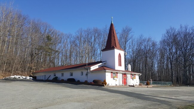
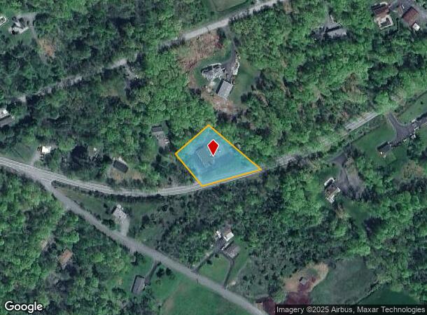
Property Record
2051 Route 6, Middletown, NY 10940
NEARBY LISTINGS FOR SALE OR LEASE
Property Detail
2051 Route 6
335600-022-000-0001-015.000-0000
Orange
Commercialnec
New York
X
15.00
36071C0245E
1.10 AC
2024
Middletown
2024
Northern New Jersey
015100
New York-Jersey City-White Plains, NY-NJ
2,144 SF
DEMOGRAPHICS near 2051 Route 6
1 Mile
3 Mile
5 Mile
2024 Total Population
902
5,979
14,720
2029 Population
910
6,056
14,911
Pop Growth 2024-2029
+ 0.89%
+ 1.29%
+ 1.30%
Average Age
40
40
40
2024 Total Households
311
1,994
4,993
HH Growth 2024-2029
+ 0.96%
+ 1.30%
+ 1.34%
Median Household Inc
$133,571
$127,005
$116,924
Avg Household Size
2.90
2.90
2.90
2024 Avg HH Vehicles
2.00
2.00
2.00
Median Home Value
$338,000
$366,012
$356,212
Median Year Built
1980
1984
1982
Nearby Places
- Restaurants
- Banks
- Shops
- Fitness
- Groceries
PUBLIC TRANSPORTATION
COMMUTER RAIL
Otisville (Bergen County/Port Jervis Line - NJ Transit Commuter Rail (NJ Transit), Main/Port Jervis Line - NJ Transit Commuter Rail (NJ Transit))
DRIVE
WALK
Distance
Otisville (Bergen County/Port Jervis Line - NJ Transit Commuter Rail (NJ Transit), Main/Port Jervis Line - NJ Transit Commuter Rail (NJ Transit))
21 min
9.0 mi
AIRPORT
New York Stewart International
DRIVE
WALK
Distance
New York Stewart International
39 min
28.4 mi
Freight Ports
Port Newark Container Terminal
DRIVE
WALK
Distance
Port Newark Container Terminal
102 min
77.0 mi
SALE & LEASE HISTORY
LISTING DATE
SALE/LEASE

Apr 02, 2018
For Sale
Nearby Properties
Address
Land Use
TOTAL SIZE
Lot Size
Zoning
Address
Land Use
TOTAL SIZE
Lot Size
Zoning
129.70 AC
AR
Address
Land Use
TOTAL SIZE
Lot Size
Zoning
2,576 SF
146.70 AC
AR
Address
Land Use
TOTAL SIZE
Lot Size
Zoning
Address
Land Use
TOTAL SIZE
Lot Size
Zoning
62.90 AC
AR
Address
Land Use
TOTAL SIZE
Lot Size
Zoning
25,357 SF
13.40 AC
AR
Address
Land Use
TOTAL SIZE
Lot Size
Zoning
18,180 SF
209.70 AC
BT
Address
Land Use
TOTAL SIZE
Lot Size
Zoning
0.23 AC
Address
Land Use
TOTAL SIZE
Lot Size
Zoning
23.60 AC
AR
Address
Land Use
TOTAL SIZE
Lot Size
Zoning
44.30 AC
AR
Address
Land Use
TOTAL SIZE
Lot Size
Zoning
7,922 SF
162.90 AC
AR
Address
Land Use
TOTAL SIZE
Lot Size
Zoning
105.80 AC
SR
Address
Land Use
TOTAL SIZE
Lot Size
Zoning
70.10 AC
AR
Address
Land Use
TOTAL SIZE
Lot Size
Zoning
7,242 SF
133.30 AC
TC2
Address
Land Use
TOTAL SIZE
Lot Size
Zoning
43.80 AC
AR
Address
Land Use
TOTAL SIZE
Lot Size
Zoning
19.40 AC
AR
Address
Land Use
TOTAL SIZE
Lot Size
Zoning
9,752 SF
64.30 AC
TC2
Address
Land Use
TOTAL SIZE
Lot Size
Zoning
1,632 SF
91 AC
AR
Address
Land Use
TOTAL SIZE
Lot Size
Zoning
6,576 SF
5.30 AC
TC2
Address
Land Use
TOTAL SIZE
Lot Size
Zoning
16.80 AC
AR
Address
Land Use
TOTAL SIZE
Lot Size
Zoning
6,196 SF
24.50 AC
BT
Address
Land Use
TOTAL SIZE
Lot Size
Zoning
54.40 AC
BT
Address
Land Use
TOTAL SIZE
Lot Size
Zoning
34 AC
TC2
Address
Land Use
TOTAL SIZE
Lot Size
Zoning
2,002 SF
74.60 AC
AR
Address
Land Use
TOTAL SIZE
Lot Size
Zoning
4,960 SF
74 AC
AR
Address
Land Use
TOTAL SIZE
Lot Size
Zoning
3,264 SF
101.50 AC
AR
Address
Land Use
TOTAL SIZE
Lot Size
Zoning
624 SF
51.10 AC
AR
Address
Land Use
TOTAL SIZE
Lot Size
Zoning
2,108 SF
32.70 AC
AR
Address
Land Use
TOTAL SIZE
Lot Size
Zoning
5,246 SF
39.90 AC
BT
Address
Land Use
TOTAL SIZE
Lot Size
Zoning
2,972 SF
1.10 AC
TC2
Address
Land Use
TOTAL SIZE
Lot Size
Zoning
4,748 SF
24.30 AC
AR
The World's #1 Commercial Real Estate Marketplace
Connect with us
© 2025 CoStar Group
The information above has been obtained from sources believed reliable. While we do not doubt its accuracy we have not verified it and make no guarantee, warranty or representation about it. It is your responsibility to independently confirm its accuracy and completeness. Any projections, opinions, assumptions, or estimates used are for example only and do not represent the current or future performance of the property. The value of this transaction to you depends on tax and other factors which should be evaluated by your tax, financial, and legal advisors. You and your advisors should conduct a careful, independent investigation of the property to determine to your satisfaction the suitability of the property for your needs.