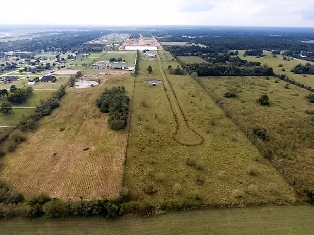
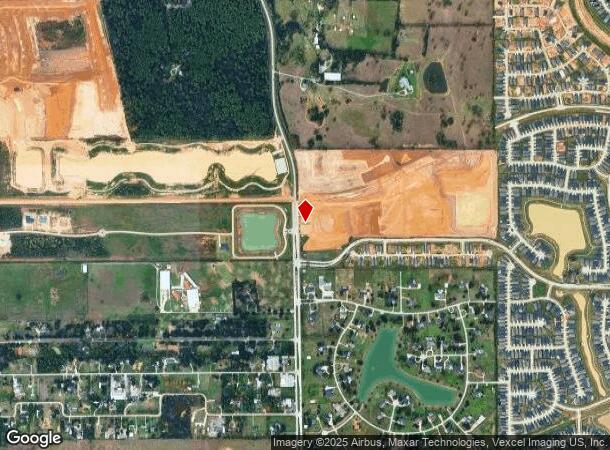
Property Record
20510 Mueschke Rd, Tomball, TX 77377


NEARBY LISTINGS FOR SALE OR LEASE
Property Detail
20510 Mueschke Rd
Houston-The Woodlands-Sugar Land, TX
Abst 240 G Dedrick
0421010000115
TR 6B (PURE ACCT*0421010000150) ABST 240 G DEDRICK
Vacantlandnec
Harris
X
Texas
48339C0675G
11.02 AC
2023
Northwest Outlier
2025
Houston
555600
DEMOGRAPHICS near 20510 Mueschke Rd
1 Mile
3 Mile
5 Mile
2024 Total Population
834
10,487
54,084
2029 Population
852
10,866
56,902
Pop Growth 2024-2029
+ 2.16%
+ 3.61%
+ 5.21%
Average Age
39
38
36
2024 Total Households
266
3,344
16,994
HH Growth 2024-2029
+ 2.26%
+ 3.65%
+ 5.36%
Median Household Inc
$127,778
$114,449
$105,526
Avg Household Size
3.20
3.10
3.10
2024 Avg HH Vehicles
3.00
2.00
2.00
Median Home Value
$554,687
$421,233
$304,512
Median Year Built
2003
2003
2005
Nearby Places
Map Layers
Map Styles
 Street
 Aerial
- Restaurants
- Banks
- Shops
- Fitness
- Groceries
PUBLIC TRANSPORTATION
AIRPORT
George Bush Intcntl/Houston
DRIVE
WALK
Distance
George Bush Intcntl/Houston
41 min
32.2 mi
Freight Ports
Port of Houston
DRIVE
WALK
Distance
Port of Houston
61 min
42.9 mi
SALE & LEASE HISTORY
LISTING DATE
SALE/LEASE

Mar 06, 2018
For Sale
Jan 24, 2018
For Sale
Aug 03, 2017
For Sale
Nearby Properties
Address
Land Use
TOTAL SIZE
Lot Size
Zoning
Address
Land Use
TOTAL SIZE
Lot Size
Zoning
326,902 SF
15.45 AC
Address
Land Use
TOTAL SIZE
Lot Size
Zoning
280.90 AC
Address
Land Use
TOTAL SIZE
Lot Size
Zoning
123,400 SF
15.08 AC
Address
Land Use
TOTAL SIZE
Lot Size
Zoning
55,800 SF
25.95 AC
Address
Land Use
TOTAL SIZE
Lot Size
Zoning
238.57 AC
Address
Land Use
TOTAL SIZE
Lot Size
Zoning
210.95 AC
Address
Land Use
TOTAL SIZE
Lot Size
Zoning
27,542 SF
4.44 AC
Address
Land Use
TOTAL SIZE
Lot Size
Zoning
74,400 SF
6.43 AC
Address
Land Use
TOTAL SIZE
Lot Size
Zoning
56,396 SF
29.96 AC
Address
Land Use
TOTAL SIZE
Lot Size
Zoning
57,059 SF
83.47 AC
Address
Land Use
TOTAL SIZE
Lot Size
Zoning
157.95 AC
Address
Land Use
TOTAL SIZE
Lot Size
Zoning
62,322 SF
15.82 AC
Address
Land Use
TOTAL SIZE
Lot Size
Zoning
39,320 SF
6.46 AC
Address
Land Use
TOTAL SIZE
Lot Size
Zoning
83,930 SF
4.74 AC
Address
Land Use
TOTAL SIZE
Lot Size
Zoning
76.78 AC
Address
Land Use
TOTAL SIZE
Lot Size
Zoning
113,545 SF
8.24 AC
Address
Land Use
TOTAL SIZE
Lot Size
Zoning
Address
Land Use
TOTAL SIZE
Lot Size
Zoning
85,700 SF
6 AC
Address
Land Use
TOTAL SIZE
Lot Size
Zoning
6,729 SF
98.17 AC
Address
Land Use
TOTAL SIZE
Lot Size
Zoning
24,324 SF
2.29 AC
Address
Land Use
TOTAL SIZE
Lot Size
Zoning
924 SF
96.75 AC
Address
Land Use
TOTAL SIZE
Lot Size
Zoning
81.64 AC
Address
Land Use
TOTAL SIZE
Lot Size
Zoning
94.79 AC
Address
Land Use
TOTAL SIZE
Lot Size
Zoning
Address
Land Use
TOTAL SIZE
Lot Size
Zoning
20,581 SF
14.85 AC
Address
Land Use
TOTAL SIZE
Lot Size
Zoning
3,428 SF
12.76 AC
Address
Land Use
TOTAL SIZE
Lot Size
Zoning
113.94 AC
Address
Land Use
TOTAL SIZE
Lot Size
Zoning
48.33 AC
Address
Land Use
TOTAL SIZE
Lot Size
Zoning
52.94 AC
Address
Land Use
TOTAL SIZE
Lot Size
Zoning
22.95 AC
The World's #1 Commercial Real Estate Marketplace
Connect with us
© 2025 CoStar Group
The information above has been obtained from sources believed reliable. While we do not doubt its accuracy we have not verified it and make no guarantee, warranty or representation about it. It is your responsibility to independently confirm its accuracy and completeness. Any projections, opinions, assumptions, or estimates used are for example only and do not represent the current or future performance of the property. The value of this transaction to you depends on tax and other factors which should be evaluated by your tax, financial, and legal advisors. You and your advisors should conduct a careful, independent investigation of the property to determine to your satisfaction the suitability of the property for your needs.