Property Record
20512 Sw Roy Rogers Rd, Sherwood, OR 97140
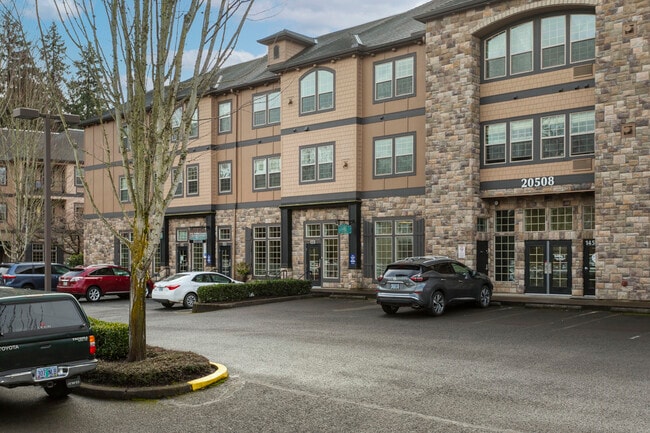
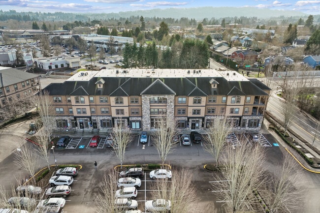
This Property Is For Sale
NEARBY LISTINGS FOR SALE OR LEASE
Property Detail
20512 Sw Roy Rogers Rd
Portland-Vancouver-Hillsboro, OR-WA
Hunters Ridge Condo
R2145269
Washington
Condominium
Oregon
X
131 SF
41067C0601F
Sherwood/Tualatin North
834 SF
Portland
DEMOGRAPHICS near 20512 Sw Roy Rogers Rd
1 Mile
3 Mile
5 Mile
2024 Total Population
7,653
38,619
123,482
2029 Population
7,746
38,777
124,030
Pop Growth 2024-2029
+ 1.22%
+ 0.41%
+ 0.44%
Average Age
38
40
40
2024 Total Households
2,659
13,943
47,341
HH Growth 2024-2029
+ 1.32%
+ 0.49%
+ 0.46%
Median Household Inc
$94,185
$104,638
$102,686
Avg Household Size
2.80
2.70
2.60
2024 Avg HH Vehicles
2.00
2.00
2.00
Median Home Value
$486,836
$539,392
$556,176
Median Year Built
1999
1996
1993
Nearby Places
Map Layers
Map Styles
 Street
 Aerial
- Restaurants
- Banks
- Shops
- Fitness
- Groceries
PUBLIC TRANSPORTATION
COMMUTER RAIL
Tualatin (Westside Express Service - Tri-County Metropolitan Transportation District of Oregon Rail (TriMet Rail))
DRIVE
WALK
Distance
Tualatin (Westside Express Service - Tri-County Metropolitan Transportation District of Oregon Rail (TriMet Rail))
9 min
4.6 mi
Wilsonville (Westside Express Service - Tri-County Metropolitan Transportation District of Oregon Rail (TriMet Rail))
DRIVE
WALK
Distance
Wilsonville (Westside Express Service - Tri-County Metropolitan Transportation District of Oregon Rail (TriMet Rail))
16 min
8.1 mi
AIRPORT
Portland International
DRIVE
WALK
Distance
Portland International
45 min
26.9 mi
Freight Ports
Port of Portland
DRIVE
WALK
Distance
Port of Portland
31 min
18.1 mi
Nearby Properties
Address
Land Use
TOTAL SIZE
Lot Size
Zoning
Address
Land Use
TOTAL SIZE
Lot Size
Zoning
23.98 AC
EI
Address
Land Use
TOTAL SIZE
Lot Size
Zoning
353,000 SF
69.95 AC
IP
Address
Land Use
TOTAL SIZE
Lot Size
Zoning
27.23 AC
MP
Address
Land Use
TOTAL SIZE
Lot Size
Zoning
27.85 AC
IP
Address
Land Use
TOTAL SIZE
Lot Size
Zoning
9.12 AC
R-7
Address
Land Use
TOTAL SIZE
Lot Size
Zoning
1,232 SF
27.77 AC
EI
Address
Land Use
TOTAL SIZE
Lot Size
Zoning
18.06 AC
Address
Land Use
TOTAL SIZE
Lot Size
Zoning
127,476 SF
13.48 AC
RC
Address
Land Use
TOTAL SIZE
Lot Size
Zoning
139,356 SF
13.99 AC
LI_PUD
Address
Land Use
TOTAL SIZE
Lot Size
Zoning
15,000 SF
21.08 AC
MG
Address
Land Use
TOTAL SIZE
Lot Size
Zoning
22.05 AC
MP
Address
Land Use
TOTAL SIZE
Lot Size
Zoning
168,065 SF
5.09 AC
HDR_PUD
Address
Land Use
TOTAL SIZE
Lot Size
Zoning
225,780 SF
10.01 AC
R-24
Address
Land Use
TOTAL SIZE
Lot Size
Zoning
261,104 SF
13.52 AC
HDR_PUD
Address
Land Use
TOTAL SIZE
Lot Size
Zoning
13.76 AC
RMH
Address
Land Use
TOTAL SIZE
Lot Size
Zoning
220,472 SF
8.99 AC
RH
Address
Land Use
TOTAL SIZE
Lot Size
Zoning
1,360 SF
7.41 AC
HDR
Address
Land Use
TOTAL SIZE
Lot Size
Zoning
124,718 SF
10.89 AC
RC_PUD
Address
Land Use
TOTAL SIZE
Lot Size
Zoning
145,000 SF
4.01 AC
RC
Address
Land Use
TOTAL SIZE
Lot Size
Zoning
226,960 SF
11.38 AC
MG
Address
Land Use
TOTAL SIZE
Lot Size
Zoning
13 AC
MP
Address
Land Use
TOTAL SIZE
Lot Size
Zoning
5.35 AC
ML
Address
Land Use
TOTAL SIZE
Lot Size
Zoning
190,000 SF
24.86 AC
IP
Address
Land Use
TOTAL SIZE
Lot Size
Zoning
1,089 SF
8.97 AC
MG
Address
Land Use
TOTAL SIZE
Lot Size
Zoning
14.47 AC
R-24
Address
Land Use
TOTAL SIZE
Lot Size
Zoning
10.82 AC
RMH
Address
Land Use
TOTAL SIZE
Lot Size
Zoning
131,000 SF
13.90 AC
RL
Address
Land Use
TOTAL SIZE
Lot Size
Zoning
8.40 AC
The World's #1 Commercial Real Estate Marketplace
Connect with us
© 2026 CoStar Group
The information above has been obtained from sources believed reliable. While we do not doubt its accuracy we have not verified it and make no guarantee, warranty or representation about it. It is your responsibility to independently confirm its accuracy and completeness. Any projections, opinions, assumptions, or estimates used are for example only and do not represent the current or future performance of the property. The value of this transaction to you depends on tax and other factors which should be evaluated by your tax, financial, and legal advisors. You and your advisors should conduct a careful, independent investigation of the property to determine to your satisfaction the suitability of the property for your needs.