Property Record
2052 State Route 35, Wall Township, NJ 07719
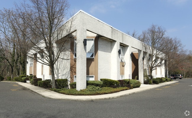

Property Detail
2052 State Route 35
52-00728-0000-00031
ALSO LOTS 2 & 3 NIT 1A
Officebuilding
MONMOUTH
HB80
New Jersey
AE The base floodplain where base flood elevations are provided. AE Zones are now used on new format FIRMs instead of A1-A30 Zones.
31
2024
1.15 AC
2025
Southern Monmouth
808800
Northern New Jersey
9,958 SF
Lakewood-New Brunswick, NJ
NEARBY LISTINGS FOR SALE OR LEASE
-
-
-
-
-
-
-
No Photo
-
View all Wall Township listings for lease on LoopNet.com
DEMOGRAPHICS near 2052 State Route 35
1 mile
3 mile
5 mile
2025 Total Population
6,253
55,147
130,323
2030 Population
6,419
56,597
133,239
Pop Growth 2025-2030
+ 2.65%
+ 2.63%
+ 2.24%
Average Age
49
46
44
2025 Total Households
2,718
23,048
53,810
HH Growth 2025-2030
+ 2.61%
+ 2.71%
+ 2.24%
Median Household Inc
$107,823
$130,298
$112,875
Avg Household Size
2.20
2.30
2.30
2025 Avg HH Vehicles
2.00
2.00
2.00
Median Home Value
$773,965
$817,819
$679,908
Median Year Built
1974
1969
1968
Nearby Places
Map Layers
Map Styles
 Street
 Aerial
Layers
 Traffic
 Biking
Places
Listings with unknown addresses are not visible on the map
- Restaurants
- Banks
- Shops
- Fitness
- Groceries
PUBLIC TRANSPORTATION
COMMUTER RAIL
Spring Lake (North Jersey Coast Line - NJ Transit Commuter Rail (NJ Transit))
Drive
Walk
Distance
Spring Lake (North Jersey Coast Line - NJ Transit Commuter Rail (NJ Transit))
5 min
1.8 mi
Manasquan (North Jersey Coast Line - NJ Transit Commuter Rail (NJ Transit))
Drive
Walk
Distance
Manasquan (North Jersey Coast Line - NJ Transit Commuter Rail (NJ Transit))
7 min
2.5 mi
Freight Ports
New York Container Terminal
Drive
Walk
Distance
New York Container Terminal
1 min
34.4 mi
SALE & LEASE HISTORY
LISTING DATE
SALE/LEASE

Aug 13, 2021
For Lease
Nearby Properties
Address
Land Use
TOTAL SIZE
Lot Size
Zoning
Address
Land Use
TOTAL SIZE
Lot Size
Zoning
22,660 SF
164.35 AC
4
Address
Land Use
TOTAL SIZE
Lot Size
Zoning
2,596 SF
54.13 AC
SF10
Address
Land Use
TOTAL SIZE
Lot Size
Zoning
1,846 SF
23.23 AC
SF10
Address
Land Use
TOTAL SIZE
Lot Size
Zoning
23,868 SF
137.35 AC
SF40
Address
Land Use
TOTAL SIZE
Lot Size
Zoning
4,078 SF
11.84 AC
SF05
Address
Land Use
TOTAL SIZE
Lot Size
Zoning
3.46 AC
SF05
Address
Land Use
TOTAL SIZE
Lot Size
Zoning
5,000 SF
22.50 AC
CONREC
Address
Land Use
TOTAL SIZE
Lot Size
Zoning
190,893 SF
36.69 AC
POS
Address
Land Use
TOTAL SIZE
Lot Size
Zoning
17.66 AC
1E
Address
Land Use
TOTAL SIZE
Lot Size
Zoning
35,639 SF
99.30 AC
SF20
Address
Land Use
TOTAL SIZE
Lot Size
Zoning
71,070 SF
11.81 AC
MLHB
Address
Land Use
TOTAL SIZE
Lot Size
Zoning
49,657 SF
11.22 AC
HB80
Address
Land Use
TOTAL SIZE
Lot Size
Zoning
20,959 SF
3.10 AC
SF10
Address
Land Use
TOTAL SIZE
Lot Size
Zoning
61,432 SF
3.44 AC
SF05
Address
Land Use
TOTAL SIZE
Lot Size
Zoning
7.79 AC
MLCC
Address
Land Use
TOTAL SIZE
Lot Size
Zoning
254,714 SF
3.40 AC
WPRA
Address
Land Use
TOTAL SIZE
Lot Size
Zoning
9.30 AC
SF05
Address
Land Use
TOTAL SIZE
Lot Size
Zoning
61,536 SF
3.44 AC
SF05
Address
Land Use
TOTAL SIZE
Lot Size
Zoning
84,297 SF
42.37 AC
CR40
Address
Land Use
TOTAL SIZE
Lot Size
Zoning
145,918 SF
20.31 AC
OR-5
Address
Land Use
TOTAL SIZE
Lot Size
Zoning
49,170 SF
8.38 AC
HB80
Address
Land Use
TOTAL SIZE
Lot Size
Zoning
45,236 SF
48.30 AC
POS
Address
Land Use
TOTAL SIZE
Lot Size
Zoning
27,328 SF
6.79 AC
HB12
Address
Land Use
TOTAL SIZE
Lot Size
Zoning
26.05 AC
SF10
Address
Land Use
TOTAL SIZE
Lot Size
Zoning
43,217 SF
0.86 AC
SF10
Address
Land Use
TOTAL SIZE
Lot Size
Zoning
86,051 SF
9.41 AC
HB12
Address
Land Use
TOTAL SIZE
Lot Size
Zoning
6.43 AC
SF05
Address
Land Use
TOTAL SIZE
Lot Size
Zoning
115,960 SF
17.93 AC
OR-5
Address
Land Use
TOTAL SIZE
Lot Size
Zoning
111,580 SF
25 AC
POS
Address
Land Use
TOTAL SIZE
Lot Size
Zoning
8.83 AC
R-2
The World's #1 Commercial Real Estate Marketplace
Connect with us
© 2026 CoStar Group
The information above has been obtained from sources believed reliable. While we do not doubt its accuracy we have not verified it and make no guarantee, warranty or representation about it. It is your responsibility to independently confirm its accuracy and completeness. Any projections, opinions, assumptions, or estimates used are for example only and do not represent the current or future performance of the property. The value of this transaction to you depends on tax and other factors which should be evaluated by your tax, financial, and legal advisors. You and your advisors should conduct a careful, independent investigation of the property to determine to your satisfaction the suitability of the property for your needs.