Property Record
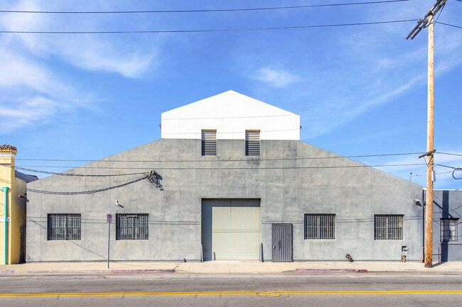
2049 E 38Th St, Vernon, CA 90058

NEARBY LISTINGS FOR SALE OR LEASE
Property Detail
2049 E 38Th St
Los Angeles-Long Beach-Glendale, CA
Aldine Square Tract
6302-012-013
CORRECTED MAP OF THE ALDINE SQUARE TRACT LOTS 49,50,51,52,53 AND LOT 54 BLK 1
Lightindustrial
Los Angeles
X
California
06037C1638G
49
2024
0.78 AC
2025
Vernon
980016
Los Angeles
38,271 SF
DEMOGRAPHICS near 2049 E 38Th St
1 Mile
3 Mile
5 Mile
2024 Total Population
17,550
351,687
1,158,432
2029 Population
16,341
335,796
1,112,132
Pop Growth 2024-2029
(6.89%)
(4.52%)
(4.00%)
Average Age
33
36
36
2024 Total Households
3,861
104,106
347,917
HH Growth 2024-2029
(7.64%)
(4.16%)
(3.85%)
Median Household Inc
$49,481
$49,098
$49,518
Avg Household Size
4.10
3.10
3.10
2024 Avg HH Vehicles
2.00
1.00
2.00
Median Home Value
$555,121
$611,302
$622,571
Median Year Built
1953
1956
1955
Nearby Places
Map Layers
Map Styles
 Street
 Aerial
- Restaurants
- Banks
- Shops
- Fitness
- Groceries
PUBLIC TRANSPORTATION
COMMUTER RAIL
DRIVE
WALK
Distance
8 min
3.5 mi
Union Station (91 Line - Southern California Regional Rail Authority (Metrolink), Antelope Valley Line - Southern California Regional Rail Authority (Metrolink), Orange County Line - Southern California Regional Rail Authority (Metrolink), Riverside Line - Southern California Regional Rail Authority (Metrolink), San Bernardino Line - Southern California Regional Rail Authority (Metrolink), Ventura County Line - Southern California Regional Rail Authority (Metrolink))
DRIVE
WALK
Distance
Union Station (91 Line - Southern California Regional Rail Authority (Metrolink), Antelope Valley Line - Southern California Regional Rail Authority (Metrolink), Orange County Line - Southern California Regional Rail Authority (Metrolink), Riverside Line - Southern California Regional Rail Authority (Metrolink), San Bernardino Line - Southern California Regional Rail Authority (Metrolink), Ventura County Line - Southern California Regional Rail Authority (Metrolink))
11 min
3.8 mi
AIRPORT
Los Angeles International
DRIVE
WALK
Distance
Los Angeles International
24 min
13.5 mi
Long Beach (Daugherty Field)
DRIVE
WALK
Distance
Long Beach (Daugherty Field)
29 min
16.2 mi
Bob Hope
DRIVE
WALK
Distance
Bob Hope
28 min
20.5 mi
Freight Ports
Port of Long Beach
DRIVE
WALK
Distance
Port of Long Beach
31 min
18.6 mi
SALE & LEASE HISTORY
LISTING DATE
SALE/LEASE

Mar 12, 2024
For Sale
Mar 07, 2017
For Lease
Mar 07, 2017
For Sale
Jul 07, 2025
For Sale
Jan 21, 2025
For Lease
Jan 07, 2025
For Sale
Apr 01, 2024
For Lease
Nearby Properties
Address
Land Use
TOTAL SIZE
Lot Size
Zoning
Address
Land Use
TOTAL SIZE
Lot Size
Zoning
969,516 SF
14.75 AC
Address
Land Use
TOTAL SIZE
Lot Size
Zoning
717,065 SF
0.99 AC
LAC2
Address
Land Use
TOTAL SIZE
Lot Size
Zoning
200,811 SF
4.59 AC
LALASED
Address
Land Use
TOTAL SIZE
Lot Size
Zoning
1,178,786 SF
3.89 AC
LAC2
Address
Land Use
TOTAL SIZE
Lot Size
Zoning
764,804 SF
1.48 AC
Address
Land Use
TOTAL SIZE
Lot Size
Zoning
634,863 SF
2.97 AC
LAC2-4D
Address
Land Use
TOTAL SIZE
Lot Size
Zoning
420,864 SF
63.07 AC
LAUSC-1A
Address
Land Use
TOTAL SIZE
Lot Size
Zoning
574,047 SF
1.70 AC
LAR5
Address
Land Use
TOTAL SIZE
Lot Size
Zoning
773,409 SF
1.39 AC
LAC4
Address
Land Use
TOTAL SIZE
Lot Size
Zoning
2,697,158 SF
20.18 AC
LAM2
Address
Land Use
TOTAL SIZE
Lot Size
Zoning
256,059 SF
Address
Land Use
TOTAL SIZE
Lot Size
Zoning
581,956 SF
0.89 AC
LAR5
Address
Land Use
TOTAL SIZE
Lot Size
Zoning
387,421 SF
1.08 AC
LAR5
Address
Land Use
TOTAL SIZE
Lot Size
Zoning
195,675 SF
LAC2
Address
Land Use
TOTAL SIZE
Lot Size
Zoning
377,377 SF
0.65 AC
LAC2
Address
Land Use
TOTAL SIZE
Lot Size
Zoning
364,997 SF
1.24 AC
LAR5
Address
Land Use
TOTAL SIZE
Lot Size
Zoning
50,048 SF
1.16 AC
LAR5
Address
Land Use
TOTAL SIZE
Lot Size
Zoning
666,499 SF
10.63 AC
LAC2
Address
Land Use
TOTAL SIZE
Lot Size
Zoning
298,630 SF
4.64 AC
LAUSC-1B
Address
Land Use
TOTAL SIZE
Lot Size
Zoning
461,090 SF
0.47 AC
LAC2
Address
Land Use
TOTAL SIZE
Lot Size
Zoning
329,487 SF
0.94 AC
LAC2
Address
Land Use
TOTAL SIZE
Lot Size
Zoning
466,058 SF
2.54 AC
Address
Land Use
TOTAL SIZE
Lot Size
Zoning
320,925 SF
0.88 AC
LAC2
Address
Land Use
TOTAL SIZE
Lot Size
Zoning
444,139 SF
3.63 AC
LAM3
Address
Land Use
TOTAL SIZE
Lot Size
Zoning
9.17 AC
LALASED
Address
Land Use
TOTAL SIZE
Lot Size
Zoning
448,914 SF
2.67 AC
LAC2
Address
Land Use
TOTAL SIZE
Lot Size
Zoning
311,717 SF
1.45 AC
LAR5
Address
Land Use
TOTAL SIZE
Lot Size
Zoning
274,675 SF
1.34 AC
LAR5
Address
Land Use
TOTAL SIZE
Lot Size
Zoning
479,272 SF
16.14 AC
LAM3
Address
Land Use
TOTAL SIZE
Lot Size
Zoning
1,027,870 SF
2.02 AC
LAC2
The World's #1 Commercial Real Estate Marketplace
Connect with us
© 2026 CoStar Group
The information above has been obtained from sources believed reliable. While we do not doubt its accuracy we have not verified it and make no guarantee, warranty or representation about it. It is your responsibility to independently confirm its accuracy and completeness. Any projections, opinions, assumptions, or estimates used are for example only and do not represent the current or future performance of the property. The value of this transaction to you depends on tax and other factors which should be evaluated by your tax, financial, and legal advisors. You and your advisors should conduct a careful, independent investigation of the property to determine to your satisfaction the suitability of the property for your needs.