Property Record
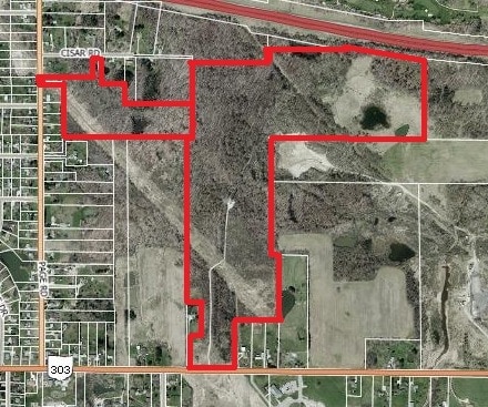
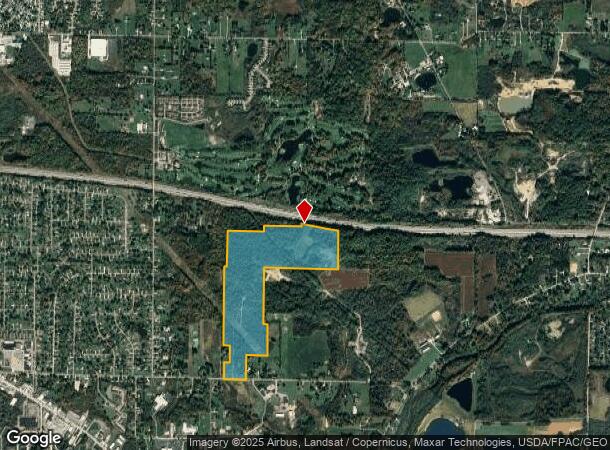
2053 State Route 303, Streetsboro, OH 44241
NEARBY LISTINGS FOR SALE OR LEASE
Property Detail
2053 State Route 303
Akron, OH
LOT 48 E & 38SE & 39SW & LOT 49SW
35-047-00-00-027-000
Portage
Agriculturalland
Ohio
2024
48,49
2024
108.20 AC
600401
Portage County
2,544 SF
Cleveland
DEMOGRAPHICS near 2053 State Route 303
1 Mile
3 Mile
5 Mile
2024 Total Population
2,036
19,082
36,325
2029 Population
2,056
19,494
36,856
Pop Growth 2024-2029
+ 0.98%
+ 2.16%
+ 1.46%
Average Age
43
41
42
2024 Total Households
818
8,127
14,630
HH Growth 2024-2029
+ 0.73%
+ 2.13%
+ 1.42%
Median Household Inc
$73,209
$71,931
$82,979
Avg Household Size
2.40
2.30
2.40
2024 Avg HH Vehicles
2.00
2.00
2.00
Median Home Value
$176,863
$182,090
$239,761
Median Year Built
1965
1989
1984
Nearby Places
Map Layers
Map Styles
 Street
 Aerial
- Restaurants
- Banks
- Shops
- Fitness
- Groceries
PUBLIC TRANSPORTATION
AIRPORT
Akron-Canton Regional
DRIVE
WALK
Distance
Akron-Canton Regional
55 min
42.4 mi
Cleveland-Hopkins International
DRIVE
WALK
Distance
Cleveland-Hopkins International
59 min
45.9 mi
Freight Ports
Port of Toledo
DRIVE
WALK
Distance
Port of Toledo
162 min
140.3 mi
SALE & LEASE HISTORY
LISTING DATE
SALE/LEASE

Sep 24, 2016
For Sale
May 30, 2017
For Sale
Nearby Properties
Address
Land Use
TOTAL SIZE
Lot Size
Zoning
Address
Land Use
TOTAL SIZE
Lot Size
Zoning
435,216 SF
31.88 AC
Address
Land Use
TOTAL SIZE
Lot Size
Zoning
117,571 SF
119.98 AC
Address
Land Use
TOTAL SIZE
Lot Size
Zoning
257,381 SF
28.99 AC
Address
Land Use
TOTAL SIZE
Lot Size
Zoning
441,158 SF
74.07 AC
Address
Land Use
TOTAL SIZE
Lot Size
Zoning
73,295 SF
12.75 AC
Address
Land Use
TOTAL SIZE
Lot Size
Zoning
129,487 SF
33.05 AC
Address
Land Use
TOTAL SIZE
Lot Size
Zoning
142,748 SF
10.11 AC
Address
Land Use
TOTAL SIZE
Lot Size
Zoning
206,907 SF
1.11 AC
Address
Land Use
TOTAL SIZE
Lot Size
Zoning
156,150 SF
14.68 AC
Address
Land Use
TOTAL SIZE
Lot Size
Zoning
84,587 SF
19.29 AC
Address
Land Use
TOTAL SIZE
Lot Size
Zoning
22,052 SF
12.52 AC
Address
Land Use
TOTAL SIZE
Lot Size
Zoning
170,490 SF
17.74 AC
Address
Land Use
TOTAL SIZE
Lot Size
Zoning
87,010 SF
22.96 AC
Address
Land Use
TOTAL SIZE
Lot Size
Zoning
251,864 SF
22.07 AC
Address
Land Use
TOTAL SIZE
Lot Size
Zoning
88,934 SF
19.65 AC
Address
Land Use
TOTAL SIZE
Lot Size
Zoning
142,832 SF
20.95 AC
Address
Land Use
TOTAL SIZE
Lot Size
Zoning
194,632 SF
19.41 AC
Address
Land Use
TOTAL SIZE
Lot Size
Zoning
150,755 SF
15.98 AC
Address
Land Use
TOTAL SIZE
Lot Size
Zoning
264,090 SF
17.44 AC
Address
Land Use
TOTAL SIZE
Lot Size
Zoning
230,256 SF
20 AC
Address
Land Use
TOTAL SIZE
Lot Size
Zoning
197,800 SF
10.06 AC
Address
Land Use
TOTAL SIZE
Lot Size
Zoning
50,000 SF
5.35 AC
Address
Land Use
TOTAL SIZE
Lot Size
Zoning
130,069 SF
8.56 AC
Address
Land Use
TOTAL SIZE
Lot Size
Zoning
127,518 SF
11.39 AC
Address
Land Use
TOTAL SIZE
Lot Size
Zoning
177,400 SF
23.09 AC
Address
Land Use
TOTAL SIZE
Lot Size
Zoning
44,010 SF
13.97 AC
Address
Land Use
TOTAL SIZE
Lot Size
Zoning
174,224 SF
16.98 AC
Address
Land Use
TOTAL SIZE
Lot Size
Zoning
137,161 SF
15.63 AC
Address
Land Use
TOTAL SIZE
Lot Size
Zoning
34,141 SF
8.18 AC
Address
Land Use
TOTAL SIZE
Lot Size
Zoning
137,294 SF
10.39 AC
The World's #1 Commercial Real Estate Marketplace
Connect with us
© 2025 CoStar Group
The information above has been obtained from sources believed reliable. While we do not doubt its accuracy we have not verified it and make no guarantee, warranty or representation about it. It is your responsibility to independently confirm its accuracy and completeness. Any projections, opinions, assumptions, or estimates used are for example only and do not represent the current or future performance of the property. The value of this transaction to you depends on tax and other factors which should be evaluated by your tax, financial, and legal advisors. You and your advisors should conduct a careful, independent investigation of the property to determine to your satisfaction the suitability of the property for your needs.