Property Record
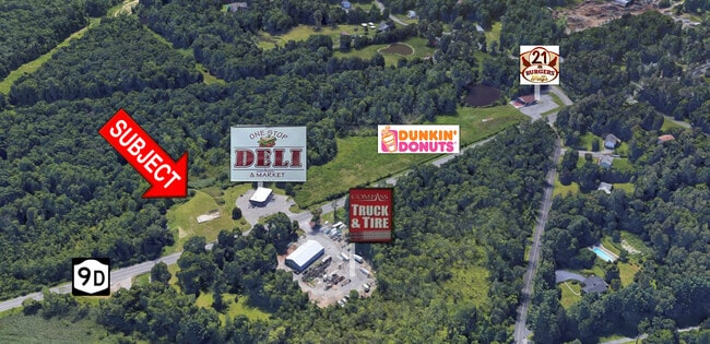
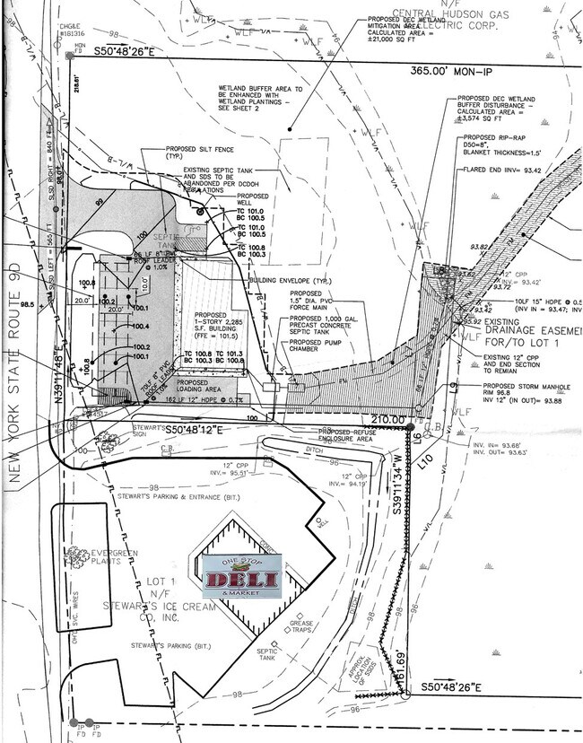
2054 Route 9D, Wappingers Falls, NY 12590

This Property Is For Sale
NEARBY LISTINGS FOR SALE OR LEASE
Property Detail
2054 Route 9D
Dutchess County-Putnam County, NY
Stewarts Shops
135689-6056-02-783920-0000
5.06 AC (S) 1704 0711 1628 0426
Commercialacreage
Dutchess
A
New York
36027C0462E
783
2025
5.06 AC
2024
Fishkill
190401
Westchester/So Connecticut
DEMOGRAPHICS near 2054 Route 9D
1 Mile
3 Mile
5 Mile
2024 Total Population
2,313
28,494
79,396
2029 Population
2,290
28,457
79,460
Pop Growth 2024-2029
(0.99%)
(0.13%)
+ 0.08%
Average Age
40
43
43
2024 Total Households
1,069
11,613
31,816
HH Growth 2024-2029
(1.03%)
(0.20%)
+ 0.03%
Median Household Inc
$88,453
$85,053
$91,775
Avg Household Size
2.10
2.30
2.40
2024 Avg HH Vehicles
2.00
2.00
2.00
Median Home Value
$326,666
$348,201
$362,334
Median Year Built
1968
1974
1971
Nearby Places
- Restaurants
- Banks
- Shops
- Fitness
- Groceries
PUBLIC TRANSPORTATION
COMMUTER RAIL
New Hamburg Station (Hudson Line - Metro-North Commuter Railroad Company (Metro-North))
DRIVE
WALK
Distance
New Hamburg Station (Hudson Line - Metro-North Commuter Railroad Company (Metro-North))
6 min
2.7 mi
Beacon Station (Hudson Line - Metro-North Commuter Railroad Company (Metro-North))
DRIVE
WALK
Distance
Beacon Station (Hudson Line - Metro-North Commuter Railroad Company (Metro-North))
10 min
5.0 mi
AIRPORT
New York Stewart International
DRIVE
WALK
Distance
New York Stewart International
24 min
13.5 mi
Freight Ports
Port of New Haven
DRIVE
WALK
Distance
Port of New Haven
101 min
73.8 mi
Nearby Properties
Address
Land Use
TOTAL SIZE
Lot Size
Zoning
Address
Land Use
TOTAL SIZE
Lot Size
Zoning
48,135 SF
40.98 AC
RMF5
Address
Land Use
TOTAL SIZE
Lot Size
Zoning
101,170 SF
28.71 AC
RMF5
Address
Land Use
TOTAL SIZE
Lot Size
Zoning
Address
Land Use
TOTAL SIZE
Lot Size
Zoning
114 AC
Address
Land Use
TOTAL SIZE
Lot Size
Zoning
11.76 AC
R4A
Address
Land Use
TOTAL SIZE
Lot Size
Zoning
293,984 SF
47.95 AC
RMF5
Address
Land Use
TOTAL SIZE
Lot Size
Zoning
94,340 SF
31.64 AC
RMF5
Address
Land Use
TOTAL SIZE
Lot Size
Zoning
143,274 SF
31.04 AC
R20/40
Address
Land Use
TOTAL SIZE
Lot Size
Zoning
47,187 SF
33 AC
R40
Address
Land Use
TOTAL SIZE
Lot Size
Zoning
21,996 SF
17.36 AC
RMF5
Address
Land Use
TOTAL SIZE
Lot Size
Zoning
123,536 SF
18.10 AC
GB
Address
Land Use
TOTAL SIZE
Lot Size
Zoning
32,920 SF
21.55 AC
CB-30
Address
Land Use
TOTAL SIZE
Lot Size
Zoning
211,760 SF
86.81 AC
SC
Address
Land Use
TOTAL SIZE
Lot Size
Zoning
40,030 SF
4.50 AC
HB
Address
Land Use
TOTAL SIZE
Lot Size
Zoning
466.77 AC
R40
Address
Land Use
TOTAL SIZE
Lot Size
Zoning
106,025 SF
7.20 AC
RM2
Address
Land Use
TOTAL SIZE
Lot Size
Zoning
38,699 SF
3.09 AC
GB
Address
Land Use
TOTAL SIZE
Lot Size
Zoning
192,321 SF
12.98 AC
SC
Address
Land Use
TOTAL SIZE
Lot Size
Zoning
Address
Land Use
TOTAL SIZE
Lot Size
Zoning
45,720 SF
13.68 AC
RMF5
Address
Land Use
TOTAL SIZE
Lot Size
Zoning
52,988 SF
3.80 AC
LHCSB
Address
Land Use
TOTAL SIZE
Lot Size
Zoning
47,968 SF
5.19 AC
GB
Address
Land Use
TOTAL SIZE
Lot Size
Zoning
103,422 SF
9.16 AC
CB-30
Address
Land Use
TOTAL SIZE
Lot Size
Zoning
50.90 AC
Address
Land Use
TOTAL SIZE
Lot Size
Zoning
109,900 SF
11.17 AC
PB
Address
Land Use
TOTAL SIZE
Lot Size
Zoning
35 AC
R40
Address
Land Use
TOTAL SIZE
Lot Size
Zoning
54,326 SF
12.82 AC
HB
Address
Land Use
TOTAL SIZE
Lot Size
Zoning
95,648 SF
8.59 AC
CB-32
Address
Land Use
TOTAL SIZE
Lot Size
Zoning
28,117 SF
5 AC
HB
Address
Land Use
TOTAL SIZE
Lot Size
Zoning
116,592 SF
3.40 AC
RM5
The World's #1 Commercial Real Estate Marketplace
Connect with us
© 2025 CoStar Group
The information above has been obtained from sources believed reliable. While we do not doubt its accuracy we have not verified it and make no guarantee, warranty or representation about it. It is your responsibility to independently confirm its accuracy and completeness. Any projections, opinions, assumptions, or estimates used are for example only and do not represent the current or future performance of the property. The value of this transaction to you depends on tax and other factors which should be evaluated by your tax, financial, and legal advisors. You and your advisors should conduct a careful, independent investigation of the property to determine to your satisfaction the suitability of the property for your needs.