Property Record
2055 Briggs Rd, Mount Laurel, NJ 08054
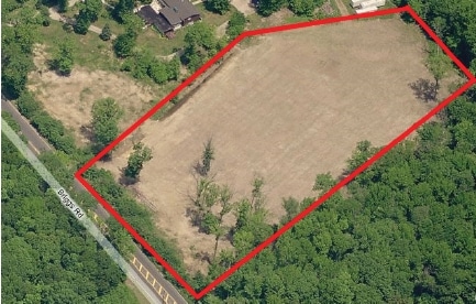

Property Detail
2055 Briggs Rd
Philadelphia-Camden-Wilmington, PA-NJ-DE-MD
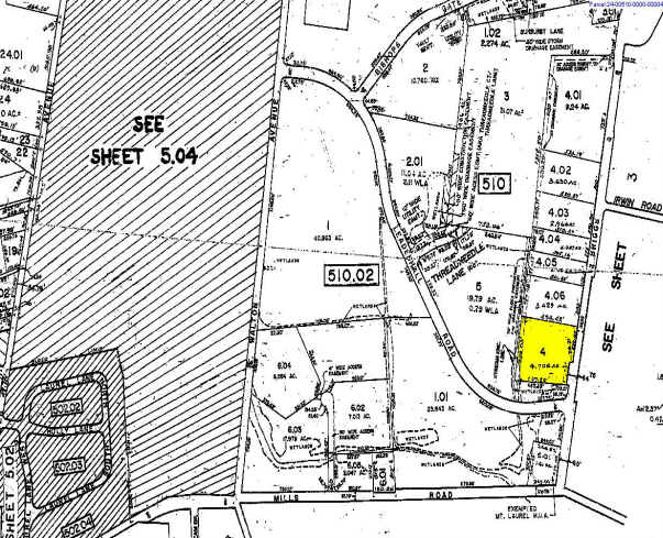
BURLINGTON
24-00510-0000-00004
New Jersey
Commercialnec
4
A Areas with a 1% annual chance of flooding and a 26% chance of flooding over the life of a 30-year mortgage.
4.71 AC
2024
South Burlington County
2025
Philadelphia
702910
NEARBY LISTINGS FOR SALE OR LEASE
DEMOGRAPHICS near 2055 Briggs Rd
1 mile
3 mile
5 mile
2025 Total Population
5,175
49,814
148,664
2030 Population
5,337
51,110
152,777
Pop Growth 2025-2030
+ 3.13%
+ 2.60%
+ 2.77%
Average Age
40
43
43
2025 Total Households
2,545
20,444
58,179
HH Growth 2025-2030
+ 3.34%
+ 2.60%
+ 2.81%
Median Household Inc
$100,705
$123,964
$116,260
Avg Household Size
2.00
2.40
2.50
2025 Avg HH Vehicles
1.00
2.00
2.00
Median Home Value
$277,231
$430,136
$406,442
Median Year Built
1987
1988
1981
Nearby Places
Map Layers
Map Styles
 Street
 Aerial
Transit
 Traffic
 Biking
Places
Listings with unknown addresses are not visible on the map
- Restaurants
- Banks
- Shops
- Fitness
- Groceries
PUBLIC TRANSPORTATION
AIRPORT
Philadelphia International
Drive
Walk
Distance
Philadelphia International
38 min
23.9 mi
Trenton Mercer
Drive
Walk
Distance
Trenton Mercer
46 min
30.5 mi
Freight Ports
Port of Philadelphia
Drive
Walk
Distance
Port of Philadelphia
21 min
14.0 mi
Nearby Properties
Address
Land Use
TOTAL SIZE
Lot Size
Zoning
Address
Land Use
TOTAL SIZE
Lot Size
Zoning
120.80 AC
Address
Land Use
TOTAL SIZE
Lot Size
Zoning
39.71 AC
Address
Land Use
TOTAL SIZE
Lot Size
Zoning
40.92 AC
Address
Land Use
TOTAL SIZE
Lot Size
Zoning
199,049 SF
15.90 AC
Address
Land Use
TOTAL SIZE
Lot Size
Zoning
74.17 AC
BRMF
Address
Land Use
TOTAL SIZE
Lot Size
Zoning
14.15 AC
Address
Land Use
TOTAL SIZE
Lot Size
Zoning
6.25 AC
Address
Land Use
TOTAL SIZE
Lot Size
Zoning
25.84 AC
Address
Land Use
TOTAL SIZE
Lot Size
Zoning
25.58 AC
Address
Land Use
TOTAL SIZE
Lot Size
Zoning
999,999,999 SF
88.63 AC
Address
Land Use
TOTAL SIZE
Lot Size
Zoning
79.67 AC
I
Address
Land Use
TOTAL SIZE
Lot Size
Zoning
8.31 AC
Address
Land Use
TOTAL SIZE
Lot Size
Zoning
Address
Land Use
TOTAL SIZE
Lot Size
Zoning
15.69 AC
Address
Land Use
TOTAL SIZE
Lot Size
Zoning
19.79 AC
Address
Land Use
TOTAL SIZE
Lot Size
Zoning
30.84 AC
Address
Land Use
TOTAL SIZE
Lot Size
Zoning
Address
Land Use
TOTAL SIZE
Lot Size
Zoning
14.46 AC
Address
Land Use
TOTAL SIZE
Lot Size
Zoning
24,186 SF
15.01 AC
Address
Land Use
TOTAL SIZE
Lot Size
Zoning
13.98 AC
Address
Land Use
TOTAL SIZE
Lot Size
Zoning
Address
Land Use
TOTAL SIZE
Lot Size
Zoning
13.15 AC
Address
Land Use
TOTAL SIZE
Lot Size
Zoning
24.49 AC
Address
Land Use
TOTAL SIZE
Lot Size
Zoning
15.46 AC
Address
Land Use
TOTAL SIZE
Lot Size
Zoning
23.76 AC
Address
Land Use
TOTAL SIZE
Lot Size
Zoning
Address
Land Use
TOTAL SIZE
Lot Size
Zoning
Address
Land Use
TOTAL SIZE
Lot Size
Zoning
Address
Land Use
TOTAL SIZE
Lot Size
Zoning
45.64 AC
Address
Land Use
TOTAL SIZE
Lot Size
Zoning
26.87 AC
The World's #1 Commercial Real Estate Marketplace
Connect with us
© 2026 CoStar Group
The information above has been obtained from sources believed reliable. While we do not doubt its accuracy we have not verified it and make no guarantee, warranty or representation about it. It is your responsibility to independently confirm its accuracy and completeness. Any projections, opinions, assumptions, or estimates used are for example only and do not represent the current or future performance of the property. The value of this transaction to you depends on tax and other factors which should be evaluated by your tax, financial, and legal advisors. You and your advisors should conduct a careful, independent investigation of the property to determine to your satisfaction the suitability of the property for your needs.