Property Record
2055 Grief Rd, Zanesville, OH 43701
NEARBY LISTINGS FOR SALE OR LEASE
Property Detail
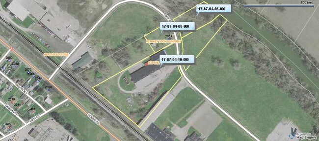
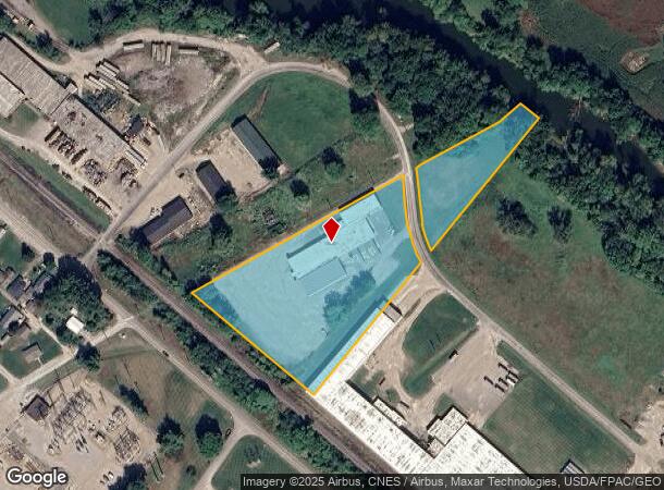
2055 Grief Rd
17-87-04-10-000
Licking View
Commercialnec
R 8 TP 1 QR TP 4 ON LICKING VIEW E PT 5.463A ABATEMENT TERMED 1/1/07
AE
Muskingum
39119C0285G
Ohio
2024
5.46 AC
2024
Ohio South Area
911400
Other Market Areas
22,561 SF
Zanesville, OH
DEMOGRAPHICS near 2055 Grief Rd
1 Mile
3 Mile
5 Mile
2024 Total Population
3,354
33,689
48,699
2029 Population
3,364
33,921
48,946
Pop Growth 2024-2029
+ 0.30%
+ 0.69%
+ 0.51%
Average Age
41
40
41
2024 Total Households
1,364
14,298
20,723
HH Growth 2024-2029
+ 0.29%
+ 0.62%
+ 0.44%
Median Household Inc
$50,833
$39,751
$45,830
Avg Household Size
2.30
2.30
2.30
2024 Avg HH Vehicles
2.00
2.00
2.00
Median Home Value
$137,707
$119,371
$130,963
Median Year Built
1952
1955
1963
Nearby Places
- Restaurants
- Banks
- Shops
- Fitness
- Groceries
Nearby Properties
Address
Land Use
TOTAL SIZE
Lot Size
Zoning
Address
Land Use
TOTAL SIZE
Lot Size
Zoning
219,630 SF
9.80 AC
O2
Address
Land Use
TOTAL SIZE
Lot Size
Zoning
41,718 SF
165.54 AC
Address
Land Use
TOTAL SIZE
Lot Size
Zoning
149,148 SF
61.69 AC
RS2
Address
Land Use
TOTAL SIZE
Lot Size
Zoning
114,644 SF
7.33 AC
RS2
Address
Land Use
TOTAL SIZE
Lot Size
Zoning
0.81 AC
Address
Land Use
TOTAL SIZE
Lot Size
Zoning
74,956 SF
10.45 AC
RS5
Address
Land Use
TOTAL SIZE
Lot Size
Zoning
8,694 SF
206.12 AC
AE
Address
Land Use
TOTAL SIZE
Lot Size
Zoning
6,344 SF
19.56 AC
Address
Land Use
TOTAL SIZE
Lot Size
Zoning
119,150 SF
9.13 AC
C2
Address
Land Use
TOTAL SIZE
Lot Size
Zoning
2,485 SF
28.07 AC
Address
Land Use
TOTAL SIZE
Lot Size
Zoning
14,968 SF
15.87 AC
C2
Address
Land Use
TOTAL SIZE
Lot Size
Zoning
83,031 SF
7.30 AC
RS4
Address
Land Use
TOTAL SIZE
Lot Size
Zoning
135,726 SF
16.84 AC
C4
Address
Land Use
TOTAL SIZE
Lot Size
Zoning
317,584 SF
49.15 AC
C2
Address
Land Use
TOTAL SIZE
Lot Size
Zoning
51,332 SF
5.50 AC
C4
Address
Land Use
TOTAL SIZE
Lot Size
Zoning
197,951 SF
22.47 AC
C2
Address
Land Use
TOTAL SIZE
Lot Size
Zoning
42,255 SF
6.51 AC
Address
Land Use
TOTAL SIZE
Lot Size
Zoning
26,455 SF
9.41 AC
Address
Land Use
TOTAL SIZE
Lot Size
Zoning
125,135 SF
13.85 AC
C2
Address
Land Use
TOTAL SIZE
Lot Size
Zoning
58,396 SF
9.83 AC
Address
Land Use
TOTAL SIZE
Lot Size
Zoning
32,100 SF
2.12 AC
C1
Address
Land Use
TOTAL SIZE
Lot Size
Zoning
64,732 SF
6.37 AC
RM1
Address
Land Use
TOTAL SIZE
Lot Size
Zoning
104,280 SF
9.77 AC
C4
Address
Land Use
TOTAL SIZE
Lot Size
Zoning
17,723 SF
0.94 AC
C4
Address
Land Use
TOTAL SIZE
Lot Size
Zoning
2,772 SF
4.72 AC
RM1
Address
Land Use
TOTAL SIZE
Lot Size
Zoning
6,320 SF
13.49 AC
PUD
Address
Land Use
TOTAL SIZE
Lot Size
Zoning
52,564 SF
0.80 AC
C3
Address
Land Use
TOTAL SIZE
Lot Size
Zoning
48,002 SF
7.13 AC
Address
Land Use
TOTAL SIZE
Lot Size
Zoning
10,469 SF
8.63 AC
RM1
Address
Land Use
TOTAL SIZE
Lot Size
Zoning
56,454 SF
1.50 AC
O2
The World's #1 Commercial Real Estate Marketplace
Connect with us
© 2025 CoStar Group
The information above has been obtained from sources believed reliable. While we do not doubt its accuracy we have not verified it and make no guarantee, warranty or representation about it. It is your responsibility to independently confirm its accuracy and completeness. Any projections, opinions, assumptions, or estimates used are for example only and do not represent the current or future performance of the property. The value of this transaction to you depends on tax and other factors which should be evaluated by your tax, financial, and legal advisors. You and your advisors should conduct a careful, independent investigation of the property to determine to your satisfaction the suitability of the property for your needs.