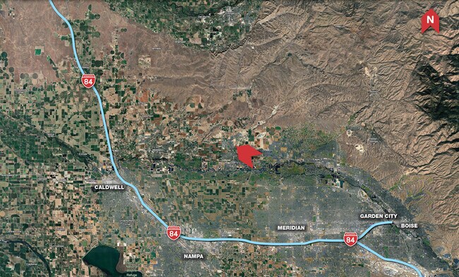
Property Record
2055 N Brandon Rd, Star, ID 83669
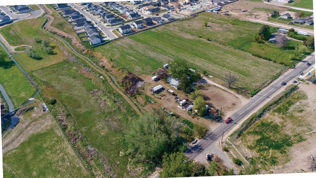
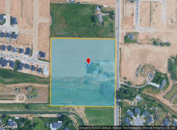
This Property Is For Sale
NEARBY LISTINGS FOR SALE OR LEASE
Property Detail
2055 N Brandon Rd
Boise City, ID
Ada
S0405325750
Idaho
Sfr
9.89 AC
X
Star
16001C0130J
Boise City/Nampa
1,493 SF
DEMOGRAPHICS near 2055 N Brandon Rd
1 Mile
3 Mile
5 Mile
2024 Total Population
6,049
19,240
40,216
2029 Population
7,180
23,351
49,131
Pop Growth 2024-2029
+ 18.70%
+ 21.37%
+ 22.17%
Average Age
42
43
42
2024 Total Households
2,052
6,757
13,862
HH Growth 2024-2029
+ 19.83%
+ 22.45%
+ 23.27%
Median Household Inc
$98,094
$87,631
$99,727
Avg Household Size
2.90
2.80
2.90
2024 Avg HH Vehicles
3.00
2.00
2.00
Median Home Value
$537,047
$632,330
$679,958
Median Year Built
2010
2010
2010
Nearby Places
Map Layers
Map Styles
 Street
 Aerial
- Restaurants
- Banks
- Shops
- Fitness
- Groceries
PUBLIC TRANSPORTATION
AIRPORT
Boise Air Trml/Gowen Field
DRIVE
WALK
Distance
Boise Air Trml/Gowen Field
49 min
27.1 mi
Freight Ports
Port of Portland
DRIVE
WALK
Distance
Port of Portland
464 min
415.8 mi
Nearby Properties
Address
Land Use
TOTAL SIZE
Lot Size
Zoning
Address
Land Use
TOTAL SIZE
Lot Size
Zoning
15.16 AC
R-14-DA
Address
Land Use
TOTAL SIZE
Lot Size
Zoning
178,710 SF
13.47 AC
R-13
Address
Land Use
TOTAL SIZE
Lot Size
Zoning
265.60 AC
R-2-DA
Address
Land Use
TOTAL SIZE
Lot Size
Zoning
227,392 SF
4.40 AC
L-O
Address
Land Use
TOTAL SIZE
Lot Size
Zoning
96,860 SF
12.62 AC
LI-DA
Address
Land Use
TOTAL SIZE
Lot Size
Zoning
2,496 SF
222.96 AC
R-2-DA
Address
Land Use
TOTAL SIZE
Lot Size
Zoning
174,428 SF
10 AC
MU
Address
Land Use
TOTAL SIZE
Lot Size
Zoning
246,075 SF
11.16 AC
C-2
Address
Land Use
TOTAL SIZE
Lot Size
Zoning
20,595 SF
2.32 AC
MU
Address
Land Use
TOTAL SIZE
Lot Size
Zoning
63,346 SF
6.87 AC
C-2
Address
Land Use
TOTAL SIZE
Lot Size
Zoning
132,187 SF
7.47 AC
MU
Address
Land Use
TOTAL SIZE
Lot Size
Zoning
89.84 AC
R-4-DA
Address
Land Use
TOTAL SIZE
Lot Size
Zoning
58,697 SF
4.86 AC
CBD-DA
Address
Land Use
TOTAL SIZE
Lot Size
Zoning
34,510 SF
3.20 AC
C-2
Address
Land Use
TOTAL SIZE
Lot Size
Zoning
6,683 SF
9.62 AC
C-1-DA
Address
Land Use
TOTAL SIZE
Lot Size
Zoning
52.23 AC
R-3
Address
Land Use
TOTAL SIZE
Lot Size
Zoning
266,148 SF
10.42 AC
MU-DA
Address
Land Use
TOTAL SIZE
Lot Size
Zoning
1,940 SF
31.43 AC
R-2-DA
Address
Land Use
TOTAL SIZE
Lot Size
Zoning
24.88 AC
Address
Land Use
TOTAL SIZE
Lot Size
Zoning
4,839 SF
0.77 AC
CBD
Address
Land Use
TOTAL SIZE
Lot Size
Zoning
38,414 SF
4.66 AC
R-8
Address
Land Use
TOTAL SIZE
Lot Size
Zoning
946 SF
19.93 AC
R-4
Address
Land Use
TOTAL SIZE
Lot Size
Zoning
4,041 SF
0.60 AC
C-2
Address
Land Use
TOTAL SIZE
Lot Size
Zoning
12.78 AC
R-4-DA
Address
Land Use
TOTAL SIZE
Lot Size
Zoning
11,873 SF
61.77 AC
MU-DA
Address
Land Use
TOTAL SIZE
Lot Size
Zoning
8,226 SF
1.74 AC
CBD-DA
Address
Land Use
TOTAL SIZE
Lot Size
Zoning
7,129 SF
1.11 AC
C-2
Address
Land Use
TOTAL SIZE
Lot Size
Zoning
9,294 SF
1.07 AC
MU-DA
Address
Land Use
TOTAL SIZE
Lot Size
Zoning
5,215 SF
0.93 AC
C-1-DA
Address
Land Use
TOTAL SIZE
Lot Size
Zoning
4,268 SF
0.93 AC
CBD
The World's #1 Commercial Real Estate Marketplace
Connect with us
© 2025 CoStar Group
The information above has been obtained from sources believed reliable. While we do not doubt its accuracy we have not verified it and make no guarantee, warranty or representation about it. It is your responsibility to independently confirm its accuracy and completeness. Any projections, opinions, assumptions, or estimates used are for example only and do not represent the current or future performance of the property. The value of this transaction to you depends on tax and other factors which should be evaluated by your tax, financial, and legal advisors. You and your advisors should conduct a careful, independent investigation of the property to determine to your satisfaction the suitability of the property for your needs.