Property Record
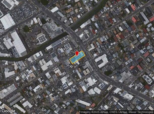
2055 N King St, Honolulu, HI 96819
NEARBY LISTINGS FOR SALE OR LEASE
Property Detail
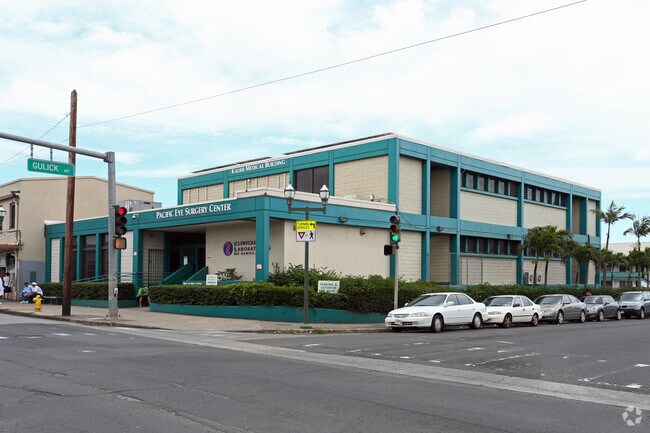
2055 N King St
Urban Honolulu, HI
Kalihi Medical Cent
1-1-2-011-092-0000
LOT 1-A 2,426 SF; LOT 2 2,518 SF; LOT 3 3,195 SF; LOT 4 3,195 SF; LOT 5 3,195 SF; LOT 6 3,195 SF SECTION D LCAPP 1051 MAP 2
Commercialnec
Honolulu
X
Hawaii
15003C0353G
1-a,2
2024
0.41 AC
2025
Kalihi
006000
Hawaii
19,175 SF
DEMOGRAPHICS near 2055 N King St
1 Mile
3 Mile
5 Mile
2024 Total Population
34,185
166,182
326,365
2029 Population
32,752
161,482
320,813
Pop Growth 2024-2029
(4.19%)
(2.83%)
(1.70%)
Average Age
39
42
43
2024 Total Households
8,074
57,882
125,091
HH Growth 2024-2029
(4.77%)
(3.00%)
(1.63%)
Median Household Inc
$72,755
$78,935
$75,310
Avg Household Size
3.70
2.60
2.40
2024 Avg HH Vehicles
2.00
1.00
1.00
Median Home Value
$709,040
$738,647
$738,136
Median Year Built
1966
1975
1974
Nearby Places
Map Layers
Map Styles
 Street
 Aerial
- Restaurants
- Banks
- Shops
- Fitness
- Groceries
PUBLIC TRANSPORTATION
AIRPORT
Daniel K Inouye International
DRIVE
WALK
Distance
Daniel K Inouye International
8 min
3.5 mi
SALE & LEASE HISTORY
LISTING DATE
SALE/LEASE

Sep 25, 2016
For Lease
Oct 27, 2017
For Lease
Nov 21, 2016
For Lease
Jun 27, 2024
For Sale
Jul 12, 2018
For Lease
Jan 13, 2020
For Lease
Aug 24, 2017
For Lease
Aug 24, 2017
For Lease
Nearby Properties
Address
Land Use
TOTAL SIZE
Lot Size
Zoning
Address
Land Use
TOTAL SIZE
Lot Size
Zoning
1,675.63 AC
C/61/60
Address
Land Use
TOTAL SIZE
Lot Size
Zoning
355.21 AC
F-1
Address
Land Use
TOTAL SIZE
Lot Size
Zoning
55.93 AC
WI
Address
Land Use
TOTAL SIZE
Lot Size
Zoning
1,153,381 SF
425.42 AC
R-5
Address
Land Use
TOTAL SIZE
Lot Size
Zoning
254,832 SF
2.92 AC
BMX-4
Address
Land Use
TOTAL SIZE
Lot Size
Zoning
1,725,655 SF
11 AC
I-2
Address
Land Use
TOTAL SIZE
Lot Size
Zoning
1,725,655 SF
11 AC
I-2
Address
Land Use
TOTAL SIZE
Lot Size
Zoning
12,430 SF
86.69 AC
P-1
Address
Land Use
TOTAL SIZE
Lot Size
Zoning
9,272 SF
141.38 AC
P-2
Address
Land Use
TOTAL SIZE
Lot Size
Zoning
163,285 SF
15.08 AC
R-7.5
Address
Land Use
TOTAL SIZE
Lot Size
Zoning
26,537 SF
2,470.86 AC
I-2
Address
Land Use
TOTAL SIZE
Lot Size
Zoning
1,447,909 SF
12.54 AC
IMX-1
Address
Land Use
TOTAL SIZE
Lot Size
Zoning
446,464 SF
9.90 AC
Kak
Address
Land Use
TOTAL SIZE
Lot Size
Zoning
919,972 SF
14.45 AC
I-2
Address
Land Use
TOTAL SIZE
Lot Size
Zoning
14.38 AC
Kak
Address
Land Use
TOTAL SIZE
Lot Size
Zoning
936,400 SF
6.88 AC
Kak
Address
Land Use
TOTAL SIZE
Lot Size
Zoning
386,846 SF
8.76 AC
A-1
Address
Land Use
TOTAL SIZE
Lot Size
Zoning
6.20 AC
I-2
Address
Land Use
TOTAL SIZE
Lot Size
Zoning
960 SF
71.97 AC
P-2
Address
Land Use
TOTAL SIZE
Lot Size
Zoning
158,215 SF
1.83 AC
BMX-4
Address
Land Use
TOTAL SIZE
Lot Size
Zoning
204,596 SF
0.12 AC
BMX-4
Address
Land Use
TOTAL SIZE
Lot Size
Zoning
253,254 SF
10.73 AC
Kak
Address
Land Use
TOTAL SIZE
Lot Size
Zoning
16.46 AC
I-2
Address
Land Use
TOTAL SIZE
Lot Size
Zoning
49,330 SF
50 AC
I-3
Address
Land Use
TOTAL SIZE
Lot Size
Zoning
10.84 AC
B-2
Address
Land Use
TOTAL SIZE
Lot Size
Zoning
13.77 AC
U/34/30
Address
Land Use
TOTAL SIZE
Lot Size
Zoning
40.76 AC
P-1
Address
Land Use
TOTAL SIZE
Lot Size
Zoning
4.70 AC
BMX-3
Address
Land Use
TOTAL SIZE
Lot Size
Zoning
415,924 SF
0.12 AC
BMX-4
The World's #1 Commercial Real Estate Marketplace
Connect with us
© 2025 CoStar Group
The information above has been obtained from sources believed reliable. While we do not doubt its accuracy we have not verified it and make no guarantee, warranty or representation about it. It is your responsibility to independently confirm its accuracy and completeness. Any projections, opinions, assumptions, or estimates used are for example only and do not represent the current or future performance of the property. The value of this transaction to you depends on tax and other factors which should be evaluated by your tax, financial, and legal advisors. You and your advisors should conduct a careful, independent investigation of the property to determine to your satisfaction the suitability of the property for your needs.