Property Record
20558 Glenn St, Elkhorn, NE 68022


Save to a Folder
{{folder.Name}}
{{folder.ListingIds.length}} Properties
{{folder.ListingIds.length}} Property
Create a New Folder
Property Detail
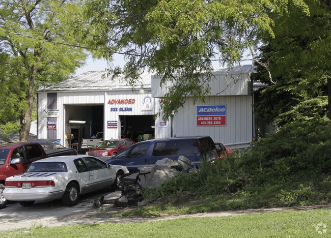
20558 Glenn St
4567-0000-21
SALINGS ADD TO ELKHORN LOT 9 BLOCK 10 1/2 VAC ALLEY & LT 8 & W 15 FT
Autorepair
Douglas
GC
Nebraska
B and X Area of moderate flood hazard, usually the area between the limits of the 100-year and 500-year floods.
9,8
2024
0.20 AC
2025
Northwest Omaha
007506
Omaha/Council Bluffs
3,560 SF
Omaha, NE-IA
NEARBY LISTINGS FOR SALE OR LEASE
DEMOGRAPHICS near 20558 Glenn St
1 mile
3 mile
5 mile
2025 Total Population
8,102
42,442
112,546
2030 Population
8,463
44,471
116,999
Pop Growth 2025-2030
+ 4.46%
+ 4.78%
+ 3.96%
Average Age
37
37
39
2025 Total Households
3,126
15,190
40,576
HH Growth 2025-2030
+ 4.73%
+ 4.92%
+ 3.99%
Median Household Inc
$106,865
$138,495
$133,188
Avg Household Size
2.50
2.70
2.70
2025 Avg HH Vehicles
2.00
2.00
2.00
Median Home Value
$352,745
$442,116
$399,297
Median Year Built
2007
2010
2004
Nearby Places
Map Layers
Map Styles
 Street
 Aerial
Layers
 Traffic
 Biking
Places
Listings with unknown addresses are not visible on the map
- Restaurants
- Banks
- Shops
- Fitness
- Groceries
PUBLIC TRANSPORTATION
AIRPORT
Eppley Airfield
Drive
Walk
Distance
Eppley Airfield
39 min
21.2 mi
Lincoln
Drive
Walk
Distance
Lincoln
60 min
48.6 mi
Nearby Properties
Address
Land Use
TOTAL SIZE
Lot Size
Zoning
Address
Land Use
TOTAL SIZE
Lot Size
Zoning
443,045 SF
22.82 AC
Address
Land Use
TOTAL SIZE
Lot Size
Zoning
486,568 SF
51.70 AC
ELKHORN
Address
Land Use
TOTAL SIZE
Lot Size
Zoning
420,483 SF
18.51 AC
R6
Address
Land Use
TOTAL SIZE
Lot Size
Zoning
362,573 SF
2.01 AC
Address
Land Use
TOTAL SIZE
Lot Size
Zoning
223,975 SF
11.91 AC
Address
Land Use
TOTAL SIZE
Lot Size
Zoning
241,312 SF
14.51 AC
Address
Land Use
TOTAL SIZE
Lot Size
Zoning
226,792 SF
8.97 AC
GO
Address
Land Use
TOTAL SIZE
Lot Size
Zoning
226,780 SF
8.23 AC
Address
Land Use
TOTAL SIZE
Lot Size
Zoning
232,559 SF
13.53 AC
R6
Address
Land Use
TOTAL SIZE
Lot Size
Zoning
215,645 SF
5.19 AC
Address
Land Use
TOTAL SIZE
Lot Size
Zoning
233,520 SF
15.39 AC
Address
Land Use
TOTAL SIZE
Lot Size
Zoning
355,421 SF
18.66 AC
Address
Land Use
TOTAL SIZE
Lot Size
Zoning
137,800 SF
6.69 AC
Address
Land Use
TOTAL SIZE
Lot Size
Zoning
143,817 SF
12.27 AC
Address
Land Use
TOTAL SIZE
Lot Size
Zoning
149,113 SF
7.64 AC
R6
Address
Land Use
TOTAL SIZE
Lot Size
Zoning
108,211 SF
6.53 AC
Address
Land Use
TOTAL SIZE
Lot Size
Zoning
107,052 SF
5.55 AC
Address
Land Use
TOTAL SIZE
Lot Size
Zoning
149,976 SF
7.15 AC
Address
Land Use
TOTAL SIZE
Lot Size
Zoning
169,105 SF
14.11 AC
Address
Land Use
TOTAL SIZE
Lot Size
Zoning
108,552 SF
6.87 AC
R5
Address
Land Use
TOTAL SIZE
Lot Size
Zoning
286,114 SF
10.39 AC
Address
Land Use
TOTAL SIZE
Lot Size
Zoning
241,480 SF
9.54 AC
Address
Land Use
TOTAL SIZE
Lot Size
Zoning
272,916 SF
27.09 AC
Address
Land Use
TOTAL SIZE
Lot Size
Zoning
182,501 SF
9.53 AC
Address
Land Use
TOTAL SIZE
Lot Size
Zoning
137,953 SF
6.01 AC
Address
Land Use
TOTAL SIZE
Lot Size
Zoning
171,808 SF
17.77 AC
Address
Land Use
TOTAL SIZE
Lot Size
Zoning
134,188 SF
6.05 AC
Address
Land Use
TOTAL SIZE
Lot Size
Zoning
164,725 SF
11.57 AC
Address
Land Use
TOTAL SIZE
Lot Size
Zoning
175,127 SF
14.12 AC
MU
Address
Land Use
TOTAL SIZE
Lot Size
Zoning
108,393 SF
4.59 AC
The World's #1 Commercial Real Estate Marketplace
Connect with us
© 2026 CoStar Group
The information above has been obtained from sources believed reliable. While we do not doubt its accuracy we have not verified it and make no guarantee, warranty or representation about it. It is your responsibility to independently confirm its accuracy and completeness. Any projections, opinions, assumptions, or estimates used are for example only and do not represent the current or future performance of the property. The value of this transaction to you depends on tax and other factors which should be evaluated by your tax, financial, and legal advisors. You and your advisors should conduct a careful, independent investigation of the property to determine to your satisfaction the suitability of the property for your needs.