Property Record
20575 W Indian School Rd, Buckeye, AZ 85396


Property Detail
20575 W Indian School Rd
502-77-004P
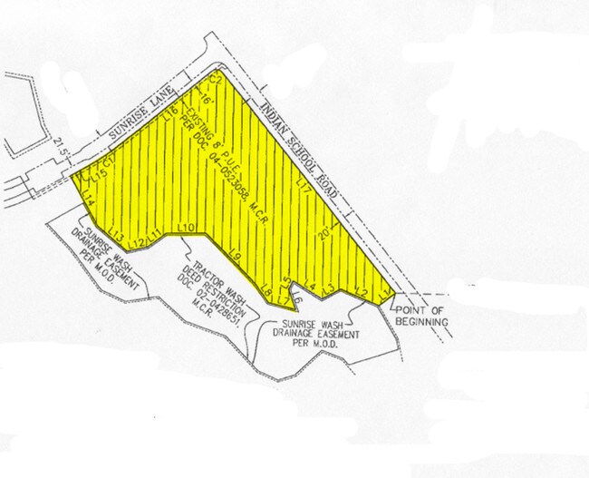
PAR LY WI/IN SEC 19 DAF COM E4 COR SD SEC TH S 1313.41F TH W 1686.29F POB TH S 51D 22M W 61F TH N 67D 58M W 123.08F TH S 61D 42M W 63.80F TH N 59D 30M W 100.43F TH S 27D 37M W 27.86F TH S 20D 48M E 63.72F TH N 76D 49M W 83.63F TH N 36D 28M W 65.07F T
Religious
MARICOPA
PAD
Arizona
AE The base floodplain where base flood elevations are provided. AE Zones are now used on new format FIRMs instead of A1-A30 Zones.
7.12 AC
0
West I-10
2025
Phoenix
050619
Phoenix-Mesa-Chandler, AZ
38,713 SF
NEARBY LISTINGS FOR SALE OR LEASE
-
-
View all Buckeye listings for sale on LoopNet.com
DEMOGRAPHICS near 20575 W Indian School Rd
1 mile
3 mile
5 mile
2025 Total Population
7,307
35,020
66,965
2030 Population
7,931
38,188
72,017
Pop Growth 2025-2030
+ 8.54%
+ 9.05%
+ 7.54%
Average Age
44
40
39
2025 Total Households
2,616
11,353
21,285
HH Growth 2025-2030
+ 9.40%
+ 9.41%
+ 7.78%
Median Household Inc
$165,799
$137,804
$119,893
Avg Household Size
2.80
3.00
3.10
2025 Avg HH Vehicles
2.00
3.00
2.00
Median Home Value
$666,985
$642,280
$514,087
Median Year Built
2010
2010
2010
Nearby Places
Map Layers
Map Styles
 Street
 Aerial
Layers
 Traffic
 Biking
Places
Listings with unknown addresses are not visible on the map
- Restaurants
- Banks
- Shops
- Fitness
- Groceries
PUBLIC TRANSPORTATION
AIRPORT
Phoenix Sky Harbor International
Drive
Walk
Distance
Phoenix Sky Harbor International
45 min
33.4 mi
Freight Ports
Port of San Diego
Drive
Walk
Distance
Port of San Diego
371 min
332.9 mi
SALE & LEASE HISTORY
LISTING DATE
SALE/LEASE

Sep 24, 2016
For Sale
Nearby Properties
Address
Land Use
TOTAL SIZE
Lot Size
Zoning
Address
Land Use
TOTAL SIZE
Lot Size
Zoning
18.73 AC
Address
Land Use
TOTAL SIZE
Lot Size
Zoning
13.35 AC
Address
Land Use
TOTAL SIZE
Lot Size
Zoning
9.44 AC
Address
Land Use
TOTAL SIZE
Lot Size
Zoning
11.14 AC
Address
Land Use
TOTAL SIZE
Lot Size
Zoning
166,213 SF
29.60 AC
PAD
Address
Land Use
TOTAL SIZE
Lot Size
Zoning
231,044 SF
48.70 AC
Address
Land Use
TOTAL SIZE
Lot Size
Zoning
19.06 AC
Address
Land Use
TOTAL SIZE
Lot Size
Zoning
185,251 SF
13.29 AC
PAD
Address
Land Use
TOTAL SIZE
Lot Size
Zoning
4.46 AC
Address
Land Use
TOTAL SIZE
Lot Size
Zoning
152,901 SF
22.52 AC
Address
Land Use
TOTAL SIZE
Lot Size
Zoning
Address
Land Use
TOTAL SIZE
Lot Size
Zoning
269,708 SF
15.51 AC
C2
Address
Land Use
TOTAL SIZE
Lot Size
Zoning
108,281 SF
11.95 AC
PC
Address
Land Use
TOTAL SIZE
Lot Size
Zoning
12,418 SF
54.25 AC
PC
Address
Land Use
TOTAL SIZE
Lot Size
Zoning
80,531 SF
7.51 AC
PAD
Address
Land Use
TOTAL SIZE
Lot Size
Zoning
40,300 SF
19.53 AC
CC
Address
Land Use
TOTAL SIZE
Lot Size
Zoning
44,463 SF
79.72 AC
RR
Address
Land Use
TOTAL SIZE
Lot Size
Zoning
Address
Land Use
TOTAL SIZE
Lot Size
Zoning
64,720 SF
2.24 AC
PC
Address
Land Use
TOTAL SIZE
Lot Size
Zoning
34,356 SF
14.43 AC
CC
Address
Land Use
TOTAL SIZE
Lot Size
Zoning
Address
Land Use
TOTAL SIZE
Lot Size
Zoning
13.47 AC
Address
Land Use
TOTAL SIZE
Lot Size
Zoning
Address
Land Use
TOTAL SIZE
Lot Size
Zoning
65,506 SF
5 AC
C-C
The World's #1 Commercial Real Estate Marketplace
Connect with us
© 2026 CoStar Group
The information above has been obtained from sources believed reliable. While we do not doubt its accuracy we have not verified it and make no guarantee, warranty or representation about it. It is your responsibility to independently confirm its accuracy and completeness. Any projections, opinions, assumptions, or estimates used are for example only and do not represent the current or future performance of the property. The value of this transaction to you depends on tax and other factors which should be evaluated by your tax, financial, and legal advisors. You and your advisors should conduct a careful, independent investigation of the property to determine to your satisfaction the suitability of the property for your needs.