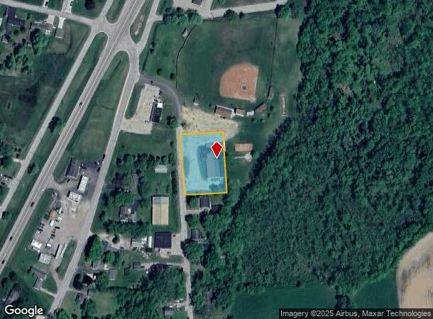
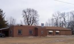
Property Record
206 N Lemke St, Cecil, WI 54111

NEARBY LISTINGS FOR SALE OR LEASE
-
-
View all Cecil listings for sale on LoopNet.com
Property Detail
206 N Lemke St
Shawano, WI
S16t27nr17e
111163300050
VIL OF CECIL COM 52 RD N OF SW COR OF SW 1/4 SW 1/4 TH E 165' N 236.5' W 165' S 236.5' TO POB EX PRT DES IN DOC #580955 SEC 16 T27N R17E
Commercialnec
Shawano
X
Wisconsin
55115C0354C
0.73 AC
2024
Wisconsin North Area
2024
Other Market Areas
100100
DEMOGRAPHICS near 206 N Lemke St
1 Mile
3 Mile
5 Mile
2024 Total Population
1,313
2,503
5,491
2029 Population
1,281
2,451
5,430
Pop Growth 2024-2029
(2.44%)
(2.08%)
(1.11%)
Average Age
45
48
47
2024 Total Households
566
1,132
2,417
HH Growth 2024-2029
(2.47%)
(2.12%)
(1.24%)
Median Household Inc
$68,918
$65,120
$64,939
Avg Household Size
2.30
2.20
2.20
2024 Avg HH Vehicles
2.00
2.00
2.00
Median Home Value
$236,363
$225,403
$194,187
Median Year Built
1979
1978
1978
Nearby Places
Map Layers
Map Styles
 Street
 Aerial
- Restaurants
- Banks
- Shops
- Fitness
- Groceries
PUBLIC TRANSPORTATION
AIRPORT
Green Bay/Austin Straubel International
DRIVE
WALK
Distance
Green Bay/Austin Straubel International
48 min
36.3 mi
SALE & LEASE HISTORY
LISTING DATE
SALE/LEASE

Mar 09, 2020
For Sale
Jul 10, 2018
For Sale
Dec 12, 2016
For Sale
Nearby Properties
Address
Land Use
TOTAL SIZE
Lot Size
Zoning
Address
Land Use
TOTAL SIZE
Lot Size
Zoning
Address
Land Use
TOTAL SIZE
Lot Size
Zoning
7.18 AC
Address
Land Use
TOTAL SIZE
Lot Size
Zoning
Address
Land Use
TOTAL SIZE
Lot Size
Zoning
9.32 AC
Address
Land Use
TOTAL SIZE
Lot Size
Zoning
40.52 AC
Address
Land Use
TOTAL SIZE
Lot Size
Zoning
3.67 AC
Address
Land Use
TOTAL SIZE
Lot Size
Zoning
3.59 AC
Address
Land Use
TOTAL SIZE
Lot Size
Zoning
0.41 AC
Address
Land Use
TOTAL SIZE
Lot Size
Zoning
0.75 AC
Address
Land Use
TOTAL SIZE
Lot Size
Zoning
Address
Land Use
TOTAL SIZE
Lot Size
Zoning
39.49 AC
Address
Land Use
TOTAL SIZE
Lot Size
Zoning
15.56 AC
Address
Land Use
TOTAL SIZE
Lot Size
Zoning
52.10 AC
Address
Land Use
TOTAL SIZE
Lot Size
Zoning
Address
Land Use
TOTAL SIZE
Lot Size
Zoning
1.18 AC
Address
Land Use
TOTAL SIZE
Lot Size
Zoning
46.96 AC
Address
Land Use
TOTAL SIZE
Lot Size
Zoning
2.08 AC
Address
Land Use
TOTAL SIZE
Lot Size
Zoning
4.37 AC
Address
Land Use
TOTAL SIZE
Lot Size
Zoning
0.52 AC
Address
Land Use
TOTAL SIZE
Lot Size
Zoning
Address
Land Use
TOTAL SIZE
Lot Size
Zoning
59.14 AC
Address
Land Use
TOTAL SIZE
Lot Size
Zoning
Address
Land Use
TOTAL SIZE
Lot Size
Zoning
Address
Land Use
TOTAL SIZE
Lot Size
Zoning
Address
Land Use
TOTAL SIZE
Lot Size
Zoning
Address
Land Use
TOTAL SIZE
Lot Size
Zoning
0.83 AC
Address
Land Use
TOTAL SIZE
Lot Size
Zoning
Address
Land Use
TOTAL SIZE
Lot Size
Zoning
25.13 AC
Address
Land Use
TOTAL SIZE
Lot Size
Zoning
0.45 AC
Address
Land Use
TOTAL SIZE
Lot Size
Zoning
0.48 AC
The World's #1 Commercial Real Estate Marketplace
Connect with us
© 2025 CoStar Group
The information above has been obtained from sources believed reliable. While we do not doubt its accuracy we have not verified it and make no guarantee, warranty or representation about it. It is your responsibility to independently confirm its accuracy and completeness. Any projections, opinions, assumptions, or estimates used are for example only and do not represent the current or future performance of the property. The value of this transaction to you depends on tax and other factors which should be evaluated by your tax, financial, and legal advisors. You and your advisors should conduct a careful, independent investigation of the property to determine to your satisfaction the suitability of the property for your needs.